Eureka Dunes

Log in to your account

AroundUs is a community-driven map of interesting places, built by curious explorers like you. It grows with every review, story, and photo you share.
Connect to save your favorite spots, contribute locations, and create personalized routes.
Continue with Google
Continue with Apple
Continue with X
Continue with Facebook
Continue with email
By continuing, you accept our Terms and Conditions and our Privacy Policy
Create an account
Add to collection
Map
Suggest a change
Share

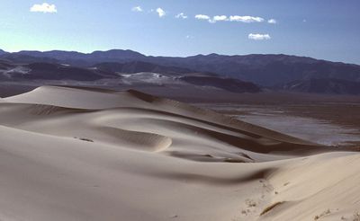
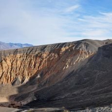
Eureka Dunes, Sand dune field in Inyo County, California, US.

Eureka Dunes is a sand dune field located in the northwestern section of Death Valley National Park in Inyo County. The dunes cover a substantial area and rise significantly from the valley floor.

The dune field received National Natural Landmark designation and became part of Death Valley National Park during the park's 1994 expansion. This protection status was established to preserve the fragile ecosystem.

The dunes support several plants and insects found nowhere else on Earth, adapted over time to this isolated desert location. These species thrive in an environment that few other organisms can tolerate.

The dunes are accessible via a graded dirt road that extends roughly 44 miles from Ubehebe Crater Road, requiring a vehicle capable of handling unpaved terrain. Primitive camping is available at designated spots near the base for those planning an overnight stay.

As dry sand cascades down the steepest slopes, it produces deep resonant sounds resembling pipe organ notes, a rare acoustic phenomenon that occurs only under specific conditions. Visitors who experience this sound find it one of the most memorable aspects of their visit.

Location: Inyo County

GPS coordinates: 37.09600,-117.67500

Latest update: December 8, 2025 19:48

Photos
Around this place
Methuselah
United States of America

Methuselah

54.9 km
Sailing stones
United States of America

Sailing stones

47.2 km
U.S. Route 395 in California
United States of America

U.S. Route 395 in California

56.1 km
Scotty's Castle
United States of America

Scotty's Castle

30.5 km
Ubehebe Crater
United States of America

Ubehebe Crater

22.2 km
Owens Valley Radio Observatory
United States of America

Owens Valley Radio Observatory

56 km
Saline Valley salt tram
United States of America

Saline Valley salt tram

56.6 km
Combined Array for Research in Millimeter-wave Astronomy
United States of America

Combined Array for Research in Millimeter-wave Astronomy

46.2 km
Saline Valley Hot Springs
United States of America

Saline Valley Hot Springs

33.5 km
Manzanar Children's Village
United States of America

Manzanar Children's Village

59.1 km
The Grandstand
United States of America

The Grandstand

45.9 km
Tinemaha Reservoir
United States of America

Tinemaha Reservoir

49 km
Mount Whitney Fish Hatchery
United States of America

Mount Whitney Fish Hatchery

58.6 km
Owens Valley Solar Array
United States of America

Owens Valley Solar Array

56.2 km
Inyo County Courthouse
United States of America

Inyo County Courthouse

56.8 km
Manzanar National Historic Site
United States of America

Manzanar National Historic Site

59.1 km
OVRO 40 meter Telescope
United States of America

OVRO 40 meter Telescope

56.1 km
Manzanar National Historic Site
United States of America

Manzanar National Historic Site

58.8 km
Racetrack mountain area
United States of America

Racetrack mountain area

47.2 km
Grapevine Peak
United States of America

Grapevine Peak

48.9 km
Lower Vine Ranch
United States of America

Lower Vine Ranch

27 km
Death Valley Scotty Historic District
United States of America

Death Valley Scotty Historic District

27 km
OVRO VLBA station
United States of America

OVRO VLBA station

55.5 km
Brewster VLBA station
United States of America

Brewster VLBA station

55.5 km
C-BASS North
United States of America

C-BASS North

56.1 km
Manzanar Visitor Center
United States of America

Manzanar Visitor Center

58.8 km
Mesquite Spring Campground
United States of America

Mesquite Spring Campground

31.1 km
Manzanar Sentry Posts
United States of America

Manzanar Sentry Posts

58.7 km
Show the full map
Reviews

Visited this place? Tap the stars to rate it and share your experience / photos with the community! Try now! You can cancel it anytime.

« Eureka Dunes - Sand dune field in Inyo County, California, US » is provided by Around Us (aroundus.com). Images and texts are derived from Wikimedia project under a Creative Commons license. You are allowed to copy, distribute, and modify copies of this page, under the conditions set by the license, as long as this note is clearly visible.

Discover hidden gems everywhere you go!

From secret cafés to breathtaking viewpoints, skip the crowded tourist spots and find places that match your style. Our app makes it easy with voice search, smart filtering, route optimization, and insider tips from travelers worldwide. Download now for the complete mobile experience.

Around Us App Screenshot

A unique approach to discovering new places

Le Figaro

All the places worth exploring

France Info

A tailor-made excursion in just a few clicks

20 Minutes