Enable Location

We need your location to show you interesting places around you

Discover nearby places

Find interesting locations and hidden gems around you

Precise directions

Get accurate directions and distances to places

Your location is never shared with other users. It's only used when you tap the location button.

The Grandstand

Log in to your account

Start exploring — it's free

Trusted by 62,838 travelers worldwide

Continue with Google
Continue with Apple
or

We will send you a code to connect

By continuing, you accept our Terms and Conditions and our Privacy Policy

Check your inbox

We've sent a pincode in your inbox. Please enter the code below.

The Grandstand

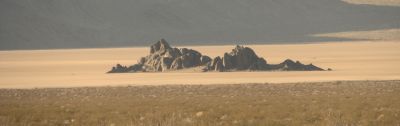
The Grandstand, Mountain summit in Death Valley National Park, California, US

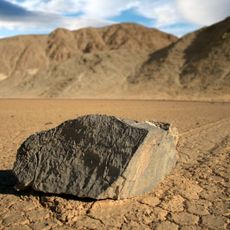
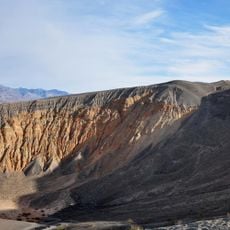
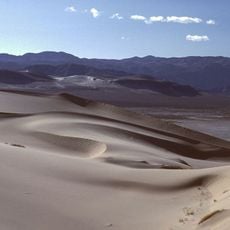
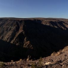
The Grandstand is a dark metamorphic rock formation rising from the Racetrack Playa floor in Death Valley. It stands at about 3,781 feet elevation and provides a vantage point overlooking the playa where rocks appear to move across the ground on their own.

The formation received its name in the 1920s when visitors thought it resembled stadium seating looking out over the natural racetrack formed by moving rocks. This naming came from early observers interpreting the shape and position of the rocks as they saw them.

Geologists and researchers frequently study this location to understand the mechanisms behind the moving rocks phenomenon on the surrounding playa.

Access requires high-clearance vehicles due to the roughly 27-mile unpaved road across rough terrain. Bring plenty of water, emergency supplies, and repair materials since help is far away and the area offers no services.

The dark rocks create a striking contrast against the pale playa surface, naturally drawing the eye to the puzzling rock trails below. Visitors often find that the shadows cast by the formation change throughout the day, creating different perspectives on the surrounding terrain.

The community of curious travelers

AroundUs brings together thousands of curated places, local tips, and hidden gems, enriched daily by 60,000 contributors worldwide.

Start exploring
Location
GPS coordinates
36.69272,-117.56646
Latest update
December 12, 2025 12:04
Around this place
Manzanar
United States of America

Manzanar

52.6 km
Sailing stones
United States of America

Sailing stones

1.3 km
Rainbow Canyon
United States of America

Rainbow Canyon

37 km
Scotty's Castle
United States of America

Scotty's Castle

42.8 km
Ubehebe Crater
United States of America

Ubehebe Crater

36.8 km
Darwin Falls
United States of America

Darwin Falls

41.6 km
Saline Valley salt tram
United States of America

Saline Valley salt tram

27.3 km
Eureka Dunes
United States of America

Eureka Dunes

45.9 km
Saline Valley Hot Springs
United States of America

Saline Valley Hot Springs

22.3 km
Darwin Falls Wilderness
United States of America

Darwin Falls Wilderness

39 km
Manzanar Children's Village
United States of America

Manzanar Children's Village

52.5 km
Inyo County Courthouse
United States of America

Inyo County Courthouse

57.7 km
Manzanar National Historic Site
United States of America

Manzanar National Historic Site

52.5 km
Manzanar National Historic Site
United States of America

Manzanar National Historic Site

52.1 km
Museum of Western Film History
United States of America

Museum of Western Film History

45.4 km
Racetrack mountain area
United States of America

Racetrack mountain area

1.3 km
Grapevine Peak
United States of America

Grapevine Peak

47.9 km
Lone Pine Film History Museum
United States of America

Lone Pine Film History Museum

45.4 km
Father Crowley Viewpoint
United States of America

Father Crowley Viewpoint

37.7 km
Lower Vine Ranch
United States of America

Lower Vine Ranch

39.6 km
Death Valley Scotty Historic District
United States of America

Death Valley Scotty Historic District

39.6 km
Manzanar Visitor Center
United States of America

Manzanar Visitor Center

52.1 km
Old Stovepipe Wells
United States of America

Old Stovepipe Wells

43.6 km
Mesquite Flat Sand Dunes
United States of America

Mesquite Flat Sand Dunes

42.2 km
Soul Consoling Tower
United States of America

Soul Consoling Tower

53.3 km
Stovepipe Wells Campground
United States of America

Stovepipe Wells Campground

38.6 km
Mesquite Spring Campground
United States of America

Mesquite Spring Campground

34.9 km
Manzanar Sentry Posts
United States of America

Manzanar Sentry Posts

51.8 km
Show the full map
« The Grandstand - Mountain summit in Death Valley National Park, California, US » is provided by Around Us (aroundus.com). Images and texts are derived from Wikimedia project under a Creative Commons license. You are allowed to copy, distribute, and modify copies of this page, under the conditions set by the license, as long as this note is clearly visible.

Discover hidden gems everywhere you go!

From secret cafés to breathtaking viewpoints, skip the crowded tourist spots and find places that match your style. Our app makes it easy with voice search, smart filtering, route optimization, and insider tips from travelers worldwide. Download now for the complete mobile experience.

Around Us App Screenshot

A unique approach to discovering new places

Le Figaro

All the places worth exploring

France Info

A tailor-made excursion in just a few clicks

20 Minutes

Around Us
Travel Guide & Maps
Download

Send to your phone

QR Code
1

Open the camera app on your mobile.

2

Point at the QR code with your camera. A notification will appear.

3

Tap the notification to open the link.