Chest opened
+${chestReward.xp} XP
Explorer
NOUVEAU ×${chestReward.collectible.quantity}
tapez pour fermer
Chest locked

Open chests in the app

Around Us is built for your phone — chests unlock when you walk, explore and capture nearby places.

Enable Location

We need your location to show you interesting places around you

Discover nearby places

Find interesting locations and hidden gems around you

Precise directions

Get accurate directions and distances to places

Your location is never shared with other users. It's only used when you tap the location button.

Summerlin

Log in to your account

Start exploring — it's free

Trusted by 72,890 travelers worldwide

Continue with Google
Continue with Apple
or

We will send you a code to connect

By continuing, you accept our Terms and Conditions and our Privacy Policy

Check your inbox

We've sent a pincode in your inbox. Please enter the code below.

Summerlin
Discussion Reviews 1 Photos
116k Popularity

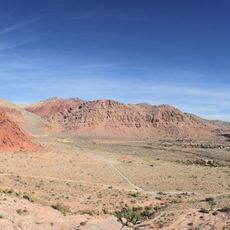
Summerlin, Planned community in Las Vegas Valley, United States

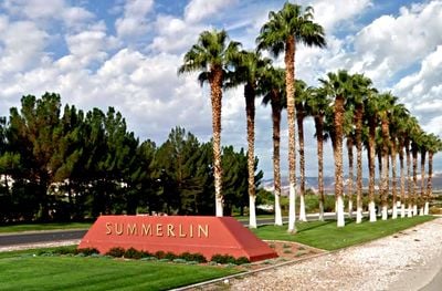
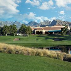
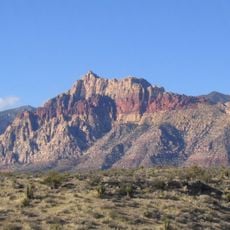
Summerlin is a planned residential community on the western edge of Las Vegas, Nevada, set between low hills and the Red Rock Canyon conservation area. It is made up of several distinct village centers, each with its own shops, schools, and open green spaces, all connected by a shared road network.

Development started in 1990 when the Howard Hughes Corporation began building on land that had belonged to the Hughes family for decades. The first residents moved in during the early 1990s, and the community has kept growing steadily ever since.

The name Summerlin comes from Jean Amelia Summerlin, the grandmother of Howard Hughes, who once owned this land. On weekends, the shaded paths and plazas in the village centers fill with residents out for a walk or gathering with neighbors.

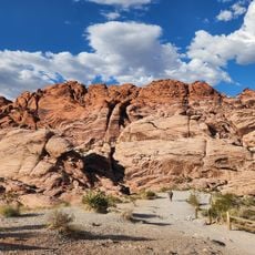
A car is the most practical way to get around, as the village centers are spread far apart. Bike lanes run through several neighborhoods and connect to the trails near Red Rock Canyon for those who prefer to ride.

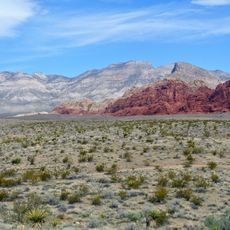
The land Summerlin sits on was once crossed by the Old Spanish Trail, a trade route used in the early 19th century to link New Mexico with California. That history is easy to overlook today, but the trail passed directly through what is now one of the most populated corners of the Las Vegas Valley.

The community of curious travelers

AroundUs brings together thousands of curated places, local tips, and hidden gems, enriched daily by 60,000 contributors worldwide.

Start exploring
Location
Inception
1990
GPS coordinates
36.18330,-115.33300
Latest update
March 3, 2026 08:21
Around this place
Red Rock Canyon National Conservation Area
United States of America

Red Rock Canyon National Conservation Area

10 km
Area15
United States of America

Area15

14.7 km
Red Rock Canyon National Conservation Area
United States of America

Red Rock Canyon National Conservation Area

9.5 km
Area15
United States of America

Area15

14.7 km
Texas Station
United States of America

Texas Station

12.9 km
Santa Fe Station
United States of America

Santa Fe Station

10.8 km
Erotic Heritage Museum
United States of America

Erotic Heritage Museum

15.4 km
Wet'n'Wild Las Vegas
United States of America

Wet'n'Wild Las Vegas

14 km
Southern Nevada Zoological-Botanical Park
United States of America

Southern Nevada Zoological-Botanical Park

12.9 km
Count's Kustoms
United States of America

Count's Kustoms

15.5 km
Springs Preserve
United States of America

Springs Preserve

12.8 km
Las Vegas Springs
United States of America

Las Vegas Springs

13 km
TPC at Summerlin
United States of America

TPC at Summerlin

3.5 km
Palms Place
United States of America

Palms Place

14.3 km
Arizona Charlie's Decatur
United States of America

Arizona Charlie's Decatur

11.5 km
Tivoli Village
United States of America

Tivoli Village

4.6 km
One Queensridge Place
United States of America

One Queensridge Place

3.9 km
Mini Gran Prix Family Fun Center
United States of America

Mini Gran Prix Family Fun Center

8.1 km
Nevada State Museum, Las Vegas
United States of America

Nevada State Museum, Las Vegas

12.9 km
Bridge Mountain
United States of America

Bridge Mountain

15.1 km
The Gardens at the Las Vegas Springs Preserve
United States of America

The Gardens at the Las Vegas Springs Preserve

13 km
Lorenzi Park
United States of America

Lorenzi Park

13.3 km
Eureka
United States of America

Eureka

12.3 km
Palms Casino Resort
United States of America

Palms Casino Resort

14.6 km
Magical Forest
United States of America

Magical Forest

9.7 km
Siena Golf Club
United States of America

Siena Golf Club

9 km
Faith Community Lutheran Church (Las Vegas)
United States of America

Faith Community Lutheran Church (Las Vegas)

6.4 km
Calico Basin
United States of America

Calico Basin

8.7 km
Show the full map
Reviews
Share your experience

No review yet

Discussions
Start a discussion...

No discussion yet

« Summerlin - Planned community in Las Vegas Valley, United States » is provided by Around Us (aroundus.com). Images and texts are derived from Wikimedia project under a Creative Commons license. You are allowed to copy, distribute, and modify copies of this page, under the conditions set by the license, as long as this note is clearly visible.

Discover hidden gems everywhere you go!

From secret cafés to breathtaking viewpoints, skip the crowded tourist spots and find places that match your style. Our app makes it easy with voice search, smart filtering, route optimization, and insider tips from travelers worldwide. Download now for the complete mobile experience.

Around Us App Screenshot

A unique approach to discovering new places

Le Figaro

All the places worth exploring

France Info

A tailor-made excursion in just a few clicks

20 Minutes

Around Us
Travel Guide & Maps
Download

Send to your phone

QR Code
1

Open the camera app on your mobile.

2

Point at the QR code with your camera. A notification will appear.

3

Tap the notification to open the link.