Chest opened
+${chestReward.xp} XP
Explorer
NOUVEAU ×${chestReward.collectible.quantity}
tapez pour fermer
Chest locked

Open chests in the app

Around Us is built for your phone — chests unlock when you walk, explore and capture nearby places.

Enable Location

We need your location to show you interesting places around you

Discover nearby places

Find interesting locations and hidden gems around you

Precise directions

Get accurate directions and distances to places

Your location is never shared with other users. It's only used when you tap the location button.

Log in to your account

Start exploring — it's free

Trusted by 72,982 travelers worldwide

Continue with Google
Continue with Apple
or

We will send you a code to connect

By continuing, you accept our Terms and Conditions and our Privacy Policy

Check your inbox

We've sent a pincode in your inbox. Please enter the code below.

Upper Burro Creek Wilderness
Discussion Reviews Photo
1.9k Popularity

Upper Burro Creek Wilderness, Natural wilderness area in Mohave County, Arizona

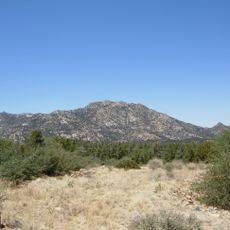
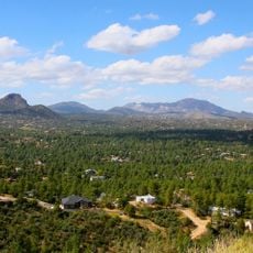
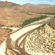
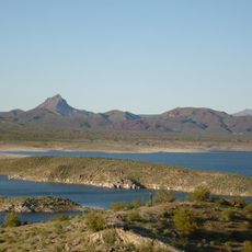
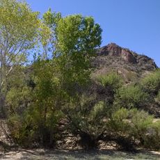
Upper Burro Creek Wilderness is a protected natural area that spans basalt plateaus and desert grasslands across Arizona. The creek cuts deep channels through the bedrock, creating a landscape of canyons, open plains, and scattered vegetation that changes with elevation and water availability.

The area received protected status in 1990 when the Bureau of Land Management designated it as a wilderness zone to safeguard Burro Creek and its surroundings. This decision reflected a commitment to keeping the landscape free from major development and industrial use.

The area serves as a refuge for mountain lions, mule deer, javelinas, and over 150 bird species that move through the landscape throughout the seasons. This abundance of wildlife gives the place a wild, living quality that visitors can sense while walking through the grasslands and along water sources.

Access requires four-wheel-drive vehicles, as clay-rich roads become difficult to navigate during rainy periods, making seasonal planning important for any visit. Travelers should prepare for rough terrain and rough conditions, and timing a trip during drier months helps avoid road problems.

The creek drops about 1,500 feet over a short distance, creating a series of clear blue pools connected by waterfalls carved into the bedrock. This dramatic change in elevation surprises many visitors, as such water features are uncommon in Arizona wilderness areas.

The community of curious travelers

AroundUs brings together thousands of curated places, local tips, and hidden gems, enriched daily by 60,000 contributors worldwide.

Start exploring
Location
GPS coordinates
34.70920,-113.28200
Latest update
December 14, 2025 11:43
Around this place
Alamo Lake State Park
United States of America

Alamo Lake State Park

60.7 km
Fort Whipple
United States of America

Fort Whipple

77.7 km
Granite Mountain
United States of America

Granite Mountain

65.1 km
Sharlot Hall Museum
United States of America

Sharlot Hall Museum

76.3 km
Arizona Pioneers' Home
United States of America

Arizona Pioneers' Home

76.4 km
United States of America

Granite Basin Lake

67.8 km
Bucky O'Neill Monument
United States of America

Bucky O'Neill Monument

76.8 km
Yavapai County Courthouse
United States of America

Yavapai County Courthouse

76.8 km
Hassayampa Inn
United States of America

Hassayampa Inn

76.9 km
Prescott Observatory
United States of America

Prescott Observatory

75.8 km
Seligman Commercial Historic District
United States of America

Seligman Commercial Historic District

78.1 km
Prescott Public Library
United States of America

Prescott Public Library

77 km
Smoki Museum
United States of America

Smoki Museum

77.6 km
Prescott Elks Theater and Performing Arts Center
United States of America

Prescott Elks Theater and Performing Arts Center

76.9 km
Arrastra Mountain Wilderness
United States of America

Arrastra Mountain Wilderness

25.5 km
Sacred Heart Catholic Church and Rectory
United States of America

Sacred Heart Catholic Church and Rectory

76.9 km
Iron Turbine Windmill
United States of America

Iron Turbine Windmill

76.3 km
United States Post Office and Courthouse–Prescott Main
United States of America

United States Post Office and Courthouse–Prescott Main

76.8 km
First Congregational Church and Parsonage
United States of America

First Congregational Church and Parsonage

77 km
Alamo Lake
United States of America

Alamo Lake

60.7 km
Prescott Public Library
United States of America

Prescott Public Library

76.9 km
Wegner Peak
United States of America

Wegner Peak

42.6 km
Brinkmeyer House
United States of America

Brinkmeyer House

76 km
Courthouse Plaza Historic District
United States of America

Courthouse Plaza Historic District

76.8 km
Sloan House
United States of America

Sloan House

77.3 km
Fredericks House
United States of America

Fredericks House

77.2 km
Clark House
United States of America

Clark House

77.2 km
Detwiler House
United States of America

Detwiler House

76.9 km
Show the full map
Reviews
Share your experience

No review yet

Discussions
Start a discussion...

No discussion yet

« Upper Burro Creek Wilderness - Natural wilderness area in Mohave County, Arizona » is provided by Around Us (aroundus.com). Images and texts are derived from Wikimedia project under a Creative Commons license. You are allowed to copy, distribute, and modify copies of this page, under the conditions set by the license, as long as this note is clearly visible.

Discover hidden gems everywhere you go!

From secret cafés to breathtaking viewpoints, skip the crowded tourist spots and find places that match your style. Our app makes it easy with voice search, smart filtering, route optimization, and insider tips from travelers worldwide. Download now for the complete mobile experience.

Around Us App Screenshot

A unique approach to discovering new places

Le Figaro

All the places worth exploring

France Info

A tailor-made excursion in just a few clicks

20 Minutes

Around Us
Travel Guide & Maps
Download

Send to your phone

QR Code
1

Open the camera app on your mobile.

2

Point at the QR code with your camera. A notification will appear.

3

Tap the notification to open the link.