Enable Location

We need your location to show you interesting places around you

Discover nearby places

Find interesting locations and hidden gems around you

Precise directions

Get accurate directions and distances to places

Your location is never shared with other users. It's only used when you tap the location button.

Log in to your account

Start exploring — it's free

Trusted by 61,972 travelers worldwide

Continue with Google
Continue with Apple
or

We will send you a code to connect

By continuing, you accept our Terms and Conditions and our Privacy Policy

Check your inbox

We've sent a pincode in your inbox. Please enter the code below.

Apache Creek Wilderness

Apache Creek Wilderness, Protected wilderness area in Yavapai County, Arizona

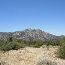
Apache Creek Wilderness is a protected area within the Prescott National Forest covering approximately 5,666 acres. The landscape features gently rolling hills with juniper and pinyon pine forest, punctuated by granite rock formations throughout.

Congress designated this area as a protected wilderness through the Arizona Wilderness Act of 1984. This legislation formed part of a broader effort to preserve wilderness lands across the Southwest region.

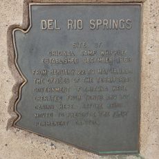
Native American communities used this land as a traditional passage and gathering site for resources before European settlement arrived. This heritage remains an important part of the region's identity.

Bring plenty of water, as the three natural springs in the area may not always be dependable. Check weather conditions before visiting, as the terrain is exposed in many places and conditions can change rapidly.

The terrain varies in elevation from 5,280 to 6,970 feet, creating distinct environmental zones with different plant and animal communities. This elevation change allows mountain lions and a surprising diversity of bird species to thrive in close proximity within the same wilderness.

The community of curious travelers

AroundUs brings together thousands of curated places, local tips, and hidden gems, enriched daily by 60,000 contributors worldwide.

Start exploring
Location
GPS coordinates
34.87830,-112.90400
Latest update
December 14, 2025 18:14
Around this place
Delgadillo's Snow Cap Drive-In
United States of America

Delgadillo's Snow Cap Drive-In

49.9 km
Fort Whipple
United States of America

Fort Whipple

54.8 km
Granite Mountain
United States of America

Granite Mountain

40 km
Sharlot Hall Museum
United States of America

Sharlot Hall Museum

54.3 km
Arizona Pioneers' Home
United States of America

Arizona Pioneers' Home

54.7 km
Granite Basin Lake
United States of America

Granite Basin Lake

43.5 km
Bucky O'Neill Monument
United States of America

Bucky O'Neill Monument

54.7 km
Yavapai County Courthouse
United States of America

Yavapai County Courthouse

54.7 km
Hassayampa Inn
United States of America

Hassayampa Inn

54.7 km
Seligman Commercial Historic District
United States of America

Seligman Commercial Historic District

50 km
Prescott Public Library
United States of America

Prescott Public Library

55 km
Smoki Museum
United States of America

Smoki Museum

55.2 km
Prescott Elks Theater and Performing Arts Center
United States of America

Prescott Elks Theater and Performing Arts Center

54.7 km
Sacred Heart Catholic Church and Rectory
United States of America

Sacred Heart Catholic Church and Rectory

54.6 km
Iron Turbine Windmill
United States of America

Iron Turbine Windmill

54.3 km
United States Post Office and Courthouse–Prescott Main
United States of America

United States Post Office and Courthouse–Prescott Main

54.8 km
First Congregational Church and Parsonage
United States of America

First Congregational Church and Parsonage

54.8 km
Prescott Public Library
United States of America

Prescott Public Library

54.8 km
Brinkmeyer House
United States of America

Brinkmeyer House

54.1 km
Courthouse Plaza Historic District
United States of America

Courthouse Plaza Historic District

54.7 km
Sloan House
United States of America

Sloan House

55.1 km
Fredericks House
United States of America

Fredericks House

55.1 km
Clark House
United States of America

Clark House

54.9 km
Detwiler House
United States of America

Detwiler House

54.5 km
Historic Angel's Barber Shop Museum
United States of America

Historic Angel's Barber Shop Museum

49.9 km
Big Hell Canyon Railroad Bridge
United States of America

Big Hell Canyon Railroad Bridge

49 km
Little Hell Canyon Bridge
United States of America

Little Hell Canyon Bridge

50.6 km
Presbyterian Church (Prescott, Arizona)
United States of America

Presbyterian Church (Prescott, Arizona)

54.7 km
Show the full map
« Apache Creek Wilderness - Protected wilderness area in Yavapai County, Arizona » is provided by Around Us (aroundus.com). Images and texts are derived from Wikimedia project under a Creative Commons license. You are allowed to copy, distribute, and modify copies of this page, under the conditions set by the license, as long as this note is clearly visible.

Discover hidden gems everywhere you go!

From secret cafés to breathtaking viewpoints, skip the crowded tourist spots and find places that match your style. Our app makes it easy with voice search, smart filtering, route optimization, and insider tips from travelers worldwide. Download now for the complete mobile experience.

Around Us App Screenshot

A unique approach to discovering new places

Le Figaro

All the places worth exploring

France Info

A tailor-made excursion in just a few clicks

20 Minutes

Around Us
Travel Guide & Maps
Download

Send to your phone

QR Code
1

Open the camera app on your mobile.

2

Point at the QR code with your camera. A notification will appear.

3

Tap the notification to open the link.