Enable Location

We need your location to show you interesting places around you

Discover nearby places

Find interesting locations and hidden gems around you

Precise directions

Get accurate directions and distances to places

Your location is never shared with other users. It's only used when you tap the location button.

Delgadillo's Snow Cap Drive-In

Log in to your account

Start exploring — it's free

Trusted by 61,953 travelers worldwide

Continue with Google
Continue with Apple
or

We will send you a code to connect

By continuing, you accept our Terms and Conditions and our Privacy Policy

Check your inbox

We've sent a pincode in your inbox. Please enter the code below.

Delgadillo's Snow Cap Drive-In

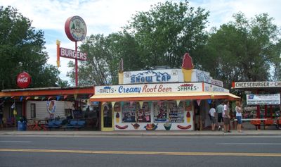
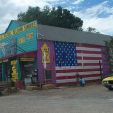
Delgadillo's Snow Cap Drive-In, Route 66 drive-in restaurant in Seligman, Arizona, United States.

Delgadillo's Snow Cap Drive-In is a Route 66 restaurant in Seligman featuring hand-painted signs, colorful decorations, and a modified 1936 Chevrolet with an artificial Christmas tree displayed in back. The building stands out with its bright designs and playful details throughout the space.

The owner established this roadside eatery in 1953 using salvaged lumber from a Santa Fe Railway yard to build the structure. The place grew from a practical idea to reuse materials and create a stop for travelers passing through.

The place takes its name from the owner's family and is known for its playful style, where visitors from around the world have left business cards covering the interior walls. This collection shows how the restaurant has drawn people from everywhere.

The restaurant sits at the east end of Seligman and is easily reached from Interstate 40 exits 121 and 123. It opens daily from 10 AM to 6 PM, giving travelers a clear window for a quick meal stop.

The front door has two knobs, with one being non-functional as part of the restaurant's playful concept. This small detail shows how the owner deliberately weaved humor into every corner of the space.

The community of curious travelers

AroundUs brings together thousands of curated places, local tips, and hidden gems, enriched daily by 60,000 contributors worldwide.

Start exploring
Location
GPS coordinates
35.32610,-112.87300
Latest update
December 8, 2025 13:40
Around this place
Grand Canyon Railway
United States of America

Grand Canyon Railway

70.9 km
Grand Canyon Caverns
United States of America

Grand Canyon Caverns

39.6 km
Bedrock City
United States of America

Bedrock City

75.8 km
Granite Mountain
United States of America

Granite Mountain

81 km
Granite Basin Lake
United States of America

Granite Basin Lake

84.2 km
Sycamore Canyon Wilderness
United States of America

Sycamore Canyon Wilderness

88.9 km
Red Butte
United States of America

Red Butte

89.7 km
Urban Route 66, Williams
United States of America

Urban Route 66, Williams

62.5 km
Seligman Commercial Historic District
United States of America

Seligman Commercial Historic District

111 m
Canyon Coaster Adventure Park
United States of America

Canyon Coaster Adventure Park

63.5 km
Barney Flat Historic Railroad Logging Landscape
United States of America

Barney Flat Historic Railroad Logging Landscape

68.6 km
Perkinsville Bridge
United States of America

Perkinsville Bridge

77.5 km
Schoolhouse at Truxton Canyon Training School
United States of America

Schoolhouse at Truxton Canyon Training School

71.8 km
Peach Springs Trading Post
United States of America

Peach Springs Trading Post

55.1 km
Camp Clover Ranger Station
United States of America

Camp Clover Ranger Station

60.3 km
First Methodist Episcopal Church and Parsonage
United States of America

First Methodist Episcopal Church and Parsonage

62.2 km
Williams Residential Historic District
United States of America

Williams Residential Historic District

63 km
Sycamore Falls
United States of America

Sycamore Falls

79.8 km
Route 66 Museum And Gift Shop
United States of America

Route 66 Museum And Gift Shop

62.2 km
Volunteer Lookout Cabin
United States of America

Volunteer Lookout Cabin

89.7 km
Historic Angel's Barber Shop Museum
United States of America

Historic Angel's Barber Shop Museum

58 m
Bill Williams Lookout Tower
United States of America

Bill Williams Lookout Tower

62.3 km
Thornton Lookout Tower
United States of America

Thornton Lookout Tower

60.2 km
Red Butte Lookout Tower
United States of America

Red Butte Lookout Tower

89.8 km
Volunteer Lookout Tower
United States of America

Volunteer Lookout Tower

89.6 km
Big Hell Canyon Railroad Bridge
United States of America

Big Hell Canyon Railroad Bridge

59.2 km
Little Hell Canyon Bridge
United States of America

Little Hell Canyon Bridge

50.5 km
Sycamore Canyon
United States of America

Sycamore Canyon

89.3 km
Show the full map
« Delgadillo's Snow Cap Drive-In - Route 66 drive-in restaurant in Seligman, Arizona, United States » is provided by Around Us (aroundus.com). Images and texts are derived from Wikimedia project under a Creative Commons license. You are allowed to copy, distribute, and modify copies of this page, under the conditions set by the license, as long as this note is clearly visible.

Discover hidden gems everywhere you go!

From secret cafés to breathtaking viewpoints, skip the crowded tourist spots and find places that match your style. Our app makes it easy with voice search, smart filtering, route optimization, and insider tips from travelers worldwide. Download now for the complete mobile experience.

Around Us App Screenshot

A unique approach to discovering new places

Le Figaro

All the places worth exploring

France Info

A tailor-made excursion in just a few clicks

20 Minutes

Around Us
Travel Guide & Maps
Download

Send to your phone

QR Code
1

Open the camera app on your mobile.

2

Point at the QR code with your camera. A notification will appear.

3

Tap the notification to open the link.