Enable Location

We need your location to show you interesting places around you

Discover nearby places

Find interesting locations and hidden gems around you

Precise directions

Get accurate directions and distances to places

Your location is never shared with other users. It's only used when you tap the location button.

Log in to your account

Start exploring — it's free

Trusted by 61,974 travelers worldwide

Continue with Google
Continue with Apple
or

We will send you a code to connect

By continuing, you accept our Terms and Conditions and our Privacy Policy

Check your inbox

We've sent a pincode in your inbox. Please enter the code below.

Juniper Mesa Wilderness

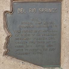
Juniper Mesa Wilderness, Protected wilderness area in Prescott National Forest, Arizona.

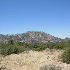
Juniper Mesa Wilderness is a protected landscape in Prescott National Forest featuring a central plateau surrounded by towering limestone cliffs. The terrain covers thousands of acres and includes multiple hiking routes that pass through different vegetation zones.

This area sits at the southern edge of the Colorado Plateau, shaped by ancient geological forces that lifted the land over time. The resulting rock formations visible today reflect millions of years of natural processes.

The natural landscape combines Tapeats sandstone and Martin and Redwall limestones, forming a geological monument within the surrounding granite terrain.

Access is provided through marked trails with varying difficulty levels for different hikers. The best time to visit is during milder months when temperatures are more comfortable for outdoor activities.

The north and south-facing slopes support completely different plant communities, creating stark contrasts in color and vegetation over short distances. This contrast makes the area particularly interesting for those observing how terrain shapes ecosystems.

The community of curious travelers

AroundUs brings together thousands of curated places, local tips, and hidden gems, enriched daily by 60,000 contributors worldwide.

Start exploring
Location
GPS coordinates
34.95220,-112.93500
Latest update
December 14, 2025 16:45
Around this place
Delgadillo's Snow Cap Drive-In
United States of America

Delgadillo's Snow Cap Drive-In

42 km
Fort Whipple
United States of America

Fort Whipple

62.5 km
Granite Mountain
United States of America

Granite Mountain

47.7 km
Sharlot Hall Museum
United States of America

Sharlot Hall Museum

62.2 km
Granite Basin Lake
United States of America

Granite Basin Lake

51.3 km
Bucky O'Neill Monument
United States of America

Bucky O'Neill Monument

62.5 km
Yavapai County Courthouse
United States of America

Yavapai County Courthouse

62.5 km
Seligman Commercial Historic District
United States of America

Seligman Commercial Historic District

42 km
Prescott Public Library
United States of America

Prescott Public Library

62.8 km
Prescott Elks Theater and Performing Arts Center
United States of America

Prescott Elks Theater and Performing Arts Center

62.5 km
Arrastra Mountain Wilderness
United States of America

Arrastra Mountain Wilderness

60.6 km
Sacred Heart Catholic Church and Rectory
United States of America

Sacred Heart Catholic Church and Rectory

62.4 km
Iron Turbine Windmill
United States of America

Iron Turbine Windmill

62.2 km
United States Post Office and Courthouse–Prescott Main
United States of America

United States Post Office and Courthouse–Prescott Main

62.6 km
First Congregational Church and Parsonage
United States of America

First Congregational Church and Parsonage

62.6 km
Prescott Public Library
United States of America

Prescott Public Library

62.6 km
Brinkmeyer House
United States of America

Brinkmeyer House

61.9 km
Courthouse Plaza Historic District
United States of America

Courthouse Plaza Historic District

62.5 km
Sloan House
United States of America

Sloan House

62.9 km
Fredericks House
United States of America

Fredericks House

62.9 km
Clark House
United States of America

Clark House

62.7 km
Detwiler House
United States of America

Detwiler House

62.3 km
Historic Angel's Barber Shop Museum
United States of America

Historic Angel's Barber Shop Museum

42 km
Big Hell Canyon Railroad Bridge
United States of America

Big Hell Canyon Railroad Bridge

50.6 km
Little Hell Canyon Bridge
United States of America

Little Hell Canyon Bridge

50.2 km
Presbyterian Church (Prescott, Arizona)
United States of America

Presbyterian Church (Prescott, Arizona)

62.5 km
Little Hell Canyon Railroad Bridge
United States of America

Little Hell Canyon Railroad Bridge

50.2 km
Granite Creek Bridge
United States of America

Granite Creek Bridge

62 km
Show the full map
« Juniper Mesa Wilderness - Protected wilderness area in Prescott National Forest, Arizona » is provided by Around Us (aroundus.com). Images and texts are derived from Wikimedia project under a Creative Commons license. You are allowed to copy, distribute, and modify copies of this page, under the conditions set by the license, as long as this note is clearly visible.

Discover hidden gems everywhere you go!

From secret cafés to breathtaking viewpoints, skip the crowded tourist spots and find places that match your style. Our app makes it easy with voice search, smart filtering, route optimization, and insider tips from travelers worldwide. Download now for the complete mobile experience.

Around Us App Screenshot

A unique approach to discovering new places

Le Figaro

All the places worth exploring

France Info

A tailor-made excursion in just a few clicks

20 Minutes

Around Us
Travel Guide & Maps
Download

Send to your phone

QR Code
1

Open the camera app on your mobile.

2

Point at the QR code with your camera. A notification will appear.

3

Tap the notification to open the link.