Enable Location

We need your location to show you interesting places around you

Discover nearby places

Find interesting locations and hidden gems around you

Precise directions

Get accurate directions and distances to places

Your location is never shared with other users. It's only used when you tap the location button.

South Kaibab Trail

Log in to your account

Start exploring — it's free

Trusted by 61,510 travelers worldwide

Continue with Google
Continue with Apple
or

We will send you a code to connect

By continuing, you accept our Terms and Conditions and our Privacy Policy

Check your inbox

We've sent a pincode in your inbox. Please enter the code below.

South Kaibab Trail, Hiking trail in Grand Canyon, Arizona.

Description

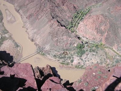
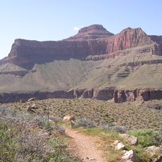
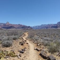
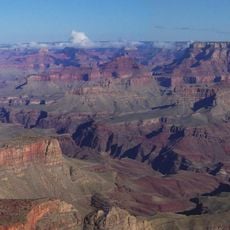
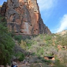
The South Kaibab Trail is a hiking path in Grand Canyon, Arizona, running 7 miles (11 kilometers) from the rim to the Colorado River and following a ridgeline. The route offers open views in every direction and crosses multiple geological layers showing millions of years of Earth history.

History

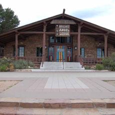
The National Park Service built the path in 1924 to create an alternative to the privately operated Bright Angel Trail. Completion allowed the administration to control river access independently and better manage visitor movement.

Culture

The name Kaibab comes from the Paiute language and means mountain lying down, describing the steep cliffs and inverted layers. Hikers here walk through terrain used for centuries by traders and hunters, now drawing visitors from around the world.

Practical

Hikers must carry enough water as there are no sources along the entire route and shade is rare. Early morning hours work best for descent, especially during hot months when the sun hits the rock directly.

Did you know?

At Cedar Ridge, roughly 1.5 miles from the starting point, fossil tracks of reptiles appear in the sandstone. These prints show how animals walked through this area millions of years ago when it was an entirely different landscape.

Location
Part of
Arizona Trail
GPS coordinates
36.05290,-112.08300
Latest update
December 20, 2025 01:56

AroundUs brings together thousands of curated places, local tips, and hidden gems, enriched daily by 60,000 contributors worldwide. Discover all places nearby (Coconino County).

Around this place
Grand Canyon National Park
United States of America

Grand Canyon National Park

3.5 km
El Tovar Hotel
United States of America

El Tovar Hotel

4.9 km
Bright Angel Lodge
United States of America

Bright Angel Lodge

5.2 km
Hopi House
United States of America

Hopi House

4.9 km
Kaibab Trail Suspension Bridge
United States of America

Kaibab Trail Suspension Bridge

5.4 km
Tonto Trail
United States of America

Tonto Trail

3.4 km
Kolb Studio
United States of America

Kolb Studio

5.4 km
Grand Canyon Depot
United States of America

Grand Canyon Depot

4.8 km
Grand Canyon Village Historic District
United States of America

Grand Canyon Village Historic District

5 km
Lookout Studio
United States of America

Lookout Studio

5.3 km
Buckey O'Neill Cabin
United States of America

Buckey O'Neill Cabin

5.3 km
Plateau Point Trail
United States of America

Plateau Point Trail

5.2 km
Mary Jane Colter buildings
United States of America

Mary Jane Colter buildings

5.3 km
Grand Canyon South Rim Ranger's Dormitory
United States of America

Grand Canyon South Rim Ranger's Dormitory

4.8 km
Grand Canyon Power House
United States of America

Grand Canyon Power House

5.2 km
Newton Butte
United States of America

Newton Butte

2.8 km
Grand Canyon National Park Superintendent's Residence
United States of America

Grand Canyon National Park Superintendent's Residence

4.7 km
Grand Canyon Park Operations Building
United States of America

Grand Canyon Park Operations Building

4.9 km
El Tovar Stables
United States of America

El Tovar Stables

5.2 km
Grand Canyon Visitor Center
United States of America

Grand Canyon Visitor Center

2.5 km
Yavapai Geology Museum
United States of America

Yavapai Geology Museum

3.4 km
Silver Bridge
United States of America

Silver Bridge

5.1 km
Yavapai Museum of Geology
United States of America

Yavapai Museum of Geology

3.4 km
Verkamp's Visitor Center
United States of America

Verkamp's Visitor Center

4.8 km
Horace M. Albright Training Center
United States of America

Horace M. Albright Training Center

4.6 km
Grand Canyon Visitor Center
United States of America

Grand Canyon Visitor Center

2.5 km
Trailer Village
United States of America

Trailer Village

2.9 km
Mile-and-a-Half Resthouse
United States of America

Mile-and-a-Half Resthouse

5.1 km
Show the full map
« South Kaibab Trail - Hiking trail in Grand Canyon, Arizona » is provided by Around Us (aroundus.com). Images and texts are derived from Wikimedia project under a Creative Commons license. You are allowed to copy, distribute, and modify copies of this page, under the conditions set by the license, as long as this note is clearly visible.

Discover hidden gems everywhere you go!

From secret cafés to breathtaking viewpoints, skip the crowded tourist spots and find places that match your style. Our app makes it easy with voice search, smart filtering, route optimization, and insider tips from travelers worldwide. Download now for the complete mobile experience.

Around Us App Screenshot

A unique approach to discovering new places

Le Figaro

All the places worth exploring

France Info

A tailor-made excursion in just a few clicks

20 Minutes

Around Us
Travel Guide & Maps
Download

Send to your phone

QR Code
1

Open the camera app on your mobile.

2

Point at the QR code with your camera. A notification will appear.

3

Tap the notification to open the link.