Enable Location

We need your location to show you interesting places around you

Discover nearby places

Find interesting locations and hidden gems around you

Precise directions

Get accurate directions and distances to places

Your location is never shared with other users. It's only used when you tap the location button.

Little Sahara Recreation Area

Log in to your account

Start exploring — it's free

Trusted by 64,832 travelers worldwide

Continue with Google
Continue with Apple
or

We will send you a code to connect

By continuing, you accept our Terms and Conditions and our Privacy Policy

Check your inbox

We've sent a pincode in your inbox. Please enter the code below.

Little Sahara Recreation Area
Discussion Reviews 1 Photos
5.4k Popularity

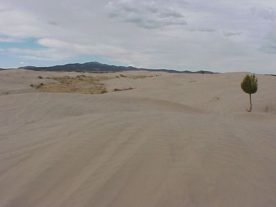
Little Sahara Recreation Area, Sand dunes recreation area in Juab County, United States

Little Sahara Recreation Area is a desert recreation area in Juab County, Utah, made up of open sand dunes, flat sagebrush plains, and juniper-covered hills. The grounds are divided into separate zones, each offering a different type of terrain, from loose rolling dunes to more sheltered wooded spots.

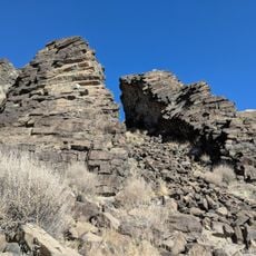
The dunes formed after ancient Lake Bonneville receded and left behind fine sediments across the basin. Over thousands of years, prevailing winds shaped those deposits into the dune system that visitors see today.

Little Sahara is known as a gathering place for off-highway vehicle riders who come to drive across the open dunes. On long weekends, families and groups camp together and spend the day on the sand, turning the area into a social destination.

The area is far from major towns, so it is worth arriving with enough water, food, and fuel before you get there. Weekdays tend to be much quieter than holiday periods, which makes them a better time to explore the dunes at your own pace.

Sand Mountain, the tallest dune in the area, produces a deep humming sound when sand slides down its face, a phenomenon sometimes called a singing dune. This sound is caused by dry sand grains moving against each other in just the right conditions and is rarely heard at most dune fields.

The community of curious travelers

AroundUs brings together thousands of curated places, local tips, and hidden gems, enriched daily by 60,000 contributors worldwide.

Start exploring
Location
Elevation above the sea
1,556 m
GPS coordinates
39.72610,-112.30700
Latest update
March 3, 2026 10:08
Around this place
Mount Nebo
United States of America

Mount Nebo

48 km
Payson Utah Temple
United States of America

Payson Utah Temple

57.7 km
Yuba State Park
United States of America

Yuba State Park

45.5 km
Baker Hot Springs
United States of America

Baker Hot Springs

38.3 km
Fumarole Butte
United States of America

Fumarole Butte

43.4 km
West Mountain
United States of America

West Mountain

57.8 km
George Carter Whitmore Mansion
United States of America

George Carter Whitmore Mansion

40.4 km
Harker Canyon (Tooele County, Utah)
United States of America

Harker Canyon (Tooele County, Utah)

32.7 km
Edwin Robert Booth House
United States of America

Edwin Robert Booth House

40.3 km
Santaquin Junior High School
United States of America

Santaquin Junior High School

53.3 km
David Morgan House
United States of America

David Morgan House

42.7 km
Eureka LDS Church Meetinghouse
United States of America

Eureka LDS Church Meetinghouse

30.2 km
Oscar M. Booth House
United States of America

Oscar M. Booth House

40.2 km
Thuesen-Petersen House
United States of America

Thuesen-Petersen House

56.7 km
Scipio Town Hall
United States of America

Scipio Town Hall

56.3 km
John C. Sharp House
United States of America

John C. Sharp House

41.7 km
Knight Grain Elevator
United States of America

Knight Grain Elevator

25.9 km
Eureka Lilly Headframe
United States of America

Eureka Lilly Headframe

32.4 km
Peter Quarnberg House
United States of America

Peter Quarnberg House

56.5 km
Fountain Green Hydroelectric Plant Historic District
United States of America

Fountain Green Hydroelectric Plant Historic District

57.1 km
Topaz Museum
United States of America

Topaz Museum

47.6 km
Great Basin Museum
United States of America

Great Basin Museum

47.6 km
Mount Nebo Wilderness
United States of America

Mount Nebo Wilderness

47.5 km
Big Canyon
United States of America

Big Canyon

36.1 km
Devils Kitchen (Juab County, Utah)
United States of America

Devils Kitchen (Juab County, Utah)

53.7 km
Homansville Canyon
United States of America

Homansville Canyon

34.7 km
Eureka Historic District
United States of America

Eureka Historic District

30.2 km
Paul Bunyan's Woodpile
United States of America

Paul Bunyan's Woodpile

17 km
Show the full map
Reviews
Share your experience

No review yet

Discussions
Start a discussion...

No discussion yet

« Little Sahara Recreation Area - Sand dunes recreation area in Juab County, United States » is provided by Around Us (aroundus.com). Images and texts are derived from Wikimedia project under a Creative Commons license. You are allowed to copy, distribute, and modify copies of this page, under the conditions set by the license, as long as this note is clearly visible.

Discover hidden gems everywhere you go!

From secret cafés to breathtaking viewpoints, skip the crowded tourist spots and find places that match your style. Our app makes it easy with voice search, smart filtering, route optimization, and insider tips from travelers worldwide. Download now for the complete mobile experience.

Around Us App Screenshot

A unique approach to discovering new places

Le Figaro

All the places worth exploring

France Info

A tailor-made excursion in just a few clicks

20 Minutes

Around Us
Travel Guide & Maps
Download

Send to your phone

QR Code
1

Open the camera app on your mobile.

2

Point at the QR code with your camera. A notification will appear.

3

Tap the notification to open the link.