Enable Location

We need your location to show you interesting places around you

Discover nearby places

Find interesting locations and hidden gems around you

Precise directions

Get accurate directions and distances to places

Your location is never shared with other users. It's only used when you tap the location button.

The Cinders

Log in to your account

Start exploring — it's free

Trusted by 61,763 travelers worldwide

Continue with Google
Continue with Apple
or

We will send you a code to connect

By continuing, you accept our Terms and Conditions and our Privacy Policy

Check your inbox

We've sent a pincode in your inbox. Please enter the code below.

The Cinders

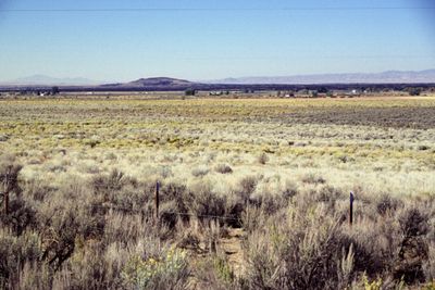
The Cinders, Lava field in Millard County, Utah, US

Description

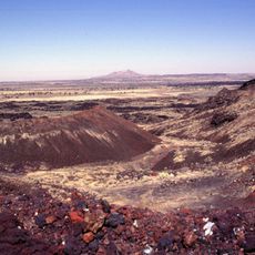
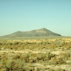
The Cinders is a lava field in west-central Utah characterized by volcanic hills and dark basalt formations spread across the landscape. The ground here shows jagged black rock surfaces and cinder cones that mark where volcanic activity once shaped the terrain.

History

Geologists Grove Karl Gilbert and Israel Russell first mapped this location in 1890, providing the initial scientific documentation of the formation. Their work established the foundation for understanding the region's volcanic history.

Culture

The site provides opportunities for geological research and education about volcanic processes through examination of rock samples and surface formations.

Practical

The surface here is rough and rocky, requiring sturdy footwear and careful movement across the jagged ground. Visitors should bring plenty of water, sun protection, and plan visits during cooler parts of the day since the dark rocks absorb significant heat.

Did you know?

This location contains some of the youngest basalt eruptions in Utah, with lava flowing from Ice Springs craters less than 700 years ago in geological terms. This recent volcanic activity makes it different from older lava fields found elsewhere in the state.

Location
GPS coordinates
38.96330,-112.50430
Latest update
December 14, 2025 18:12

AroundUs brings together thousands of curated places, local tips, and hidden gems, enriched daily by 60,000 contributors worldwide. Discover all places nearby (Millard County).

Around this place
Mystic Hot Springs
United States of America

Mystic Hot Springs

50.2 km
Telescope Array Project
United States of America

Telescope Array Project

51 km
Fremont Indian State Park and Museum
United States of America

Fremont Indian State Park and Museum

45.4 km
Utah Territorial Statehouse
United States of America

Utah Territorial Statehouse

15.4 km
Black Rock Desert volcanic field
United States of America

Black Rock Desert volcanic field

528 m
Pahvant Butte
United States of America

Pahvant Butte

19.2 km
Fort Deseret
United States of America

Fort Deseret

36 km
Marysvale Canyon
United States of America

Marysvale Canyon

53.8 km
Richfield Carnegie Library
United States of America

Richfield Carnegie Library

42.5 km
Monroe Presbyterian Church
United States of America

Monroe Presbyterian Church

49.5 km
Edward and Elizabeth Partridge House
United States of America

Edward and Elizabeth Partridge House

15.2 km
Thuesen-Petersen House
United States of America

Thuesen-Petersen House

46.5 km
Scipio Town Hall
United States of America

Scipio Town Hall

46.8 km
Jens Larson Jenson Lime Kiln
United States of America

Jens Larson Jenson Lime Kiln

40.9 km
Martin Johnson House
United States of America

Martin Johnson House

50.1 km
Elsinore White Rock Schoolhouse
United States of America

Elsinore White Rock Schoolhouse

43.7 km
Soren Simonsen House
United States of America

Soren Simonsen House

49.4 km
Peter Quarnberg House
United States of America

Peter Quarnberg House

46.5 km
Kanosh Tithing Office
United States of America

Kanosh Tithing Office

18.9 km
Redmond Town Hall
United States of America

Redmond Town Hall

55.6 km
Monroe City Hall
United States of America

Monroe City Hall

49.5 km
Fillmore American Legion Hall
United States of America

Fillmore American Legion Hall

15.6 km
Peterson–Burr House
United States of America

Peterson–Burr House

55.6 km
Peter and Jessie Huntsman House
United States of America

Peter and Jessie Huntsman House

15.3 km
Territorial Statehouse State Park Museum
United States of America

Territorial Statehouse State Park Museum

15.5 km
Topaz Museum
United States of America

Topaz Museum

43.7 km
Millard County Courthouse
United States of America

Millard County Courthouse

15.6 km
Great Basin Museum
United States of America

Great Basin Museum

43.7 km
Show the full map
« The Cinders - Lava field in Millard County, Utah, US » is provided by Around Us (aroundus.com). Images and texts are derived from Wikimedia project under a Creative Commons license. You are allowed to copy, distribute, and modify copies of this page, under the conditions set by the license, as long as this note is clearly visible.

Discover hidden gems everywhere you go!

From secret cafés to breathtaking viewpoints, skip the crowded tourist spots and find places that match your style. Our app makes it easy with voice search, smart filtering, route optimization, and insider tips from travelers worldwide. Download now for the complete mobile experience.

Around Us App Screenshot

A unique approach to discovering new places

Le Figaro

All the places worth exploring

France Info

A tailor-made excursion in just a few clicks

20 Minutes

Around Us
Travel Guide & Maps
Download

Send to your phone

QR Code
1

Open the camera app on your mobile.

2

Point at the QR code with your camera. A notification will appear.

3

Tap the notification to open the link.