Enable Location

We need your location to show you interesting places around you

Discover nearby places

Find interesting locations and hidden gems around you

Precise directions

Get accurate directions and distances to places

Your location is never shared with other users. It's only used when you tap the location button.

Roof Butte

Log in to your account

Join the adventure

Create your free account and start exploring (like 60k+ others)

We will send you a code to connect

or
Continue with Google
Continue with Apple
By continuing, you accept our Terms and Conditions and our Privacy Policy

Check your inbox

We've sent a pincode in your inbox. Please enter the code below.

Roof Butte

Roof Butte, Mountain summit in Navajo Nation, Arizona, USA.

Description

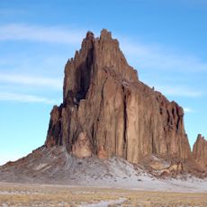
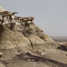
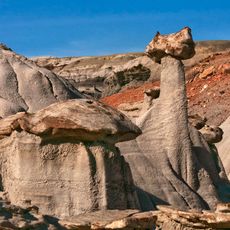
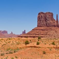
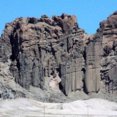
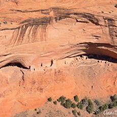
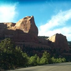
Roof Butte is the highest summit in the Chuska Mountains range, located within Navajo Nation territory in Arizona. The peak features distinctive volcanic formations that shape its flat-topped surface and are visible from long distances.

History

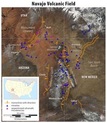
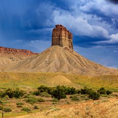
The mountain formed through volcanic activity, with two funnel-shaped explosion pipes and a lava dome creating its distinctive structure. This geological history shaped the landscape and remains visible in the peak's composition today.

Culture

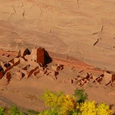
The mountain carries the Navajo name Adáá dikʼá, which reflects the deep connection of Navajo people to this land and their territories. Visitors walking the summit experience a place that holds meaning across generations for the communities who live here.

Practical

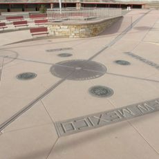
Access to the summit is provided by Indian Route 68, which leads directly to the peak. A lookout tower at the top offers vantage points for viewing the landscape stretching across the Arizona-New Mexico border region.

Did you know?

The summit has an unusually flat surface created by volcanic formations underneath. This distinctive shape makes it visible from considerable distances and contributes to its recognizable appearance across the landscape.

Location
GPS coordinates
36.46051,-109.09367
Latest update
December 12, 2025 14:20

AroundUs brings together thousands of curated places, local tips, and hidden gems, enriched daily by 60,000 contributors worldwide. Discover all places nearby (Arizona).

Around this place
Four Corners Monument
United States of America

Four Corners Monument

60.1 km
Shiprock
United States of America

Shiprock

34.2 km
Bisti/De-Na-Zin Wilderness
United States of America

Bisti/De-Na-Zin Wilderness

89.1 km
Kirtland Formation
United States of America

Kirtland Formation

72 km
Navajo Nation Council Chamber
United States of America

Navajo Nation Council Chamber

87 km
Navajo Nation Zoological and Botanical Park
United States of America

Navajo Nation Zoological and Botanical Park

88.7 km
Fruitland Formation
United States of America

Fruitland Formation

66.7 km
Navajo Nation Museum
United States of America

Navajo Nation Museum

88.7 km
Navajo section
United States of America

Navajo section

36.6 km
Farmington Public Library
United States of America

Farmington Public Library

87.9 km
Chimney Rock
United States of America

Chimney Rock

76.4 km
Cathedral Cliff
United States of America

Cathedral Cliff

38.3 km
Farmington Historic Downtown Commercial District
United States of America

Farmington Historic Downtown Commercial District

84.8 km
House of Many Windows
United States of America

House of Many Windows

95.4 km
San Juan River Bridge at Shiprock
United States of America

San Juan River Bridge at Shiprock

50.6 km
White House Ruins
United States of America

White House Ruins

49.6 km
Square Tower House
United States of America

Square Tower House

95.1 km
Long House
United States of America

Long House

94.9 km
Kodak House
United States of America

Kodak House

94.2 km
Mummy Cave Ruins
United States of America

Mummy Cave Ruins

34.6 km
Buffalo Pass
United States of America

Buffalo Pass

5 km
Navajo Nation Museum
United States of America

Navajo Nation Museum

88.7 km
Antelope House
United States of America

Antelope House

46.2 km
Hubbell Home
United States of America

Hubbell Home

93.5 km
Window Rock
United States of America

Window Rock

86.7 km
Nokaito Bench
United States of America

Nokaito Bench

81.6 km
Cliff Canyon
United States of America

Cliff Canyon

95.2 km
Canyon de Chelly National Monument Visitor Center
United States of America

Canyon de Chelly National Monument Visitor Center

52.6 km
Show the full map
« Roof Butte - Mountain summit in Navajo Nation, Arizona, USA » is provided by Around Us (aroundus.com). Images and texts are derived from Wikimedia project under a Creative Commons license. You are allowed to copy, distribute, and modify copies of this page, under the conditions set by the license, as long as this note is clearly visible.

Discover hidden gems everywhere you go!

From secret cafés to breathtaking viewpoints, skip the crowded tourist spots and find places that match your style. Our app makes it easy with voice search, smart filtering, route optimization, and insider tips from travelers worldwide. Download now for the complete mobile experience.

Around Us App Screenshot

A unique approach to discovering new places

Le Figaro

All the places worth exploring

France Info

A tailor-made excursion in just a few clicks

20 Minutes

Around Us
Travel Guide & Maps
Download

Send to your phone

QR Code
1

Open the camera app on your mobile.

2

Point at the QR code with your camera. A notification will appear.

3

Tap the notification to open the link.