Newspaper Rock State Historic Monument
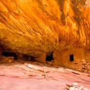
Newspaper Rock State Historic Monument, Petroglyphic site in San Juan County, United States
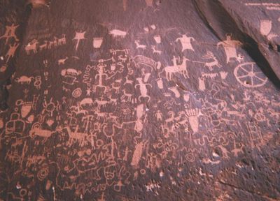
The 200-square-foot rock panel displays over 650 carved petroglyphs featuring human figures, animals, and geometric patterns on dark desert-varnished Wingate sandstone.
Native Americans from different cultures, including Archaic, Anasazi, Fremont, and Navajo people, created these rock carvings between 2000 years ago and the early 1900s.
The site, named Tse Hone in Navajo language, contains numerous depictions of daily life, including hunting scenes, territorial markings, and representations of spiritual beliefs.
Located 28 miles northwest of Monticello along Utah State Route 211, the monument offers a paved parking area and viewing platform with spotting scopes.
The rock surface contains multiple petroglyphs showing polydactyly, a genetic condition where individuals have extra fingers or toes, suggesting its prevalence in ancient communities.
Location: San Juan County
GPS coordinates: 37.98806,-109.51833
Latest update: May 27, 2025 13:20
Utah preserves thousands of years of human history alongside some of North America's most varied geological landscapes. The region contains extensive rock art panels and Ancestral Pueblo ruins, including the 13th-century stone structures at Bears Ears National Monument and the 650-plus petroglyphs carved into Newspaper Rock over two millennia. Fremont Indian State Park displays more than 1,000 artifacts from the indigenous peoples who inhabited these lands, while fossilized dinosaur tracks near Moab record the passage of Allosaurus and Diplodocus across ancient mudflats 150 million years ago. The natural environment ranges from the sculpted sandstone formations of Goblin Valley, where erosion has created mushroom-shaped rocks rising 20 feet (6 meters) from the desert floor, to the narrow passages of Kanarra Creek Canyon with its red walls and cascading waterfalls. The Wedge Overlook reveals 1,000-foot (300-meter) cliffs above the San Rafael River, while Monroe's thermal springs emerge from the ground at 110°F (43°C). Whether exploring slot canyons, examining ancient handprints on rock walls, or walking among eroded sandstone formations, visitors encounter landscapes that document both geological processes spanning millions of years and the enduring presence of human cultures in this high desert region.
Church Rock
18 km
Wilson Arch
34.2 km
Druid Arch
29.8 km
Sixshooter Peaks
21.2 km
Angel Arch
21.9 km
Abajo Peak
17.3 km
Alkali Ridge
30.2 km
Kirk's Cabin Complex
19.8 km
Cave Springs Cowboy Camp
27.8 km
Stillwater Canyon
39.3 km
Lost Canyon Cowboy Camp
26.8 km
Frederick Isaac and Mary M. Jones House
20.4 km
Paul Bunyans Potty
24.2 km
Wooden Shoe Arch
28.3 km
Elephant Hill Trailhead
32 km
The Needles Visitor Center
29.1 km
Joint Trail
33.1 km
The Needles Overlook
35.9 km
North Sixshooter Peak
21.2 km
Chesler Park
32.3 km
South Sixshooter Peak
18.8 km
The Needles
32.8 km
Looking Glass Rock
33.5 km
The Needles
29.2 km
Keyhole Ruins
23.4 km
Angel Arch
22.1 km
Paul Bunyans Potty Arch
24.2 km
Fortress Arch
20.8 kmReviews
Visited this place? Tap the stars to rate it and share your experience / photos with the community! Try now! You can cancel it anytime.
Discover hidden gems everywhere you go!
From secret cafés to breathtaking viewpoints, skip the crowded tourist spots and find places that match your style. Our app makes it easy with voice search, smart filtering, route optimization, and insider tips from travelers worldwide. Download now for the complete mobile experience.
A unique approach to discovering new places❞
— Le Figaro
All the places worth exploring❞
— France Info
A tailor-made excursion in just a few clicks❞
— 20 Minutes