See the monuments around you in AROpen chests in the app
Around Us is built for your phone — point your camera at the streets and discover the monuments and places around you in augmented reality.Around Us is built for your phone — chests unlock when you walk, explore and capture nearby places.
Natural monuments in Utah: archaeological sites, rock formations, thermal springs
Utah preserves thousands of years of human history alongside some of North America's most varied geological landscapes. The region contains extensive rock art panels and Ancestral Pueblo ruins, including the 13th-century stone structures at Bears Ears National Monument and the 650-plus petroglyphs carved into Newspaper Rock over two millennia. Fremont Indian State Park displays more than 1,000 artifacts from the indigenous peoples who inhabited these lands, while fossilized dinosaur tracks near Moab record the passage of Allosaurus and Diplodocus across ancient mudflats 150 million years ago.
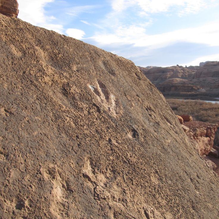
The natural environment ranges from the sculpted sandstone formations of Goblin Valley, where erosion has created mushroom-shaped rocks rising 20 feet (6 meters) from the desert floor, to the narrow passages of Kanarra Creek Canyon with its red walls and cascading waterfalls. The Wedge Overlook reveals 1,000-foot (300-meter) cliffs above the San Rafael River, while Monroe's thermal springs emerge from the ground at 110°F (43°C). Whether exploring slot canyons, examining ancient handprints on rock walls, or walking among eroded sandstone formations, visitors encounter landscapes that document both geological processes spanning millions of years and the enduring presence of human cultures in this high desert region.
Natural monuments in Utah: archaeological sites, rock formations, thermal springs
Utah preserves thousands of years of human history alongside some of North America's most varied geological landscapes. The region contains extensive rock art panels and Ancestral Pueblo ruins, including the 13th-century stone structures at Bears Ears National Monument and the 650-plus petroglyphs carved into Newspaper Rock over two millennia. Fremont Indian State Park displays more than 1,000 artifacts from the indigenous peoples who inhabited these lands, while fossilized dinosaur tracks near Moab record the passage of Allosaurus and Diplodocus across ancient mudflats 150 million years ago.
The natural environment ranges from the sculpted sandstone formations of Goblin Valley, where erosion has created mushroom-shaped rocks rising 20 feet (6 meters) from the desert floor, to the narrow passages of Kanarra Creek Canyon with its red walls and cascading waterfalls. The Wedge Overlook reveals 1,000-foot (300-meter) cliffs above the San Rafael River, while Monroe's thermal springs emerge from the ground at 110°F (43°C). Whether exploring slot canyons, examining ancient handprints on rock walls, or walking among eroded sandstone formations, visitors encounter landscapes that document both geological processes spanning millions of years and the enduring presence of human cultures in this high desert region.
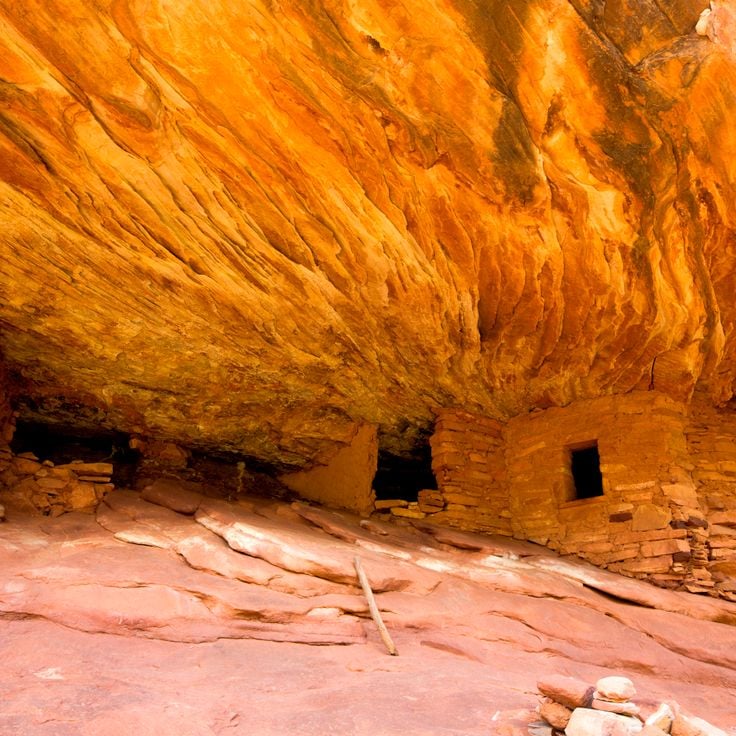
These ruins within Bears Ears National Monument are part of Utah's collection of archaeological sites and display 13th-century stone structures built by the Ancestral Pueblo people. The construction methods and settlement patterns of the period remain visible in the preserved walls. The reddish rocks of the surrounding landscape create a warm contrast with the prehistoric structures and produce distinctive color effects under direct sunlight. The ruins occupy a remote area of the monument and document the early human occupation of the region.
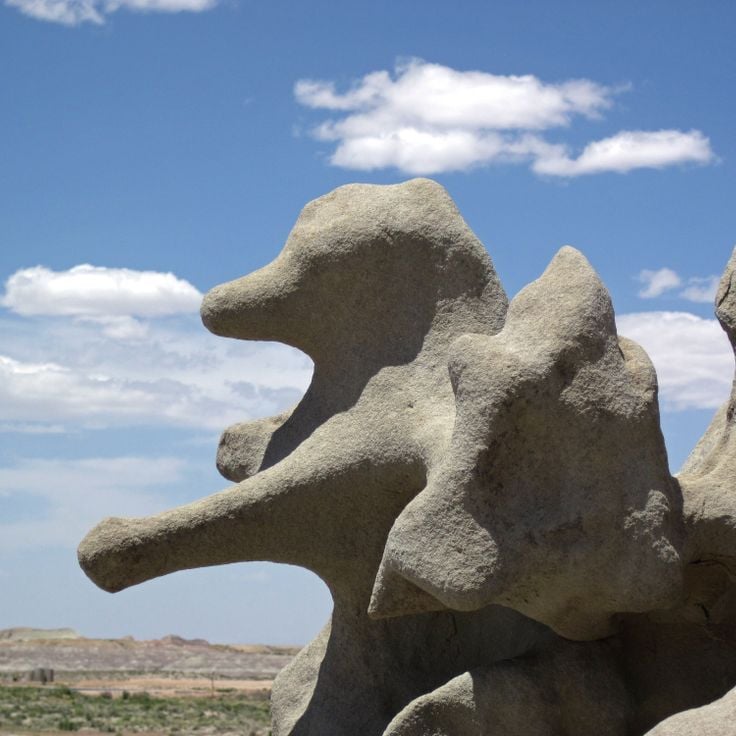
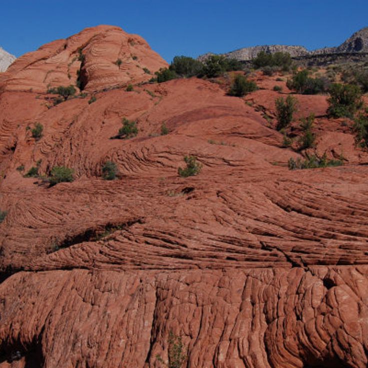
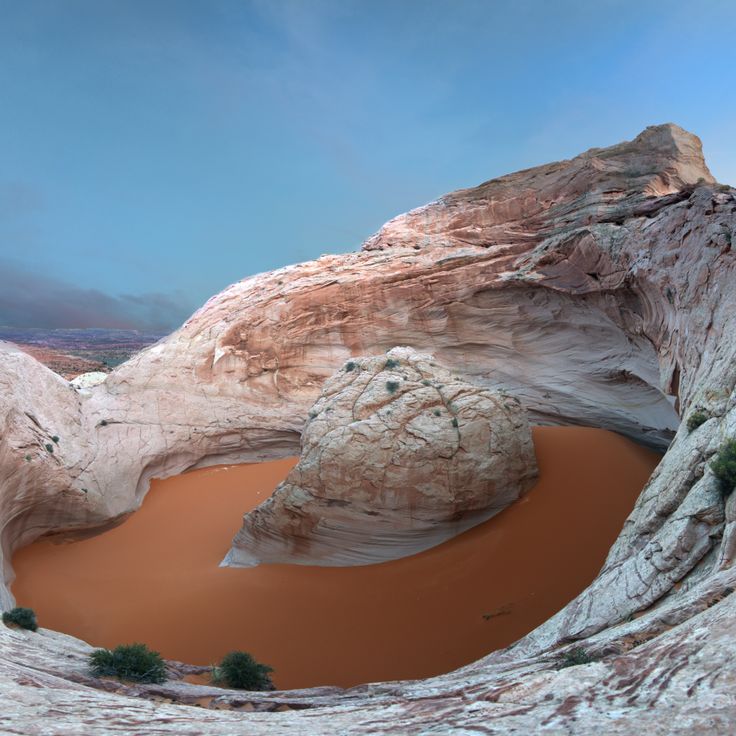
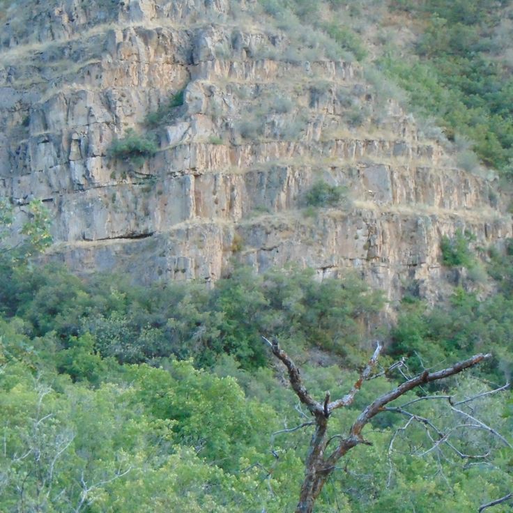
This gray sandstone formation in Uintah County shows millions of years of geological history. Wind and water have carved various shapes into the rock over time. The layered walls reveal how natural forces have shaped this landscape. The canyon fits within Utah's collection of natural monuments, which preserves rock art, petroglyphs, and traces of Pueblo cultures.
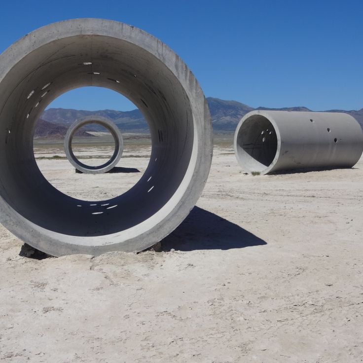
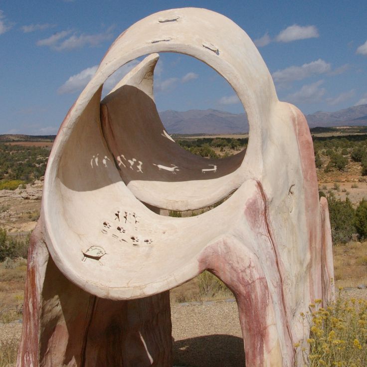
This art installation in the Great Basin Desert complements Utah's rich collection of ancient archaeology and natural stone formations by introducing a contemporary creative work to the high desert landscape. Four concrete tubes, each measuring 18 feet (5.5 meters) long, are positioned to capture sunlight during sunrise and sunset. The installation adds a modern artistic perspective to a region shaped by thousands of years of human presence and millions of years of geological change.
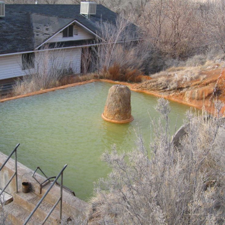
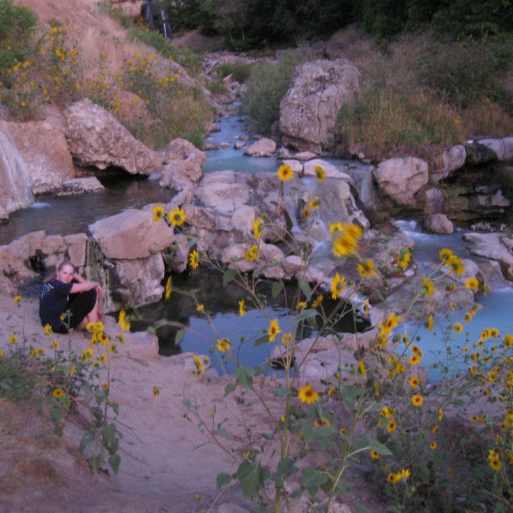
The Monroe Thermal Springs are a historic thermal facility from the 19th century located in a region of Utah known for its geological formations and archaeological sites. The mineral water at this spring reaches a temperature of 43 degrees Celsius. The facility preserves bathtubs from its founding era and demonstrates the long history of how people have used natural resources in this high desert region.
Goblin Valley is located within this state park and showcases sandstone formations that resemble figures. These geological structures rise up to 20 feet (6 meters) from the desert floor and formed through erosion over millions of years. The area lies within the San Rafael Desert and offers access to these unusual rock formations, characterized by their mushroom-shaped forms. Walking among these eroded stones reveals how wind and water have sculpted the landscape into distinctive shapes.
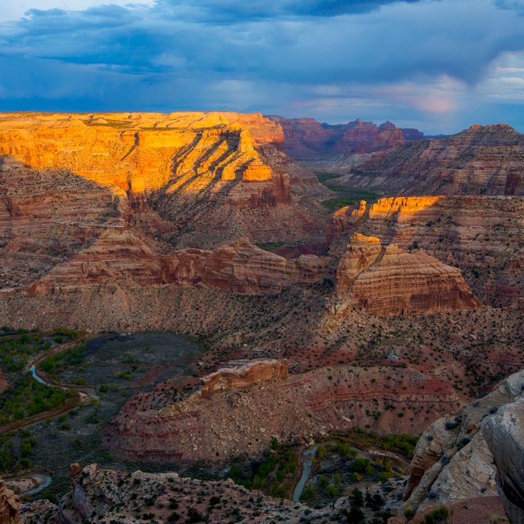
The Wedge Overlook provides a stunning view of the San Rafael River flowing 300 meters below through red sandstone formations. This viewpoint at San Rafael Swell connects geological structures shaped over millions of years with the archaeological significance of the region, including rock art and Pueblo culture remnants. The layered cliffs reveal how wind and water have carved the landscape throughout geological time.
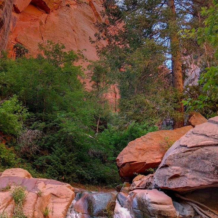
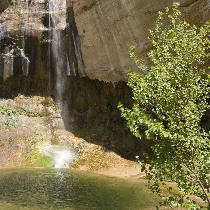
Kanarra Creek Canyon is a narrow gorge with red sandstone walls through which a stream flows. The water forms two waterfalls, each about 13 feet high. This canyon lies within Utah's geologically varied region and displays the sandstone formations typical of the area. The streambed winds through tight passages between the rock walls. The canyon sits within a landscape that preserves thousands of years of human history alongside striking geological formations.
This rock wall along Potash Road preserves footprints from Allosaurus and Diplodocus dinosaurs that walked across ancient mudflats 150 million years ago. The fossilized tracks appear on a sandstone surface and document the movement of these dinosaurs during the Jurassic period. The site sits roadside and offers direct access to these paleontological remains, which are part of the Morrison Formation and show what prehistoric life looked like in this region.
The Fremont Indian State Park and Museum contains one of the largest collections of Fremont artifacts from the indigenous cultures that inhabited Utah's high desert for six centuries. The museum displays over 1000 objects including tools, pottery, and basketry that show how people hunted, farmed, and crafted items for daily use. Rock art panels with petroglyphs and pictographs remain visible along the park's hiking trails, created by these people between 700 and 1300 AD. Walking through this park allows visitors to see both the objects they made and the images they carved into stone.
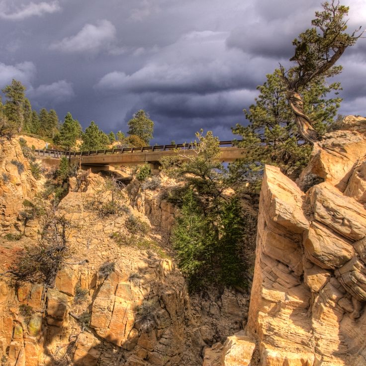
The Hell's Backbone Bridge was built in 1933 to connect steep rock walls in this region. This wooden structure crosses the canyon and provides access to remote areas of the landscape. The bridge forms part of a historic route through the sandstone formations and offers views of the surrounding canyons and geological structures of Utah, which document thousands of years of human history and diverse geological landscapes.
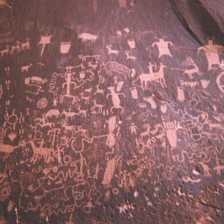
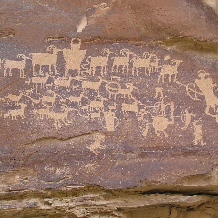
Newspaper Rock in Bears Ears National Monument displays more than 650 petroglyphs carved over 2,000 years by the region's indigenous peoples. The rock art features human figures, animals, and geometric patterns etched into dark sandstone. These carvings provide a record of the societies that inhabited the Colorado Plateau, from ancient cultures through Pueblo peoples. The site sits within a larger landscape holding numerous archaeological remains and cultural sites spanning millennia.
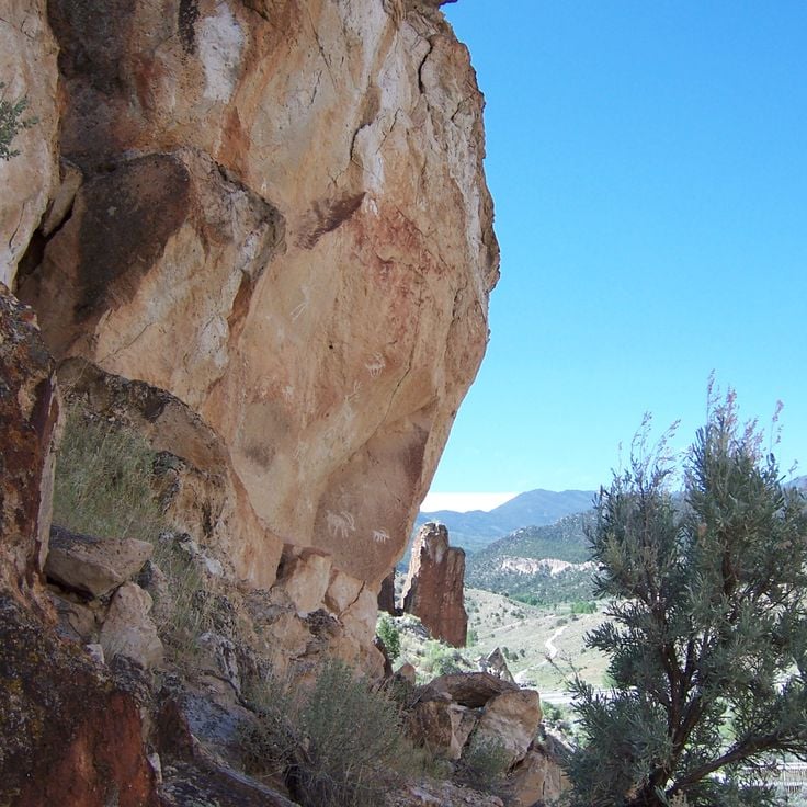
The petroglyphs of Snow Canyon State Park were created by Anasazi and Paiute tribes between 300 and 1100 AD. Carved into dark basalt rocks, these images show geometric patterns, human figures, and animals. They tell the story of the spiritual beliefs and daily life of the people who lived here long ago. The rock art sits along several trails that wind through volcanic terrain and red sandstone formations, offering visitors a direct connection to the ancient cultures that shaped this desert region.
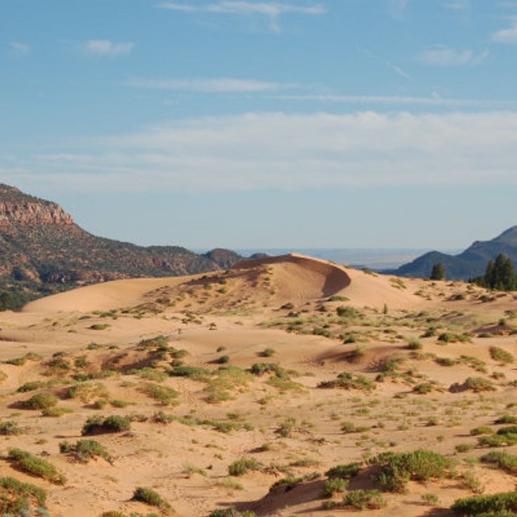
Coral Pink Sand Dunes State Park is part of Utah's diverse landscape, where archaeological sites and natural formations tell stories of human presence and geological time. The park's sand dunes formed through erosion of Navajo sandstone, their red and pink colors coming from iron oxide in the rock. Trails wind through the dunes and lead to remote areas where visitors can see traces of Pueblo cultures, walk among the sculpted formations, and experience the layered history that defines this high desert region.
Grand Staircase-Escalante National Monument, United States
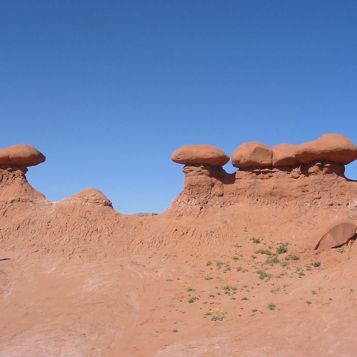
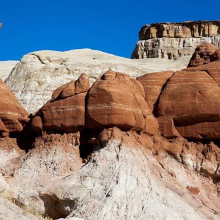
The Toadstool Hoodoos in this National Monument are rock spires with balanced capstones created through differential erosion. Dakota sandstone erodes faster than the harder rock above it, resulting in mushroom-shaped structures with broad caps resting on narrow stems. These geological formations are located in the Paria Rimrocks and demonstrate how different rock layers weather at different rates. The hoodoos are part of the monument's varied rock landscape and offer insights into the geological processes shaping Utah's high desert.
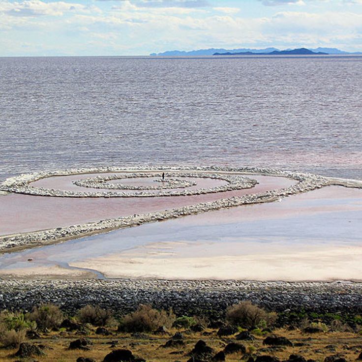
The Spiral Jetty is an earthwork created in 1970 that extends approximately 1,500 feet from the shore of the Great Salt Lake into the water, forming a counterclockwise spiral. Constructed from black basalt rock sourced from the surrounding area, this artwork integrates into the landscape of salt deposits and rock formations. The structure's visibility changes with the lake's water levels. As part of Utah's collection of natural monuments and human artifacts, the Spiral Jetty demonstrates how artistic creation interacts with geological processes in this high desert region.
The Cosmic Ashtray is a geological formation in Garfield County within this collection of Utah's natural monuments. This basin displays black sand and walls of orange Navajo sandstone, recording the erosion processes that have shaped the sandstone formations of this region over millions of years. Located in a remote area, the formation is part of Utah's varied landscape that brings together geological structures with archaeological sites from Pueblo cultures.
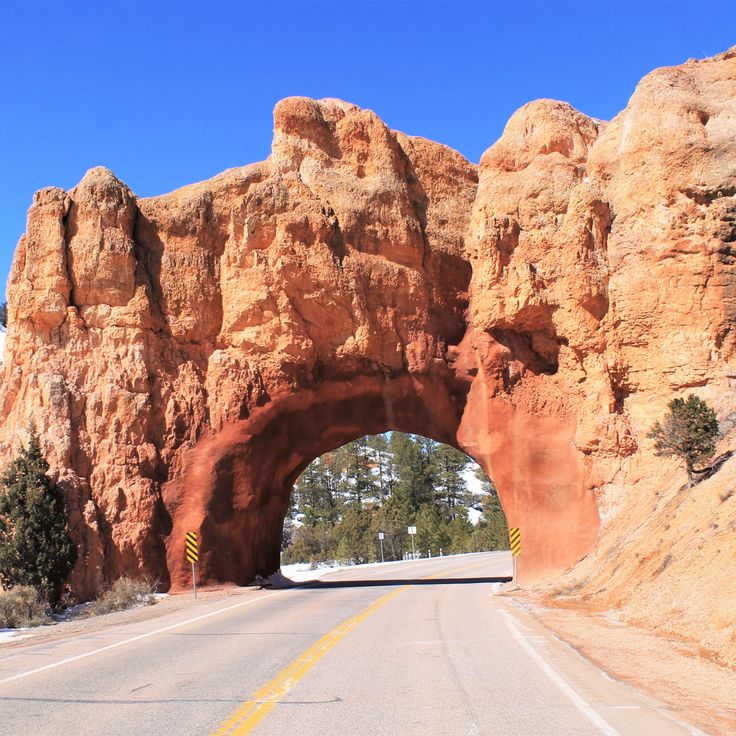
The Red Canyon Road Tunnels in Panguitch are two passages carved through red sandstone in 1929 that connect sections of Scenic Route 12. These tunnels allow travel through the canyon's geological formations and represent how people built roads through Utah's sandstone landscapes. The tunnels provide access to the region's natural structures within a landscape that documents thousands of years of human history and varied geological processes.
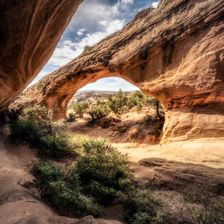
Moonshine Rock Arch stands near Vernal as part of Utah's varied geological landscapes. This sandstone formation developed over millions of years through wind and water erosion, displaying the stone structures typical of the region. The arch rises about 26 meters tall with a span of about 40 meters. A 5-kilometer trail leads from the trailhead to the formation, crossing desert terrain dotted with juniper and sagebrush. Moonshine Rock Arch sits on the Colorado Plateau, an area known for its numerous natural arches and geological formations.
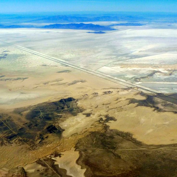
Bonneville Salt Lake is a vast white expanse of salt that formed when a prehistoric lake evaporated over millions of years. The ground consists of sodium chloride and offers an exceptionally level surface. This salt flat has become famous as a location for land speed record attempts. The site preserves traces of ancient Lake Bonneville, which once covered much of what is now Utah.
Maple Canyon is part of Utah's geological heritage and features conglomerate rock from the Cretaceous period. The canyon walls are composed of cemented pebbles that have been pressed together over millions of years. The rock formations here attract climbers from across the region.
Nine Mile Canyon contains over 1000 documented rock art panels from the Fremont culture dating from 300 to 1300 CE. The petroglyphs and pictographs depict hunting scenes, anthropomorphic figures, and geometric patterns carved into the canyon walls. This canyon provides access to prehistoric dwellings and granaries built into the rock. Nine Mile Canyon combines natural sandstone formations with archaeological evidence of the people who lived in this high desert region.
The museum at Edge of the Cedars State Park displays artifacts from the Anasazi of the Utah region, including pottery, tools, and textiles. A restored 12th-century kiva provides insight into the ceremonies of Pueblo culture. The museum documents the archaeological history of the Four Corners region and presents findings from nearby excavation sites, connecting visitors to thousands of years of human presence in this desert landscape.
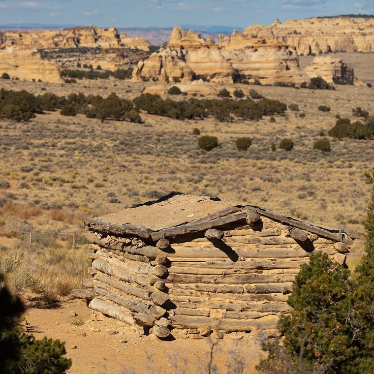
This wooden cabin built in 1921 housed cattle ranchers working in the San Rafael Desert. Standing at 1500 meters elevation among sandstone formations, the structure shows how ranchers lived and worked in this remote region during the early 1900s. The cabin documents the daily life of desert ranchers and sits in an area that also preserves ancient rock carvings and Ancestral Pueblo remains.
Goosenecks State Park is located in southern Utah, where the San Juan River has carved more than 1,000 feet (300 meters) into the rock formations. This park demonstrates the power of water erosion through three consecutive river loops that have cut through the bedrock over millions of years. The overlooks provide views of the canyon and the winding waterways, which are part of Utah's natural landscape.
Upper Calf Creek Falls is an 88-foot waterfall that drops over red sandstone into a natural pool. Located in Calf Creek Canyon in southern Utah, this waterfall is part of the region's varied geological landscapes shaped by water and erosion over millions of years. A hiking trail leads through the desert terrain to reach the falls, passing through typical sandstone formations of the area. The pool at the base of the falls offers a place to rest among the sculpted rocks.
Fifth Water Hot Springs are natural thermal pools in the Uinta National Forest that belong to Utah's collection of geological and cultural treasures. The mineral-rich water emerges from underground at temperatures between 38 and 43 degrees Celsius (100 to 109 degrees Fahrenheit) and collects in several pools of different sizes. A hiking trail through forested terrain leads visitors to the springs, following alongside a creek. These thermal features showcase the geological processes that have shaped this high desert region for millions of years and complement the area's Ancestral Pueblo ruins and rock formations.
Upheaval Dome in Canyonlands National Park is a crater roughly 5 miles (3 kilometers) across featuring concentric rings of rock. This geological formation resulted from either a meteorite impact or the movement of salt deposits deep beneath the surface. The structure displays multiple layers of sandstone that have been pushed upward and contorted from inside the crater. Walking around this site, visitors encounter evidence of the powerful forces that have shaped Utah's landscape over millions of years.
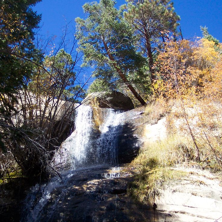
Singletree Falls in the Uinta Mountains is a natural feature that reflects Utah's geological heritage. Water descends over granite rocks and flows through pine forests at this elevation. The falls represent the water-shaped landscapes characteristic of this region, situated in an area marked by the presence of Pueblo culture and the human history preserved across Utah's natural environment.
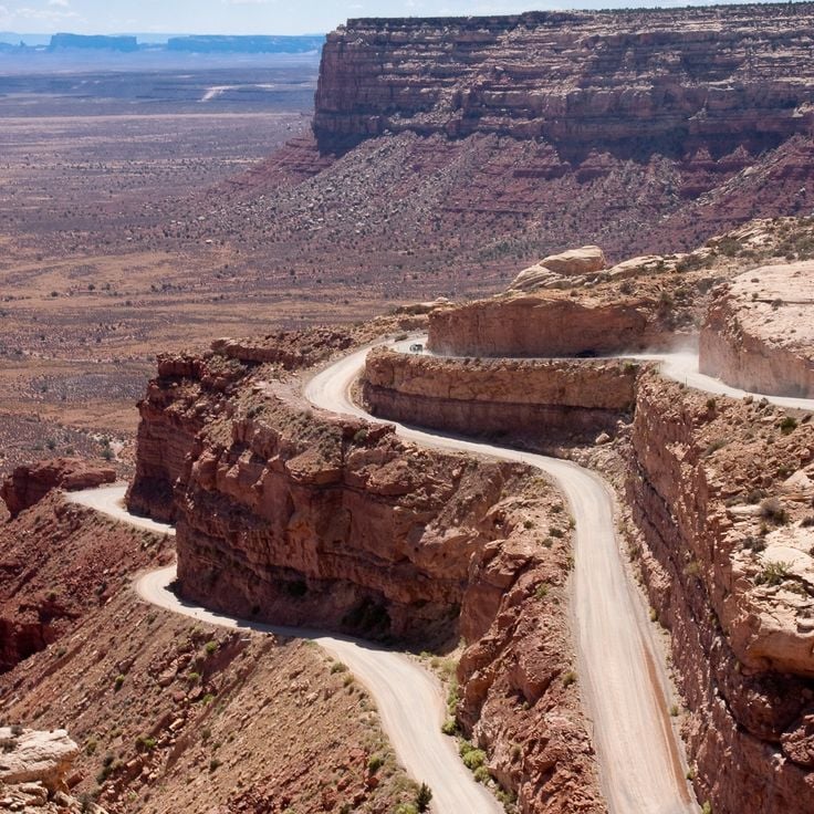
The Moki Dugway is a dirt mountain road that descends from Cedar Mesa, dropping more than 360 meters in elevation. This road connects the high plateau with the Valley of the Gods, and along the way reveals the different layers of sandstone formations that document the geological history of this region. Originally constructed for uranium mining, the route passes through a landscape of red rock formations that exemplify the varied geological landscapes preserved throughout Utah.
Grand Staircase-Escalante National Monument, United States
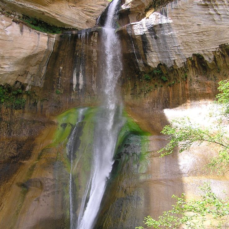
Lower Calf Creek Falls is a 130-foot waterfall in Grand Staircase-Escalante National Monument. A 3-mile trail through the canyon leads to the falls. The path follows Calf Creek and passes rock art panels and sandstone formations. The pool at the base of the falls is fed by the creek. This site lets you explore the geological processes that shaped Utah over millions of years while discovering traces of human cultures in this high desert region.
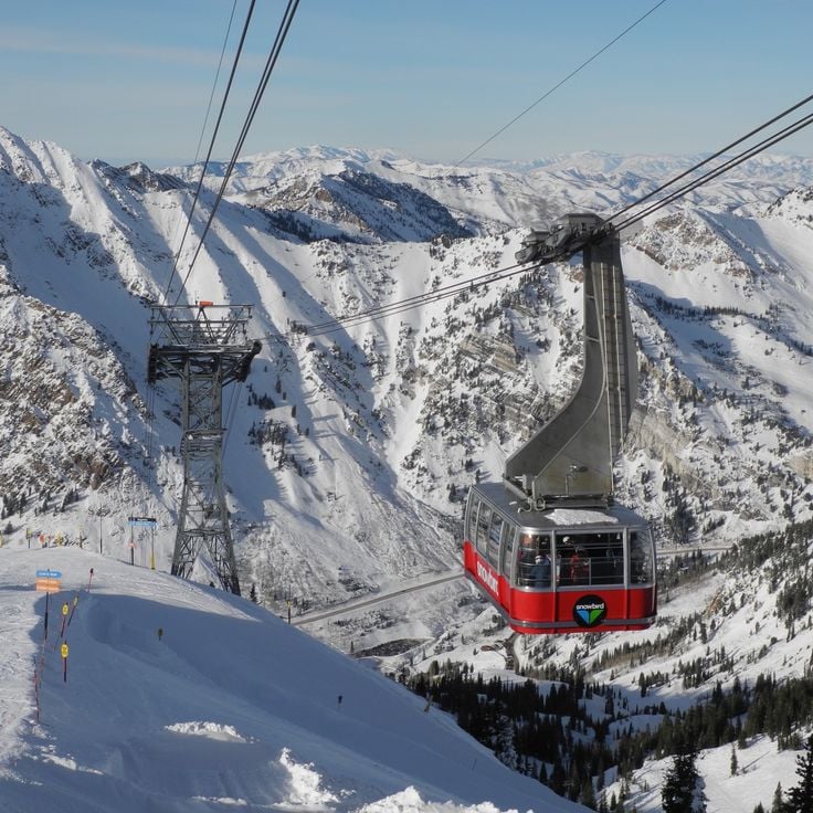
Hidden Peak in Snowbird rises to 11,000 feet and provides views across the Wasatch Range and Salt Lake Valley. This summit lies in northern Utah and can be reached through hiking trails or the Snowbird aerial tram. The mountain area shows alpine vegetation and rock formations of metamorphic and igneous origin. During winter months, this location serves as a ski area with steep descents. The surroundings document the geological formation of the Wasatch mountain chain through tectonic activity. The peak allows observation of the surrounding mountain terrain and valley basin.
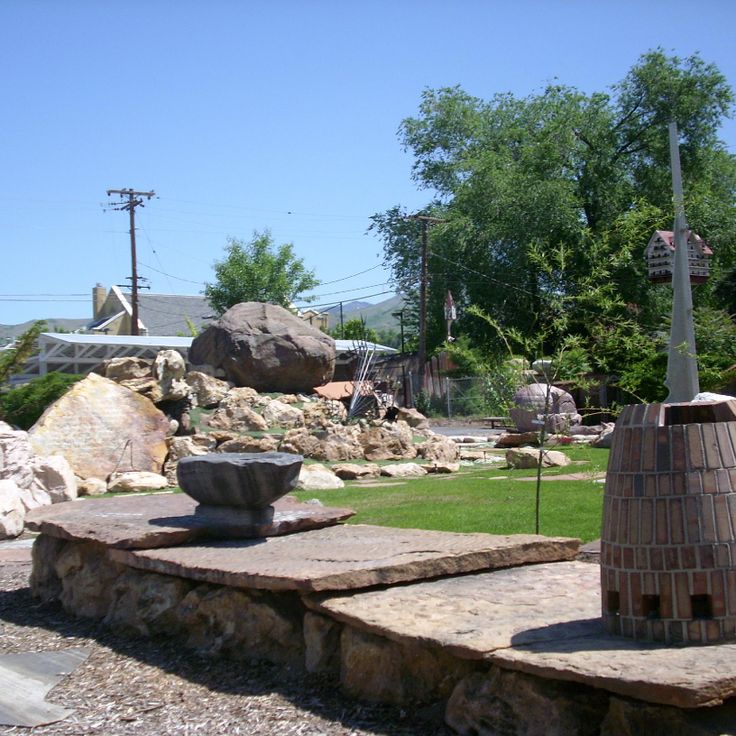
Gilgal Sculpture Garden is a municipal park in Salt Lake City showcasing Utah's artistic and spiritual heritage. The garden displays 12 original stone sculptures and over 70 inscribed stones created between 1945 and 1963 by Thomas Battersby Child. His work combines religious themes with personal visions, representing a distinctive form of American folk art. The sculptures depict biblical figures and symbolic representations, while engraved stones carry quotations from religious texts. The garden documents how a Mormon bishop transformed his property into a spiritual artwork reflecting both faith and creativity.
These ruins within Bears Ears National Monument are part of Utah's collection of archaeological sites and display 13th-century stone structures built by the Ancestral Pueblo people. The construction methods and settlement patterns of the period remain visible in the preserved walls. The reddish rocks of the surrounding landscape create a warm contrast with the prehistoric structures and produce distinctive color effects under direct sunlight. The ruins occupy a remote area of the monument and document the early human occupation of the region.
This gray sandstone formation in Uintah County shows millions of years of geological history. Wind and water have carved various shapes into the rock over time. The layered walls reveal how natural forces have shaped this landscape. The canyon fits within Utah's collection of natural monuments, which preserves rock art, petroglyphs, and traces of Pueblo cultures.
This art installation in the Great Basin Desert complements Utah's rich collection of ancient archaeology and natural stone formations by introducing a contemporary creative work to the high desert landscape. Four concrete tubes, each measuring 18 feet (5.5 meters) long, are positioned to capture sunlight during sunrise and sunset. The installation adds a modern artistic perspective to a region shaped by thousands of years of human presence and millions of years of geological change.
The Monroe Thermal Springs are a historic thermal facility from the 19th century located in a region of Utah known for its geological formations and archaeological sites. The mineral water at this spring reaches a temperature of 43 degrees Celsius. The facility preserves bathtubs from its founding era and demonstrates the long history of how people have used natural resources in this high desert region.
Goblin Valley is located within this state park and showcases sandstone formations that resemble figures. These geological structures rise up to 20 feet (6 meters) from the desert floor and formed through erosion over millions of years. The area lies within the San Rafael Desert and offers access to these unusual rock formations, characterized by their mushroom-shaped forms. Walking among these eroded stones reveals how wind and water have sculpted the landscape into distinctive shapes.
The Wedge Overlook provides a stunning view of the San Rafael River flowing 300 meters below through red sandstone formations. This viewpoint at San Rafael Swell connects geological structures shaped over millions of years with the archaeological significance of the region, including rock art and Pueblo culture remnants. The layered cliffs reveal how wind and water have carved the landscape throughout geological time.
Kanarra Creek Canyon is a narrow gorge with red sandstone walls through which a stream flows. The water forms two waterfalls, each about 13 feet high. This canyon lies within Utah's geologically varied region and displays the sandstone formations typical of the area. The streambed winds through tight passages between the rock walls. The canyon sits within a landscape that preserves thousands of years of human history alongside striking geological formations.
This rock wall along Potash Road preserves footprints from Allosaurus and Diplodocus dinosaurs that walked across ancient mudflats 150 million years ago. The fossilized tracks appear on a sandstone surface and document the movement of these dinosaurs during the Jurassic period. The site sits roadside and offers direct access to these paleontological remains, which are part of the Morrison Formation and show what prehistoric life looked like in this region.
The Fremont Indian State Park and Museum contains one of the largest collections of Fremont artifacts from the indigenous cultures that inhabited Utah's high desert for six centuries. The museum displays over 1000 objects including tools, pottery, and basketry that show how people hunted, farmed, and crafted items for daily use. Rock art panels with petroglyphs and pictographs remain visible along the park's hiking trails, created by these people between 700 and 1300 AD. Walking through this park allows visitors to see both the objects they made and the images they carved into stone.
The Hell's Backbone Bridge was built in 1933 to connect steep rock walls in this region. This wooden structure crosses the canyon and provides access to remote areas of the landscape. The bridge forms part of a historic route through the sandstone formations and offers views of the surrounding canyons and geological structures of Utah, which document thousands of years of human history and diverse geological landscapes.
Newspaper Rock in Bears Ears National Monument displays more than 650 petroglyphs carved over 2,000 years by the region's indigenous peoples. The rock art features human figures, animals, and geometric patterns etched into dark sandstone. These carvings provide a record of the societies that inhabited the Colorado Plateau, from ancient cultures through Pueblo peoples. The site sits within a larger landscape holding numerous archaeological remains and cultural sites spanning millennia.
The petroglyphs of Snow Canyon State Park were created by Anasazi and Paiute tribes between 300 and 1100 AD. Carved into dark basalt rocks, these images show geometric patterns, human figures, and animals. They tell the story of the spiritual beliefs and daily life of the people who lived here long ago. The rock art sits along several trails that wind through volcanic terrain and red sandstone formations, offering visitors a direct connection to the ancient cultures that shaped this desert region.
Coral Pink Sand Dunes State Park is part of Utah's diverse landscape, where archaeological sites and natural formations tell stories of human presence and geological time. The park's sand dunes formed through erosion of Navajo sandstone, their red and pink colors coming from iron oxide in the rock. Trails wind through the dunes and lead to remote areas where visitors can see traces of Pueblo cultures, walk among the sculpted formations, and experience the layered history that defines this high desert region.
Grand Staircase-Escalante National Monument, United States
The Toadstool Hoodoos in this National Monument are rock spires with balanced capstones created through differential erosion. Dakota sandstone erodes faster than the harder rock above it, resulting in mushroom-shaped structures with broad caps resting on narrow stems. These geological formations are located in the Paria Rimrocks and demonstrate how different rock layers weather at different rates. The hoodoos are part of the monument's varied rock landscape and offer insights into the geological processes shaping Utah's high desert.
The Spiral Jetty is an earthwork created in 1970 that extends approximately 1,500 feet from the shore of the Great Salt Lake into the water, forming a counterclockwise spiral. Constructed from black basalt rock sourced from the surrounding area, this artwork integrates into the landscape of salt deposits and rock formations. The structure's visibility changes with the lake's water levels. As part of Utah's collection of natural monuments and human artifacts, the Spiral Jetty demonstrates how artistic creation interacts with geological processes in this high desert region.
The Cosmic Ashtray is a geological formation in Garfield County within this collection of Utah's natural monuments. This basin displays black sand and walls of orange Navajo sandstone, recording the erosion processes that have shaped the sandstone formations of this region over millions of years. Located in a remote area, the formation is part of Utah's varied landscape that brings together geological structures with archaeological sites from Pueblo cultures.
The Red Canyon Road Tunnels in Panguitch are two passages carved through red sandstone in 1929 that connect sections of Scenic Route 12. These tunnels allow travel through the canyon's geological formations and represent how people built roads through Utah's sandstone landscapes. The tunnels provide access to the region's natural structures within a landscape that documents thousands of years of human history and varied geological processes.
Moonshine Rock Arch stands near Vernal as part of Utah's varied geological landscapes. This sandstone formation developed over millions of years through wind and water erosion, displaying the stone structures typical of the region. The arch rises about 26 meters tall with a span of about 40 meters. A 5-kilometer trail leads from the trailhead to the formation, crossing desert terrain dotted with juniper and sagebrush. Moonshine Rock Arch sits on the Colorado Plateau, an area known for its numerous natural arches and geological formations.
Bonneville Salt Lake is a vast white expanse of salt that formed when a prehistoric lake evaporated over millions of years. The ground consists of sodium chloride and offers an exceptionally level surface. This salt flat has become famous as a location for land speed record attempts. The site preserves traces of ancient Lake Bonneville, which once covered much of what is now Utah.
Maple Canyon is part of Utah's geological heritage and features conglomerate rock from the Cretaceous period. The canyon walls are composed of cemented pebbles that have been pressed together over millions of years. The rock formations here attract climbers from across the region.
Nine Mile Canyon contains over 1000 documented rock art panels from the Fremont culture dating from 300 to 1300 CE. The petroglyphs and pictographs depict hunting scenes, anthropomorphic figures, and geometric patterns carved into the canyon walls. This canyon provides access to prehistoric dwellings and granaries built into the rock. Nine Mile Canyon combines natural sandstone formations with archaeological evidence of the people who lived in this high desert region.
The museum at Edge of the Cedars State Park displays artifacts from the Anasazi of the Utah region, including pottery, tools, and textiles. A restored 12th-century kiva provides insight into the ceremonies of Pueblo culture. The museum documents the archaeological history of the Four Corners region and presents findings from nearby excavation sites, connecting visitors to thousands of years of human presence in this desert landscape.
This wooden cabin built in 1921 housed cattle ranchers working in the San Rafael Desert. Standing at 1500 meters elevation among sandstone formations, the structure shows how ranchers lived and worked in this remote region during the early 1900s. The cabin documents the daily life of desert ranchers and sits in an area that also preserves ancient rock carvings and Ancestral Pueblo remains.
Goosenecks State Park is located in southern Utah, where the San Juan River has carved more than 1,000 feet (300 meters) into the rock formations. This park demonstrates the power of water erosion through three consecutive river loops that have cut through the bedrock over millions of years. The overlooks provide views of the canyon and the winding waterways, which are part of Utah's natural landscape.
Upper Calf Creek Falls is an 88-foot waterfall that drops over red sandstone into a natural pool. Located in Calf Creek Canyon in southern Utah, this waterfall is part of the region's varied geological landscapes shaped by water and erosion over millions of years. A hiking trail leads through the desert terrain to reach the falls, passing through typical sandstone formations of the area. The pool at the base of the falls offers a place to rest among the sculpted rocks.
Fifth Water Hot Springs are natural thermal pools in the Uinta National Forest that belong to Utah's collection of geological and cultural treasures. The mineral-rich water emerges from underground at temperatures between 38 and 43 degrees Celsius (100 to 109 degrees Fahrenheit) and collects in several pools of different sizes. A hiking trail through forested terrain leads visitors to the springs, following alongside a creek. These thermal features showcase the geological processes that have shaped this high desert region for millions of years and complement the area's Ancestral Pueblo ruins and rock formations.
Upheaval Dome in Canyonlands National Park is a crater roughly 5 miles (3 kilometers) across featuring concentric rings of rock. This geological formation resulted from either a meteorite impact or the movement of salt deposits deep beneath the surface. The structure displays multiple layers of sandstone that have been pushed upward and contorted from inside the crater. Walking around this site, visitors encounter evidence of the powerful forces that have shaped Utah's landscape over millions of years.
Singletree Falls in the Uinta Mountains is a natural feature that reflects Utah's geological heritage. Water descends over granite rocks and flows through pine forests at this elevation. The falls represent the water-shaped landscapes characteristic of this region, situated in an area marked by the presence of Pueblo culture and the human history preserved across Utah's natural environment.
The Moki Dugway is a dirt mountain road that descends from Cedar Mesa, dropping more than 360 meters in elevation. This road connects the high plateau with the Valley of the Gods, and along the way reveals the different layers of sandstone formations that document the geological history of this region. Originally constructed for uranium mining, the route passes through a landscape of red rock formations that exemplify the varied geological landscapes preserved throughout Utah.
Grand Staircase-Escalante National Monument, United States
Lower Calf Creek Falls is a 130-foot waterfall in Grand Staircase-Escalante National Monument. A 3-mile trail through the canyon leads to the falls. The path follows Calf Creek and passes rock art panels and sandstone formations. The pool at the base of the falls is fed by the creek. This site lets you explore the geological processes that shaped Utah over millions of years while discovering traces of human cultures in this high desert region.
Hidden Peak in Snowbird rises to 11,000 feet and provides views across the Wasatch Range and Salt Lake Valley. This summit lies in northern Utah and can be reached through hiking trails or the Snowbird aerial tram. The mountain area shows alpine vegetation and rock formations of metamorphic and igneous origin. During winter months, this location serves as a ski area with steep descents. The surroundings document the geological formation of the Wasatch mountain chain through tectonic activity. The peak allows observation of the surrounding mountain terrain and valley basin.
Gilgal Sculpture Garden is a municipal park in Salt Lake City showcasing Utah's artistic and spiritual heritage. The garden displays 12 original stone sculptures and over 70 inscribed stones created between 1945 and 1963 by Thomas Battersby Child. His work combines religious themes with personal visions, representing a distinctive form of American folk art. The sculptures depict biblical figures and symbolic representations, while engraved stones carry quotations from religious texts. The garden documents how a Mormon bishop transformed his property into a spiritual artwork reflecting both faith and creativity.