Hidden Peak

Log in to your account

AroundUs is a community-driven map of interesting places, built by curious explorers like you. It grows with every review, story, and photo you share.
Connect to save your favorite spots, contribute locations, and create personalized routes.
Continue with Google
Continue with Apple
Continue with X
Continue with Facebook
Continue with email
By continuing, you accept our Terms and Conditions and our Privacy Policy
Create an account
Add to collection
Map
Suggest a change
Share

Hidden Peak, Mountain summit in Little Cottonwood Canyon, United States

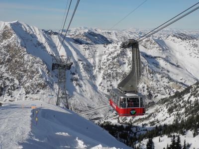
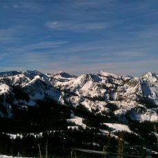
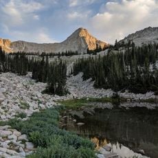
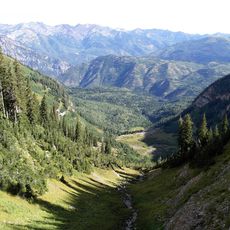
Hidden Peak is a mountain summit in the Wasatch Range rising to approximately 11,000 feet above Little Cottonwood Canyon. From the top, you can see across multiple surrounding ridges and into the deep canyon below, with views extending across the broader mountain landscape.

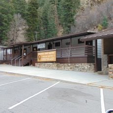
Ski facilities developed on the peak in the mid-20th century, transforming the area into a major winter sports location. This development brought competition events and regular visitors to the mountain.

The mountain draws photographers and nature enthusiasts throughout the seasons, with winter bringing ski competitions and summer offering hiking opportunities for outdoor recreation.

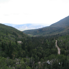
You can reach the summit via the Snowbird aerial tram or hiking trails that range in difficulty and steepness. Seasonal conditions significantly affect trail conditions and how long the journey takes.

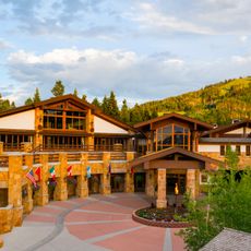
The peak features plans for a substantial 50,000-square-foot facility including a convention center, dining venues, and entertainment spaces at its summit location.

Location: Utah County

GPS coordinates: 40.56079,-111.64507

Latest update: December 6, 2025 19:09

Photos
Natural monuments in Utah: archaeological sites, rock formations, thermal springs

Utah preserves thousands of years of human history alongside some of North America's most varied geological landscapes. The region contains extensive rock art panels and Ancestral Pueblo ruins, including the 13th-century stone structures at Bears Ears National Monument and the 650-plus petroglyphs...

Around this place
Timpanogos Cave National Monument
United States of America

Timpanogos Cave National Monument

14.5 km
Little Cottonwood Canyon
United States of America

Little Cottonwood Canyon

5.4 km
Big Cottonwood Canyon
United States of America

Big Cottonwood Canyon

9.7 km
Mount Olympus
United States of America

Mount Olympus

15.1 km
Pfeifferhorn
United States of America

Pfeifferhorn

6 km
Lone Peak
United States of America

Lone Peak

10.1 km
Stein Eriksen Lodge Botanical Garden
United States of America

Stein Eriksen Lodge Botanical Garden

14.6 km
Cottonwood Paper Mill
United States of America

Cottonwood Paper Mill

15 km
Wasatch Mountain State Park
United States of America

Wasatch Mountain State Park

11.2 km
Cecret Lake
United States of America

Cecret Lake

2.2 km
Doughnut Falls
United States of America

Doughnut Falls

7.8 km
Lone Peak Wilderness
United States of America

Lone Peak Wilderness

4.4 km
Stairs Station Hydroelectric Power Plant Historic District
United States of America

Stairs Station Hydroelectric Power Plant Historic District

11 km
Moyle House and Indian Tower
United States of America

Moyle House and Indian Tower

14.8 km
Timpanogos Cave Historic District
United States of America

Timpanogos Cave Historic District

14.4 km
Granite Hydroelectric Power Plant Historic District
United States of America

Granite Hydroelectric Power Plant Historic District

13.2 km
Granite LDS Ward Chapel-Avard Fairbanks Studio
United States of America

Granite LDS Ward Chapel-Avard Fairbanks Studio

13.6 km
Upper American Fork Hydroelectric Power Plant Historic District
United States of America

Upper American Fork Hydroelectric Power Plant Historic District

15.2 km
Timpanogos Cave National Monument Visitor Center
United States of America

Timpanogos Cave National Monument Visitor Center

14 km
Albion Basin
United States of America

Albion Basin

2.9 km
Tibble Fork Reservoir
United States of America

Tibble Fork Reservoir

9 km
Silver Lake Flat Reservoir
United States of America

Silver Lake Flat Reservoir

6.5 km
Maybird Gulch
United States of America

Maybird Gulch

5.6 km
Silver Lake
United States of America

Silver Lake

6.8 km
Bells Canyon
United States of America

Bells Canyon

13.7 km
Giant Staircase
United States of America

Giant Staircase

14.2 km
Red Pine Lake
United States of America

Red Pine Lake

4.5 km
Upper Bells Canyon Reservoir
United States of America

Upper Bells Canyon Reservoir

8.5 km
Show the full map
Reviews

Visited this place? Tap the stars to rate it and share your experience / photos with the community! Try now! You can cancel it anytime.

« Hidden Peak - Mountain summit in Little Cottonwood Canyon, United States » is provided by Around Us (aroundus.com). Images and texts are derived from Wikimedia project under a Creative Commons license. You are allowed to copy, distribute, and modify copies of this page, under the conditions set by the license, as long as this note is clearly visible.

Discover hidden gems everywhere you go!

From secret cafés to breathtaking viewpoints, skip the crowded tourist spots and find places that match your style. Our app makes it easy with voice search, smart filtering, route optimization, and insider tips from travelers worldwide. Download now for the complete mobile experience.

Around Us App Screenshot

A unique approach to discovering new places

Le Figaro

All the places worth exploring

France Info

A tailor-made excursion in just a few clicks

20 Minutes