Enable Location

We need your location to show you interesting places around you

Discover nearby places

Find interesting locations and hidden gems around you

Precise directions

Get accurate directions and distances to places

Your location is never shared with other users. It's only used when you tap the location button.

Little Cottonwood Canyon

Log in to your account

Start exploring — it's free

Trusted by 62,238 travelers worldwide

Continue with Google
Continue with Apple
or

We will send you a code to connect

By continuing, you accept our Terms and Conditions and our Privacy Policy

Check your inbox

We've sent a pincode in your inbox. Please enter the code below.

Little Cottonwood Canyon

Little Cottonwood Canyon, Canyon in Salt Lake County, US.

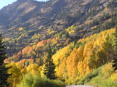
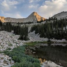
Little Cottonwood Canyon is a steep valley in the Wasatch Range with dramatic granite walls on either side of a flowing creek. The narrow passage widens in places to reveal meadows and dense forests of pine and aspen, with the landscape becoming more sparse and rocky at higher elevations.

Silver deposits discovered in the 1800s brought mining camps and mills throughout the canyon, with Alta becoming a significant mining town. When silver demand declined, the area transitioned to recreation and skiing, though remnants of mine tailings and old structures remain visible in some sections.

The canyon's name traces back to the Ute word for the fine fiber from the cottonwood tree, reflecting the plant life that shaped early settlements in the region. People today notice this heritage when walking through groves that still dot the streamside and in the way visitors find quiet spots beneath towering rock faces.

The main road up the canyon is open during warmer months but typically closed in winter due to heavy snow. Day trips work well for hiking, though higher elevations get cold quickly, so warm layers and sturdy shoes are worth bringing year-round.

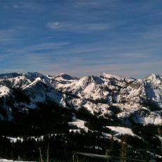
The canyon receives more snow in a year than almost anywhere else in North America, fueling two major ski resorts that have operated there for decades. This abundance of snow makes for excellent skiing but also means most trails become impassable for much of the winter season.

The community of curious travelers

AroundUs brings together thousands of curated places, local tips, and hidden gems, enriched daily by 60,000 contributors worldwide.

Start exploring
Location
Elevation above the sea
1,566 m
GPS coordinates
40.57100,-111.70700
Latest update
December 7, 2025 10:07
Around this place
Big Cottonwood Canyon
United States of America

Big Cottonwood Canyon

7.9 km
Mount Olympus
United States of America

Mount Olympus

11 km
Pfeifferhorn
United States of America

Pfeifferhorn

4.2 km
Lone Peak
United States of America

Lone Peak

6.4 km
Cottonwood Paper Mill
United States of America

Cottonwood Paper Mill

10 km
Cecret Lake
United States of America

Cecret Lake

7.2 km
Doughnut Falls
United States of America

Doughnut Falls

8 km
Lone Peak Wilderness
United States of America

Lone Peak Wilderness

4.7 km
Stairs Station Hydroelectric Power Plant Historic District
United States of America

Stairs Station Hydroelectric Power Plant Historic District

6.8 km
Moyle House and Indian Tower
United States of America

Moyle House and Indian Tower

12.9 km
Granite Hydroelectric Power Plant Historic District
United States of America

Granite Hydroelectric Power Plant Historic District

8.2 km
Granite LDS Ward Chapel-Avard Fairbanks Studio
United States of America

Granite LDS Ward Chapel-Avard Fairbanks Studio

8.2 km
Perry and Agnes Wadsworth Fitzgerald House
United States of America

Perry and Agnes Wadsworth Fitzgerald House

13.6 km
Glen M. and Roxie Walbeck House
United States of America

Glen M. and Roxie Walbeck House

13.4 km
Mary Smith House
United States of America

Mary Smith House

13 km
Lauritz H. and Emma Smith House
United States of America

Lauritz H. and Emma Smith House

12.9 km
Brady-Brady House
United States of America

Brady-Brady House

13.4 km
Harold W. and Evelyn Burton House
United States of America

Harold W. and Evelyn Burton House

13.8 km
Lauritz Smith House
United States of America

Lauritz Smith House

13.2 km
Albion Basin
United States of America

Albion Basin

7.5 km
Tibble Fork Reservoir
United States of America

Tibble Fork Reservoir

11.4 km
Silver Lake
United States of America

Silver Lake

10.7 km
Silver Lake Flat Reservoir
United States of America

Silver Lake Flat Reservoir

8.7 km
Maybird Gulch
United States of America

Maybird Gulch

367 m
Bells Canyon
United States of America

Bells Canyon

8.4 km
Red Pine Lake
United States of America

Red Pine Lake

3.3 km
Neffs Canyon
United States of America

Neffs Canyon

13 km
Hidden Peak
United States of America

Hidden Peak

5.4 km
Show the full map
« Little Cottonwood Canyon - Canyon in Salt Lake County, US » is provided by Around Us (aroundus.com). Images and texts are derived from Wikimedia project under a Creative Commons license. You are allowed to copy, distribute, and modify copies of this page, under the conditions set by the license, as long as this note is clearly visible.

Discover hidden gems everywhere you go!

From secret cafés to breathtaking viewpoints, skip the crowded tourist spots and find places that match your style. Our app makes it easy with voice search, smart filtering, route optimization, and insider tips from travelers worldwide. Download now for the complete mobile experience.

Around Us App Screenshot

A unique approach to discovering new places

Le Figaro

All the places worth exploring

France Info

A tailor-made excursion in just a few clicks

20 Minutes

Around Us
Travel Guide & Maps
Download

Send to your phone

QR Code
1

Open the camera app on your mobile.

2

Point at the QR code with your camera. A notification will appear.

3

Tap the notification to open the link.