Pfeifferhorn

Log in to your account

AroundUs is a community-driven map of interesting places, built by curious explorers like you. It grows with every review, story, and photo you share.
Connect to save your favorite spots, contribute locations, and create personalized routes.
Continue with Google
Continue with Apple
Continue with X
Continue with Facebook
Continue with email
By continuing, you accept our Terms and Conditions and our Privacy Policy
Create an account
Add to collection
Map
Suggest a change
Share

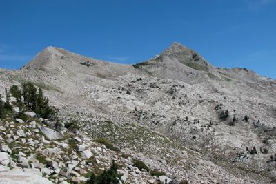
Pfeifferhorn, Mountain summit in Little Cottonwood Canyon, United States.

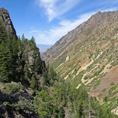
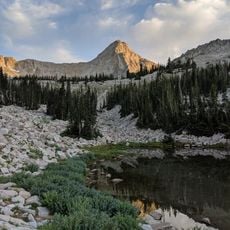
Pfeifferhorn is a distinctive peak in the Wasatch Range with steep slopes and granite formations near its summit. The upper reaches feature rocky structures that define the challenging terrain climbers encounter.

The mountain received its official name in 2013 to honor Charles Pfeiffer, a climber whose legacy began when his ashes were scattered on the summit decades earlier. This naming recognizes his early connection to the peak.

The peak draws serious hikers and climbers who seek a challenging adventure in the Wasatch Range. It has become a destination where outdoor enthusiasts gather to test their skills on steep terrain.

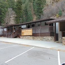
Access starts at the White Pine Trailhead parking area, which fills quickly on popular days. The route demands solid fitness and climbing experience, especially on the upper sections with exposed rock.

Mountain goats make their home in the area above Red Pine Lake and often appear along the climbing route. From the summit, climbers look out across Mount Timpanogos and the Utah Valley below.

Location: Salt Lake County

GPS coordinates: 40.53354,-111.70598

Latest update: December 10, 2025 16:03

Photos
Around this place
Timpanogos Cave National Monument
United States of America

Timpanogos Cave National Monument

10.4 km
Little Cottonwood Canyon
United States of America

Little Cottonwood Canyon

4.2 km
Big Cottonwood Canyon
United States of America

Big Cottonwood Canyon

12 km
American Fork Canyon
United States of America

American Fork Canyon

11.4 km
Lone Peak
United States of America

Lone Peak

4.3 km
Cecret Lake
United States of America

Cecret Lake

8.2 km
Doughnut Falls
United States of America

Doughnut Falls

11.7 km
Lone Peak Wilderness
United States of America

Lone Peak Wilderness

1.9 km
Stairs Station Hydroelectric Power Plant Historic District
United States of America

Stairs Station Hydroelectric Power Plant Historic District

10.7 km
Moyle House and Indian Tower
United States of America

Moyle House and Indian Tower

9.2 km
Timpanogos Cave Historic District
United States of America

Timpanogos Cave Historic District

10.2 km
Granite Hydroelectric Power Plant Historic District
United States of America

Granite Hydroelectric Power Plant Historic District

11.5 km
Alpine City Hall
United States of America

Alpine City Hall

10.7 km
Granite LDS Ward Chapel-Avard Fairbanks Studio
United States of America

Granite LDS Ward Chapel-Avard Fairbanks Studio

9.4 km
Glen M. and Roxie Walbeck House
United States of America

Glen M. and Roxie Walbeck House

12.2 km
Mary Smith House
United States of America

Mary Smith House

12 km
Upper American Fork Hydroelectric Power Plant Historic District
United States of America

Upper American Fork Hydroelectric Power Plant Historic District

10.8 km
Lauritz H. and Emma Smith House
United States of America

Lauritz H. and Emma Smith House

12 km
Lauritz Smith House
United States of America

Lauritz Smith House

12.3 km
Timpanogos Cave National Monument Visitor Center
United States of America

Timpanogos Cave National Monument Visitor Center

10 km
Albion Basin
United States of America

Albion Basin

8.8 km
Tibble Fork Reservoir
United States of America

Tibble Fork Reservoir

7.9 km
Silver Lake Flat Reservoir
United States of America

Silver Lake Flat Reservoir

5.4 km
Maybird Gulch
United States of America

Maybird Gulch

4 km
Red Pine Lake
United States of America

Red Pine Lake

1.5 km
Bells Canyon
United States of America

Bells Canyon

9.3 km
Hidden Peak
United States of America

Hidden Peak

6 km
Upper Bells Canyon Reservoir
United States of America

Upper Bells Canyon Reservoir

3.2 km
Show the full map
Reviews

Visited this place? Tap the stars to rate it and share your experience / photos with the community! Try now! You can cancel it anytime.

« Pfeifferhorn - Mountain summit in Little Cottonwood Canyon, United States » is provided by Around Us (aroundus.com). Images and texts are derived from Wikimedia project under a Creative Commons license. You are allowed to copy, distribute, and modify copies of this page, under the conditions set by the license, as long as this note is clearly visible.

Discover hidden gems everywhere you go!

From secret cafés to breathtaking viewpoints, skip the crowded tourist spots and find places that match your style. Our app makes it easy with voice search, smart filtering, route optimization, and insider tips from travelers worldwide. Download now for the complete mobile experience.

Around Us App Screenshot

A unique approach to discovering new places

Le Figaro

All the places worth exploring

France Info

A tailor-made excursion in just a few clicks

20 Minutes