Enable Location

We need your location to show you interesting places around you

Discover nearby places

Find interesting locations and hidden gems around you

Precise directions

Get accurate directions and distances to places

Your location is never shared with other users. It's only used when you tap the location button.

Doughnut Falls

Log in to your account

Start exploring — it's free

Trusted by 62,248 travelers worldwide

Continue with Google
Continue with Apple
or

We will send you a code to connect

By continuing, you accept our Terms and Conditions and our Privacy Policy

Check your inbox

We've sent a pincode in your inbox. Please enter the code below.

Doughnut Falls

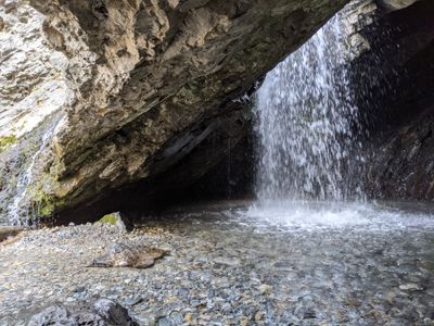
Doughnut Falls, Mountain waterfall in Big Cottonwood Canyon, United States.

Doughnut Falls is a waterfall in Big Cottonwood Canyon where water plunges through a distinctive circular rock opening into a pool below. The natural hole in the stone formation creates an unusual visual effect that changes throughout the seasons.

The waterfall became part of the Wasatch-Cache National Forest trail system as the region developed its hiking network during the mid-20th century. The rock formation itself was shaped by natural geological processes over thousands of years.

Local families and youth groups gather at this waterfall throughout summer months, maintaining a tradition of outdoor recreation in Utah's mountain areas.

The waterfall is reached via a hiking trail that takes two to three hours round-trip with moderate uphill walking. Parking at the trailhead is limited, so arriving early is advisable, especially on weekends.

During winter months the water freezes into ice columns that resemble natural sculptures, completely transforming the site's appearance. These frozen formations occur only under specific weather conditions and attract photographers.

The community of curious travelers

AroundUs brings together thousands of curated places, local tips, and hidden gems, enriched daily by 60,000 contributors worldwide.

Start exploring
GPS coordinates
40.63092,-111.65451
Latest update
December 10, 2025 20:07
Around this place
Little Cottonwood Canyon
United States of America

Little Cottonwood Canyon

8 km
Big Cottonwood Canyon
United States of America

Big Cottonwood Canyon

3.1 km
Mount Olympus
United States of America

Mount Olympus

10.3 km
Pfeifferhorn
United States of America

Pfeifferhorn

11.7 km
Cottonwood Paper Mill
United States of America

Cottonwood Paper Mill

12.2 km
Mill Creek Canyon
United States of America

Mill Creek Canyon

12.8 km
Cecret Lake
United States of America

Cecret Lake

7.3 km
Lone Peak Wilderness
United States of America

Lone Peak Wilderness

11.1 km
Stairs Station Hydroelectric Power Plant Historic District
United States of America

Stairs Station Hydroelectric Power Plant Historic District

7.6 km
Glenwood Cemetery
United States of America

Glenwood Cemetery

12.3 km
Joe Quinney Winter Sports Center
United States of America

Joe Quinney Winter Sports Center

11.9 km
Granite Hydroelectric Power Plant Historic District
United States of America

Granite Hydroelectric Power Plant Historic District

10.8 km
Park City High School Mechanical Arts Building
United States of America

Park City High School Mechanical Arts Building

13 km
Samuel D. Walker House
United States of America

Samuel D. Walker House

13.1 km
Burt Kimball House
United States of America

Burt Kimball House

13.2 km
Charles Meadowcroft House
United States of America

Charles Meadowcroft House

13.2 km
James Cavanaugh House
United States of America

James Cavanaugh House

13.3 km
Henry M. Hinsdill House
United States of America

Henry M. Hinsdill House

13.3 km
Peter Farthelos House
United States of America

Peter Farthelos House

13.2 km
McPolin Farmstead
United States of America

McPolin Farmstead

12 km
St. Mary of the Assumption Church
United States of America

St. Mary of the Assumption Church

11.4 km
Albion Basin
United States of America

Albion Basin

6.7 km
Silver Lake
United States of America

Silver Lake

6.3 km
Maybird Gulch
United States of America

Maybird Gulch

8.4 km
Neffs Canyon
United States of America

Neffs Canyon

11.4 km
Red Pine Lake
United States of America

Red Pine Lake

10.3 km
Hidden Peak
United States of America

Hidden Peak

7.8 km
Upper Bells Canyon Reservoir
United States of America

Upper Bells Canyon Reservoir

12.4 km
Show the full map
« Doughnut Falls - Mountain waterfall in Big Cottonwood Canyon, United States » is provided by Around Us (aroundus.com). Images and texts are derived from Wikimedia project under a Creative Commons license. You are allowed to copy, distribute, and modify copies of this page, under the conditions set by the license, as long as this note is clearly visible.

Discover hidden gems everywhere you go!

From secret cafés to breathtaking viewpoints, skip the crowded tourist spots and find places that match your style. Our app makes it easy with voice search, smart filtering, route optimization, and insider tips from travelers worldwide. Download now for the complete mobile experience.

Around Us App Screenshot

A unique approach to discovering new places

Le Figaro

All the places worth exploring

France Info

A tailor-made excursion in just a few clicks

20 Minutes

Around Us
Travel Guide & Maps
Download

Send to your phone

QR Code
1

Open the camera app on your mobile.

2

Point at the QR code with your camera. A notification will appear.

3

Tap the notification to open the link.