Lone Peak Wilderness

Log in to your account

AroundUs is a community-driven map of interesting places, built by curious explorers like you. It grows with every review, story, and photo you share.
Connect to save your favorite spots, contribute locations, and create personalized routes.
Continue with Google
Continue with Apple
Continue with X
Continue with Facebook
Continue with email
By continuing, you accept our Terms and Conditions and our Privacy Policy
Create an account
Add to collection
Map
Suggest a change
Share

Lone Peak Wilderness, Protected mountain area in Utah County and Salt Lake County, United States.

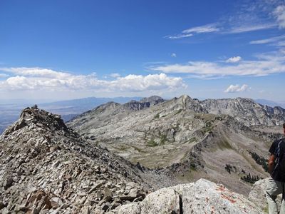
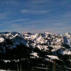
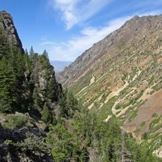
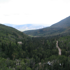
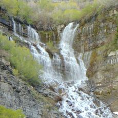
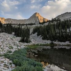
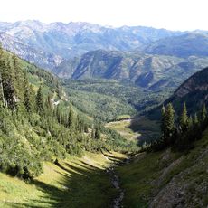
Lone Peak Wilderness is a protected mountain area spanning across the Uinta and Wasatch-Cache National Forests with alpine lakes, dense conifer forests, and sharp granite peaks. The landscape transitions between open ridges and forested valleys filled with streams and rock formations.

Congress designated this wilderness area in 1978 as part of the Endangered American Wilderness Act, protecting it from development. The designation marked one of the first formal conservation efforts for Utah's alpine landscape.

The mountains served for generations as hunting grounds for Ute and Shoshone peoples who traveled through the high valleys and peaks. Visitors today walk through landscapes shaped by centuries of Indigenous use and presence.

Bring navigation tools like a map and compass since GPS becomes unreliable at higher elevations and in canyons. Expect snow on trails into mid-summer and plan for limited or no cell phone coverage once you leave lower areas.

Two peaks exceed 11,000 feet: Pfeifferhorn at 11,326 feet and Lone Peak at 11,253 feet, rising prominently above surrounding ridges. These distinctive summits serve as landmarks visible from many approach routes and define the wilderness skyline.

Location: Utah County

Location: Salt Lake County

Elevation above the sea: 2,518 m

GPS coordinates: 40.53330,-111.68300

Latest update: December 11, 2025 18:05

Photos
Around this place
Timpanogos Cave National Monument
United States of America

Timpanogos Cave National Monument

10.6 km
Little Cottonwood Canyon
United States of America

Little Cottonwood Canyon

4.7 km
Big Cottonwood Canyon
United States of America

Big Cottonwood Canyon

12 km
American Fork Canyon
United States of America

American Fork Canyon

11.9 km
Pfeifferhorn
United States of America

Pfeifferhorn

1.9 km
Lone Peak
United States of America

Lone Peak

6.2 km
Wasatch Mountain State Park
United States of America

Wasatch Mountain State Park

12.8 km
Cecret Lake
United States of America

Cecret Lake

6.6 km
Doughnut Falls
United States of America

Doughnut Falls

11.1 km
Stairs Station Hydroelectric Power Plant Historic District
United States of America

Stairs Station Hydroelectric Power Plant Historic District

11.5 km
Moyle House and Indian Tower
United States of America

Moyle House and Indian Tower

10.4 km
Timpanogos Cave Historic District
United States of America

Timpanogos Cave Historic District

10.5 km
Granite Hydroelectric Power Plant Historic District
United States of America

Granite Hydroelectric Power Plant Historic District

12.7 km
Alpine City Hall
United States of America

Alpine City Hall

11.9 km
Granite LDS Ward Chapel-Avard Fairbanks Studio
United States of America

Granite LDS Ward Chapel-Avard Fairbanks Studio

11.2 km
Upper American Fork Hydroelectric Power Plant Historic District
United States of America

Upper American Fork Hydroelectric Power Plant Historic District

11.2 km
Scout Falls
United States of America

Scout Falls

13.4 km
Timpanogos Cave National Monument Visitor Center
United States of America

Timpanogos Cave National Monument Visitor Center

10.1 km
Albion Basin
United States of America

Albion Basin

7.3 km
Tibble Fork Reservoir
United States of America

Tibble Fork Reservoir

6.7 km
Silver Lake Flat Reservoir
United States of America

Silver Lake Flat Reservoir

4 km
Maybird Gulch
United States of America

Maybird Gulch

4.6 km
Silver Lake
United States of America

Silver Lake

11.2 km
Bells Canyon
United States of America

Bells Canyon

11.1 km
Giant Staircase
United States of America

Giant Staircase

11.8 km
Red Pine Lake
United States of America

Red Pine Lake

1.4 km
Hidden Peak
United States of America

Hidden Peak

4.4 km
Upper Bells Canyon Reservoir
United States of America

Upper Bells Canyon Reservoir

5.1 km
Show the full map
Reviews

Visited this place? Tap the stars to rate it and share your experience / photos with the community! Try now! You can cancel it anytime.

« Lone Peak Wilderness - Protected mountain area in Utah County and Salt Lake County, United States » is provided by Around Us (aroundus.com). Images and texts are derived from Wikimedia project under a Creative Commons license. You are allowed to copy, distribute, and modify copies of this page, under the conditions set by the license, as long as this note is clearly visible.

Discover hidden gems everywhere you go!

From secret cafés to breathtaking viewpoints, skip the crowded tourist spots and find places that match your style. Our app makes it easy with voice search, smart filtering, route optimization, and insider tips from travelers worldwide. Download now for the complete mobile experience.

Around Us App Screenshot

A unique approach to discovering new places

Le Figaro

All the places worth exploring

France Info

A tailor-made excursion in just a few clicks

20 Minutes