Enable Location

We need your location to show you interesting places around you

Discover nearby places

Find interesting locations and hidden gems around you

Precise directions

Get accurate directions and distances to places

Your location is never shared with other users. It's only used when you tap the location button.

Cecret Lake

Log in to your account

Start exploring — it's free

Trusted by 62,248 travelers worldwide

Continue with Google
Continue with Apple
or

We will send you a code to connect

By continuing, you accept our Terms and Conditions and our Privacy Policy

Check your inbox

We've sent a pincode in your inbox. Please enter the code below.

Cecret Lake

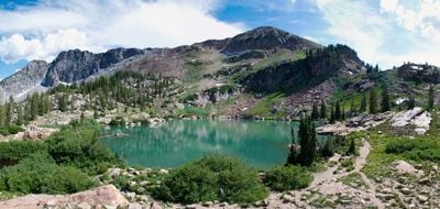
Cecret Lake, reservoir in Alta, Utah, United States

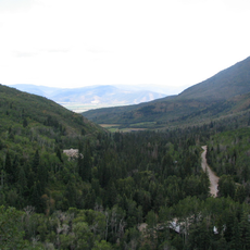
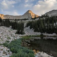
Cecret Lake is a small reservoir nestled high in Utah's mountains near Alta, surrounded by clear cold water and rocky terrain. The lake sits at the base of Sugarloaf Peak and Devils Castle, with wildflowers dotting the shoreline during summer months.

The lake was likely named by a miner who worked in the area, and the United States Geological Survey kept the unusual spelling on official maps. It has served as a critical water source for Salt Lake City since its identification as part of the Wasatch National Forest watershed.

The name 'Cecret' is pronounced like 'secret' and likely comes from a miner who worked in the area, though the reason for this unusual spelling remains a mystery. The lake has become a favorite spot for hikers and outdoor enthusiasts who come to enjoy the clear waters and mountain solitude.

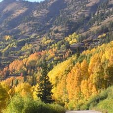
The best time to visit is from June to October when the mountain road is open and wildflowers are in bloom. Park at the Albion Basin trailhead or take a shuttle bus from Alta, especially on weekends, to avoid crowded parking situations.

Swimming is not permitted because this is a protected watershed that supplies drinking water to Salt Lake City. Seasonal snowmelt from winter through spring and summer provides a steady water source for the city.

The community of curious travelers

AroundUs brings together thousands of curated places, local tips, and hidden gems, enriched daily by 60,000 contributors worldwide.

Start exploring
Location
Elevation above the sea
3,010 m
GPS coordinates
40.57000,-111.62200
Latest update
February 7, 2026 11:00
Around this place
Little Cottonwood Canyon
United States of America

Little Cottonwood Canyon

7.2 km
Big Cottonwood Canyon
United States of America

Big Cottonwood Canyon

9.7 km
Pfeifferhorn
United States of America

Pfeifferhorn

8.2 km
Lone Peak
United States of America

Lone Peak

12.3 km
Stein Eriksen Lodge Botanical Garden
United States of America

Stein Eriksen Lodge Botanical Garden

12.4 km
Wasatch Mountain State Park
United States of America

Wasatch Mountain State Park

10.4 km
Doughnut Falls
United States of America

Doughnut Falls

7.3 km
Lone Peak Wilderness
United States of America

Lone Peak Wilderness

6.6 km
Stairs Station Hydroelectric Power Plant Historic District
United States of America

Stairs Station Hydroelectric Power Plant Historic District

12 km
St. Mary of the Assumption Church and School
United States of America

St. Mary of the Assumption Church and School

13.3 km
Glenwood Cemetery
United States of America

Glenwood Cemetery

13.2 km
IOOF Relief Home
United States of America

IOOF Relief Home

13.3 km
Richard Barrett House
United States of America

Richard Barrett House

13.3 km
James Cassidy House
United States of America

James Cassidy House

13.3 km
House at 463 Park Avenue
United States of America

House at 463 Park Avenue

13.4 km
Joseph J. Jenkins House
United States of America

Joseph J. Jenkins House

13.3 km
House at 343 Park Avenue
United States of America

House at 343 Park Avenue

13.4 km
James Cavanaugh House
United States of America

James Cavanaugh House

13.4 km
Nicholas Rowe House
United States of America

Nicholas Rowe House

13.4 km
Alfred Lindorff House
United States of America

Alfred Lindorff House

13.2 km
Albion Basin
United States of America

Albion Basin

850 m
Tibble Fork Reservoir
United States of America

Tibble Fork Reservoir

10.2 km
Maybird Gulch
United States of America

Maybird Gulch

7.5 km
Silver Lake Flat Reservoir
United States of America

Silver Lake Flat Reservoir

8 km
Silver Lake
United States of America

Silver Lake

4.7 km
Red Pine Lake
United States of America

Red Pine Lake

6.7 km
Hidden Peak
United States of America

Hidden Peak

2.2 km
Upper Bells Canyon Reservoir
United States of America

Upper Bells Canyon Reservoir

10.7 km
Show the full map
« Cecret Lake - reservoir in Alta, Utah, United States » is provided by Around Us (aroundus.com). Images and texts are derived from Wikimedia project under a Creative Commons license. You are allowed to copy, distribute, and modify copies of this page, under the conditions set by the license, as long as this note is clearly visible.

Discover hidden gems everywhere you go!

From secret cafés to breathtaking viewpoints, skip the crowded tourist spots and find places that match your style. Our app makes it easy with voice search, smart filtering, route optimization, and insider tips from travelers worldwide. Download now for the complete mobile experience.

Around Us App Screenshot

A unique approach to discovering new places

Le Figaro

All the places worth exploring

France Info

A tailor-made excursion in just a few clicks

20 Minutes

Around Us
Travel Guide & Maps
Download

Send to your phone

QR Code
1

Open the camera app on your mobile.

2

Point at the QR code with your camera. A notification will appear.

3

Tap the notification to open the link.