Enable Location

We need your location to show you interesting places around you

Discover nearby places

Find interesting locations and hidden gems around you

Precise directions

Get accurate directions and distances to places

Your location is never shared with other users. It's only used when you tap the location button.

Sun Tunnels

Log in to your account

Start exploring — it's free

Trusted by 62,836 travelers worldwide

Continue with Google
Continue with Apple
or

We will send you a code to connect

By continuing, you accept our Terms and Conditions and our Privacy Policy

Check your inbox

We've sent a pincode in your inbox. Please enter the code below.

Sun Tunnels

Sun Tunnels, Land art installation in Box Elder County, United States

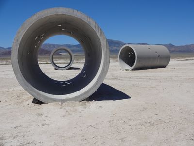
Sun Tunnels is an art installation featuring four massive concrete cylinders positioned in an X pattern across the Great Basin Desert. The tunnels stretch approximately 86 feet in length, with perforations running through them that frame views of the sky above.

Artist Nancy Holt created Sun Tunnels between 1973 and 1976 as a monumental work in Utah's remote desert. The work emerged from an artistic movement exploring how large structures could frame both time and landscape for human experience.

The concrete cylinders feature perforations arranged to match star constellations: Draco, Perseus, Columba, and Capricorn. Visitors experience a direct link between the structures and the night sky when looking through these openings.

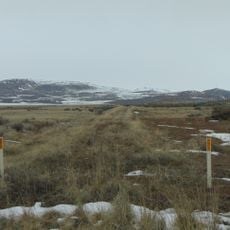
Reaching the site requires a vehicle suitable for rough dirt roads, and only high-clearance or four-wheel-drive vehicles are recommended for safe travel. Visitors should bring ample water, food, and fuel, as no services exist nearby and the drive from town takes roughly an hour each way.

During summer and winter solstices, the rising and setting sun sends light through the tunnel perforations to create temporary patterns on the ground below. These annual moments reveal how the static concrete structure interacts with the sun's seasonal movement.

The community of curious travelers

AroundUs brings together thousands of curated places, local tips, and hidden gems, enriched daily by 60,000 contributors worldwide.

Start exploring
Location
Inception
1976
Creator
Nancy Holt
Made from material
concrete
GPS coordinates
41.30349,-113.86380
Latest update
December 6, 2025 17:44
Natural monuments in Utah: archaeological sites, rock formations, thermal springs

Utah preserves thousands of years of human history alongside some of North America's most varied geological landscapes. The region contains extensive rock art panels and Ancestral Pueblo ruins, including the 13th-century stone structures at Bears Ears National Monument and the 650-plus petroglyphs...

Around this place
Spiral Jetty
United States of America

Spiral Jetty

100.9 km
Bonneville Speedway
United States of America

Bonneville Speedway

60.3 km
Metaphor: The Tree of Utah
United States of America

Metaphor: The Tree of Utah

68.7 km
City of Rocks National Reserve
United States of America

City of Rocks National Reserve

87 km
Golden Spike National Historical Park
United States of America

Golden Spike National Historical Park

115.2 km
United States of America

Japanese Village

134.3 km
Pilot Peak
United States of America

Pilot Peak

36.2 km
Danger Cave
United States of America

Danger Cave

62.7 km
Wendover Nugget
United States of America

Wendover Nugget

65 km
Jarbidge Wilderness
United States of America

Jarbidge Wilderness

131.6 km
Red Garter Casino
United States of America

Red Garter Casino

65.1 km
Deseret Peak
United States of America

Deseret Peak

140.3 km
Rainbow Casino
United States of America

Rainbow Casino

65.2 km
Castle Rocks State Park
United States of America

Castle Rocks State Park

94.1 km
Hogup Cave
United States of America

Hogup Cave

65.1 km
Cedar Mountain Wilderness
United States of America

Cedar Mountain Wilderness

110.4 km
Deseret Peak Wilderness
United States of America

Deseret Peak Wilderness

133.2 km
A. N. Tanner House
United States of America

A. N. Tanner House

44.5 km
Transcontinental Railroad Grade
United States of America

Transcontinental Railroad Grade

131.1 km
Cassia County Courthouse
United States of America

Cassia County Courthouse

137.2 km
Albion Methodist Church
United States of America

Albion Methodist Church

125.8 km
Maverick Canyon
United States of America

Maverick Canyon

67.5 km
Grantsville First Ward Meetinghouse
United States of America

Grantsville First Ward Meetinghouse

140.6 km
Marys River Peak
United States of America

Marys River Peak

134.7 km
Grantsville School and Meetinghouse
United States of America

Grantsville School and Meetinghouse

140.6 km
Chinese Arch
United States of America

Chinese Arch

119.9 km
Southern Pacific Monument
United States of America

Southern Pacific Monument

115 km
Central Pacific Railroad Grade Historic District
United States of America

Central Pacific Railroad Grade Historic District

43.6 km
Show the full map
« Sun Tunnels - Land art installation in Box Elder County, United States » is provided by Around Us (aroundus.com). Images and texts are derived from Wikimedia project under a Creative Commons license. You are allowed to copy, distribute, and modify copies of this page, under the conditions set by the license, as long as this note is clearly visible.

Discover hidden gems everywhere you go!

From secret cafés to breathtaking viewpoints, skip the crowded tourist spots and find places that match your style. Our app makes it easy with voice search, smart filtering, route optimization, and insider tips from travelers worldwide. Download now for the complete mobile experience.

Around Us App Screenshot

A unique approach to discovering new places

Le Figaro

All the places worth exploring

France Info

A tailor-made excursion in just a few clicks

20 Minutes

Around Us
Travel Guide & Maps
Download

Send to your phone

QR Code
1

Open the camera app on your mobile.

2

Point at the QR code with your camera. A notification will appear.

3

Tap the notification to open the link.