Deseret Peak Wilderness

Log in to your account

AroundUs is a community-driven map of interesting places, built by curious explorers like you. It grows with every review, story, and photo you share.
Connect to save your favorite spots, contribute locations, and create personalized routes.
By continuing, you accept our Terms and Conditions and our Privacy Policy
Add to collection
Map
Suggest a change
Share

Deseret Peak Wilderness, Protected wilderness area in Tooele County, United States.
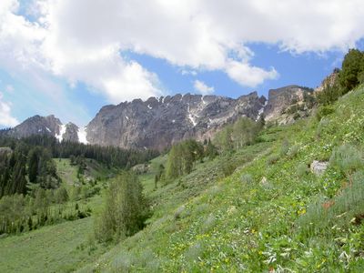
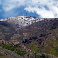
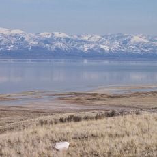
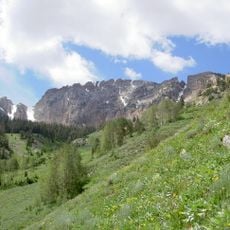
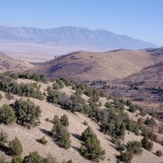
The Deseret Peak Wilderness encompasses 25,212 acres of alpine terrain with elevations reaching 11,031 feet in the Stansbury Mountains of Utah.

The wilderness area received federal protection through the Utah Wilderness Act on September 18, 1984, preserving its natural state for future generations.

The name Deseret reflects Mormon heritage, derived from the Book of Mormon word for honeybee, representing productivity and community values.

South Willow Canyon provides the main access point to five system trails totaling 19 miles through varying elevations and terrain types.

The area functions as a biological transition zone between the Great Basin and Rocky Mountains, supporting diverse plant communities from juniper to alpine fir.

Location: Tooele County

Inception: September 18, 1984

Elevation above the sea: 2,984 m

GPS coordinates: 40.46670,-112.73300

Latest update: March 11, 2025 21:39

Around this place
Show the full map
Bingham Canyon Mine
United States of America

Bingham Canyon Mine

49.8 km
Japanese Village
United States of America

Japanese Village

50.7 km
Kennecott Smokestack
United States of America

Kennecott Smokestack

53.4 km
Farnsworth Peak
United States of America

Farnsworth Peak

49.8 km
Great Salt Lake State Park
United States of America

Great Salt Lake State Park

53.3 km
Deseret Peak
United States of America

Deseret Peak

9.1 km
Black Rock
United States of America

Black Rock

51.5 km
Cedar Mountain Wilderness
United States of America

Cedar Mountain Wilderness

23 km
Bingham Canyon Reclamation Project
United States of America

Bingham Canyon Reclamation Project

49.6 km
Benson Grist Mill
United States of America

Benson Grist Mill

42.1 km
Lincoln Highway Bridge
United States of America

Lincoln Highway Bridge

35.5 km
Thomas N. Taylor House
United States of America

Thomas N. Taylor House

33.1 km
Hilda Erickson House
United States of America

Hilda Erickson House

26.7 km
Tooele County Courthouse and City Hall
United States of America

Tooele County Courthouse and City Hall

37.6 km
Alex and Mary Alice Johnson House
United States of America

Alex and Mary Alice Johnson House

27.2 km
James and Penninah Wrathall House
United States of America

James and Penninah Wrathall House

26.8 km
Grantsville First Ward Meetinghouse
United States of America

Grantsville First Ward Meetinghouse

26.7 km
Grantsville School and Meetinghouse
United States of America

Grantsville School and Meetinghouse

26.7 km
John T. Rich House
United States of America

John T. Rich House

26.7 km
Tooele Carnegie Library
United States of America

Tooele Carnegie Library

37.6 km
John C. Sharp House
United States of America

John C. Sharp House

49.2 km
Ophir Town Hall
United States of America

Ophir Town Hall

42.1 km
Johnson Hall-Deseret Mercantile Building
United States of America

Johnson Hall-Deseret Mercantile Building

27.2 km
David E. Davis House
United States of America

David E. Davis House

29 km
Reddick Hotel-Ophir LDS Meetinghouse
United States of America

Reddick Hotel-Ophir LDS Meetinghouse

41.9 km
Peter Clegg House
United States of America

Peter Clegg House

37.7 km
Stockton School
United States of America

Stockton School

31.6 km
Copperton Community Methodist Church
United States of America

Copperton Community Methodist Church

54.9 km
Show the full map

Reviews

Visited this place? Tap the stars to rate it and share your experience / photos with the community! Try now! You can cancel it anytime.

« Deseret Peak Wilderness - Protected wilderness area in Tooele County, United States. » is provided by Around Us (aroundus.com). Images and texts are derived from Wikimedia project under a Creative Commons license. You are allowed to copy, distribute, and modify copies of this page, under the conditions set by the license, as long as this note is clearly visible.

Discover hidden gems everywhere you go!

From secret cafés to breathtaking viewpoints, skip the crowded tourist spots and find places that match your style. Our app makes it easy with voice search, smart filtering, route optimization, and insider tips from travelers worldwide. Download now for the complete mobile experience.

Around Us App Screenshot

A unique approach to discovering new places

Le Figaro

All the places worth exploring

France Info

A tailor-made excursion in just a few clicks

20 Minutes