Enable Location

We need your location to show you interesting places around you

Discover nearby places

Find interesting locations and hidden gems around you

Precise directions

Get accurate directions and distances to places

Your location is never shared with other users. It's only used when you tap the location button.

Fantasy Canyon

Log in to your account

Start exploring — it's free

Trusted by 62,835 travelers worldwide

Continue with Google
Continue with Apple
or

We will send you a code to connect

By continuing, you accept our Terms and Conditions and our Privacy Policy

Check your inbox

We've sent a pincode in your inbox. Please enter the code below.

Fantasy Canyon

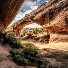
Fantasy Canyon, Sandstone canyon in Uintah County, United States.

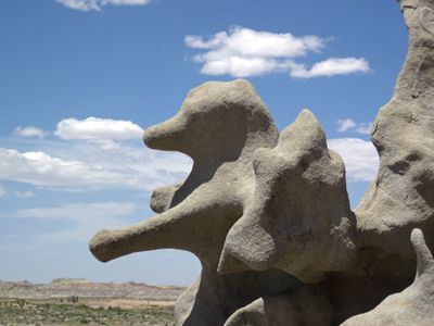
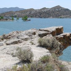
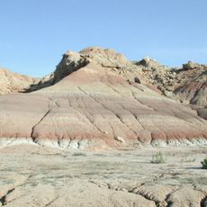
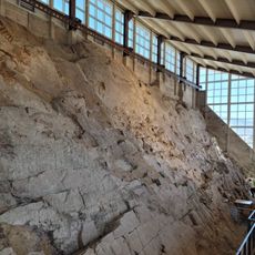
Fantasy Canyon is a sandstone canyon in Uintah County shaped by wind and water over countless years into unusual rock formations. The eroded structures display varied colors and textures that create an otherworldly landscape within a small area.

Earl Douglass, a prominent geologist, first documented this location in 1909 and called it "The Devil's Playground" and "Hades Pit" in scientific journals. His observations brought attention to the site's unusual geological formations and helped establish it as a destination.

The rock formations within the canyon received names based on their shapes, creating a natural outdoor gallery of mineral sculptures for visitors.

A loop trail winds through the canyon allowing visitors to walk among the rock formations and observe them from multiple angles. The path is short and manageable for most people, though sturdy footwear is recommended due to uneven and rocky ground.

Black bands of magnetite run through the sandstone structures along the trail and create detectable magnetic properties. This unusual geological feature allows visitors to witness how certain minerals can affect metal objects.

The community of curious travelers

AroundUs brings together thousands of curated places, local tips, and hidden gems, enriched daily by 60,000 contributors worldwide.

Start exploring
Location
Elevation above the sea
1,475 m
GPS coordinates
40.05560,-109.39500
Latest update
December 6, 2025 17:40
Natural monuments in Utah: archaeological sites, rock formations, thermal springs

Utah preserves thousands of years of human history alongside some of North America's most varied geological landscapes. The region contains extensive rock art panels and Ancestral Pueblo ruins, including the 13th-century stone structures at Bears Ears National Monument and the 650-plus petroglyphs...

Around this place
Skinwalker Ranch
United States of America

Skinwalker Ranch

47.7 km
Morrison Formation
United States of America

Morrison Formation

43.7 km
Desolation Canyon
United States of America

Desolation Canyon

88.5 km
Red Fleet State Park
United States of America

Red Fleet State Park

58.7 km
Lone Rock
United States of America

Lone Rock

81.5 km
Josie Bassett Morris Ranch Complex
United States of America

Josie Bassett Morris Ranch Complex

45.2 km
Steinaker State Park
United States of America

Steinaker State Park

52.7 km
Quarry Visitor Center
United States of America

Quarry Visitor Center

43.6 km
Ouray National Wildlife Refuge
United States of America

Ouray National Wildlife Refuge

21.1 km
Utah Field House of Natural History State Park Museum
United States of America

Utah Field House of Natural History State Park Museum

45.7 km
Dinah the Pink Dinosaur
United States of America

Dinah the Pink Dinosaur

45.7 km
Quarry Exhibit Hall
United States of America

Quarry Exhibit Hall

43.6 km
Rial Chew Ranch Complex
United States of America

Rial Chew Ranch Complex

59 km
Big Sand Wash Reservoir
United States of America

Big Sand Wash Reservoir

75.7 km
Utah Field House of Natural History State Park Museum
United States of America

Utah Field House of Natural History State Park Museum

45.7 km
Upper Wade and Curtis Cabin
United States of America

Upper Wade and Curtis Cabin

86.8 km
Earl Douglass Workshop-Laboratory
United States of America

Earl Douglass Workshop-Laboratory

43.6 km
Lewis Curry House
United States of America

Lewis Curry House

44.7 km
Manfred and Ethel Martin House
United States of America

Manfred and Ethel Martin House

46.2 km
St. Paul's Episcopal Church and Lodge
United States of America

St. Paul's Episcopal Church and Lodge

46.1 km
Gibson-Sowards House
United States of America

Gibson-Sowards House

51 km
Vernal Tithing Office
United States of America

Vernal Tithing Office

45.9 km
Moonshine Arch
United States of America

Moonshine Arch

57.1 km
Argyle Canyon
United States of America

Argyle Canyon

86.7 km
Hole in the Wall Canyon
United States of America

Hole in the Wall Canyon

62.2 km
Kenney Reservoir
United States of America

Kenney Reservoir

58.7 km
Cooper Canyon
United States of America

Cooper Canyon

40.6 km
Fenn-Bullock House
United States of America

Fenn-Bullock House

46.3 km
Show the full map
« Fantasy Canyon - Sandstone canyon in Uintah County, United States » is provided by Around Us (aroundus.com). Images and texts are derived from Wikimedia project under a Creative Commons license. You are allowed to copy, distribute, and modify copies of this page, under the conditions set by the license, as long as this note is clearly visible.

Discover hidden gems everywhere you go!

From secret cafés to breathtaking viewpoints, skip the crowded tourist spots and find places that match your style. Our app makes it easy with voice search, smart filtering, route optimization, and insider tips from travelers worldwide. Download now for the complete mobile experience.

Around Us App Screenshot

A unique approach to discovering new places

Le Figaro

All the places worth exploring

France Info

A tailor-made excursion in just a few clicks

20 Minutes

Around Us
Travel Guide & Maps
Download

Send to your phone

QR Code
1

Open the camera app on your mobile.

2

Point at the QR code with your camera. A notification will appear.

3

Tap the notification to open the link.