Enable Location

We need your location to show you interesting places around you

Discover nearby places

Find interesting locations and hidden gems around you

Precise directions

Get accurate directions and distances to places

Your location is never shared with other users. It's only used when you tap the location button.

Lone Rock

Log in to your account

Join the adventure

Create your free account and start exploring (like 60k+ others)

We will send you a code to connect

or
Continue with Google
Continue with Apple
By continuing, you accept our Terms and Conditions and our Privacy Policy

Check your inbox

We've sent a pincode in your inbox. Please enter the code below.

Lone Rock

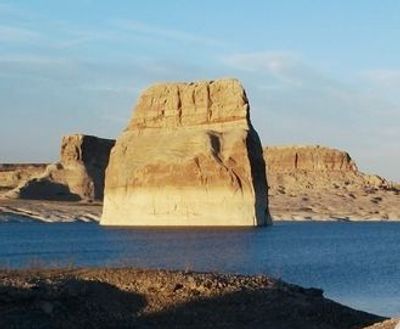
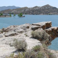
Lone Rock, Rock formation in Wahweap Bay, Lake Powell, US

Description

Lone Rock is a sandstone tower rising from the waters of Lake Powell within Glen Canyon National Recreation Area. The formation stands roughly 350 feet (107 meters) tall and displays distinctive rust-colored layers visible from the shore.

History

The sandstone formation was sculpted long before the valley was flooded, but became a visible landmark when Lake Powell filled in the 1960s. It has remained a reference point in the landscape since that transformation.

Culture

Lone Rock Beach draws people seeking water sports and shoreline camping experiences. The site has become a popular gathering place for those wanting to connect with both the lake and the rock formation.

Practical

Access comes via Route 89, with Lone Rock Beach Campground providing direct water access and camping options along the shore. A boat is necessary to reach the formation itself and explore its base.

Did you know?

The formation appeared in the 2011 Doctor Who episode The Impossible Astronaut. This television appearance introduced the site to many viewers far beyond the region.

Location
Elevation above the sea
1,129 m
GPS coordinates
40.67258,-109.91321
Latest update
December 11, 2025 11:09

AroundUs brings together thousands of curated places, local tips, and hidden gems, enriched daily by 60,000 contributors worldwide. Discover all places nearby (Kane County).

Around this place
Skinwalker Ranch
United States of America

Skinwalker Ranch

46.2 km
Morrison Formation
United States of America

Morrison Formation

57.8 km
King's Peak
United States of America

King's Peak

40.5 km
High Uintas Wilderness
United States of America

High Uintas Wilderness

49.8 km
Flaming Gorge Dam
United States of America

Flaming Gorge Dam

49.5 km
Flaming Gorge National Recreation Area
United States of America

Flaming Gorge National Recreation Area

49.5 km
Red Fleet State Park
United States of America

Red Fleet State Park

41.9 km
Steinaker State Park
United States of America

Steinaker State Park

36.7 km
Quarry Visitor Center
United States of America

Quarry Visitor Center

57.8 km
Utah Field House of Natural History State Park Museum
United States of America

Utah Field House of Natural History State Park Museum

41.2 km
Dinah the Pink Dinosaur
United States of America

Dinah the Pink Dinosaur

41.7 km
Quarry Exhibit Hall
United States of America

Quarry Exhibit Hall

57.8 km
Big Sand Wash Reservoir
United States of America

Big Sand Wash Reservoir

49.4 km
Utah Field House of Natural History State Park Museum
United States of America

Utah Field House of Natural History State Park Museum

41.1 km
Ute Mountain Fire Tower
United States of America

Ute Mountain Fire Tower

24.4 km
United States of America

South Kings Peak

40.6 km
Mount Emmons
United States of America

Mount Emmons

33.2 km
Swett Ranch
United States of America

Swett Ranch

42.6 km
Earl Douglass Workshop-Laboratory
United States of America

Earl Douglass Workshop-Laboratory

57.9 km
Lewis Curry House
United States of America

Lewis Curry House

41.4 km
Mount Powell
United States of America

Mount Powell

45.5 km
Manfred and Ethel Martin House
United States of America

Manfred and Ethel Martin House

40.4 km
St. Paul's Episcopal Church and Lodge
United States of America

St. Paul's Episcopal Church and Lodge

40.2 km
Gibson-Sowards House
United States of America

Gibson-Sowards House

37.4 km
Vernal Tithing Office
United States of America

Vernal Tithing Office

40.1 km
Moonshine Arch
United States of America

Moonshine Arch

33.6 km
Hole in the Wall Canyon
United States of America

Hole in the Wall Canyon

37 km
Fenn-Bullock House
United States of America

Fenn-Bullock House

40 km
Show the full map
« Lone Rock - Rock formation in Wahweap Bay, Lake Powell, US » is provided by Around Us (aroundus.com). Images and texts are derived from Wikimedia project under a Creative Commons license. You are allowed to copy, distribute, and modify copies of this page, under the conditions set by the license, as long as this note is clearly visible.

Discover hidden gems everywhere you go!

From secret cafés to breathtaking viewpoints, skip the crowded tourist spots and find places that match your style. Our app makes it easy with voice search, smart filtering, route optimization, and insider tips from travelers worldwide. Download now for the complete mobile experience.

Around Us App Screenshot

A unique approach to discovering new places

Le Figaro

All the places worth exploring

France Info

A tailor-made excursion in just a few clicks

20 Minutes

Around Us
Travel Guide & Maps
Download

Send to your phone

QR Code
1

Open the camera app on your mobile.

2

Point at the QR code with your camera. A notification will appear.

3

Tap the notification to open the link.