Flaming Gorge Dam

Log in to your account

AroundUs is a community-driven map of interesting places, built by curious explorers like you. It grows with every review, story, and photo you share.
Connect to save your favorite spots, contribute locations, and create personalized routes.
Continue with Google
Continue with Apple
Continue with X
Continue with Facebook
Continue with email
By continuing, you accept our Terms and Conditions and our Privacy Policy
Create an account
Add to collection
Map
Suggest a change
Share

Flaming Gorge Dam, Hydroelectric power station in Daggett County, Utah.

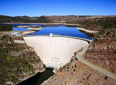
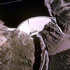
Flaming Gorge Dam is a concrete arch structure that rises 502 feet (153 meters) above the Green River bed and stretches 1,285 feet (392 meters) across the canyon in northern Utah. The powerhouse contains three turbines that generate electricity from water released through penstocks, while the structure also regulates downstream flow for irrigation and municipal use.

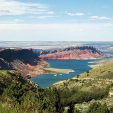
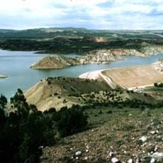
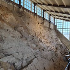
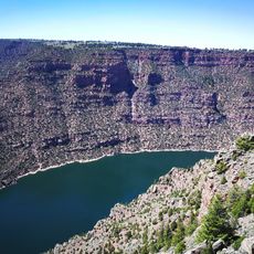
Construction began in 1958 as part of the Colorado River Storage Project and finished in 1964 to provide hydroelectric power and regulate water for irrigation downstream. Flooding the canyon created Flaming Gorge Reservoir, which extends 91 miles (146 kilometers) northward into Wyoming.

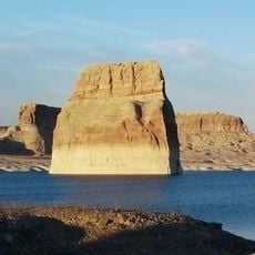
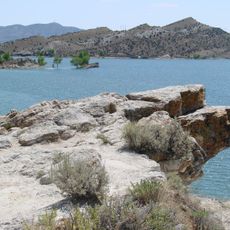
The reservoir behind the structure serves as a weekend destination for families from Wyoming and Utah who come to camp, fish for trout, and launch boats. Several overlooks along the shoreline provide views where visitors watch watercraft and observe the changing water levels throughout the seasons.

Guided tours of the facility explain turbine operations and water management systems throughout the year, with advance reservations recommended during summer months. A visitor center on the western shore offers maps, exhibits about the region, and access to viewpoints along the crest of the structure.

The section of the Green River below the structure holds one of the highest fish populations per mile in the country, drawing anglers from across multiple states. Cold water released from deeper layers of the reservoir creates conditions that favor trout species year-round.

Location: Daggett County

Inception: 1958

Elevation above the sea: 1,841 m

Length: 392 m

GPS coordinates: 40.91440,-109.42100

Latest update: December 5, 2025 22:30

Photos
Around this place
Morrison Formation
United States of America

Morrison Formation

53.6 km
Flaming Gorge Reservoir
United States of America

Flaming Gorge Reservoir

29.6 km
Flaming Gorge National Recreation Area
United States of America

Flaming Gorge National Recreation Area

0 m
Red Fleet State Park
United States of America

Red Fleet State Park

37 km
Lone Rock
United States of America

Lone Rock

49.5 km
Josie Bassett Morris Ranch Complex
United States of America

Josie Bassett Morris Ranch Complex

58.3 km
Steinaker State Park
United States of America

Steinaker State Park

45.1 km
Quarry Visitor Center
United States of America

Quarry Visitor Center

53.7 km
Expedition Island
United States of America

Expedition Island

67.9 km
Utah Field House of Natural History State Park Museum
United States of America

Utah Field House of Natural History State Park Museum

51.8 km
Dinah the Pink Dinosaur
United States of America

Dinah the Pink Dinosaur

51.6 km
Wilkins Peak
United States of America

Wilkins Peak

65 km
Quarry Exhibit Hall
United States of America

Quarry Exhibit Hall

53.7 km
Rial Chew Ranch Complex
United States of America

Rial Chew Ranch Complex

57.7 km
Utah Field House of Natural History State Park Museum
United States of America

Utah Field House of Natural History State Park Museum

51.8 km
Old Ladore School
United States of America

Old Ladore School

47 km
Upper Wade and Curtis Cabin
United States of America

Upper Wade and Curtis Cabin

50.4 km
Ute Mountain Fire Tower
United States of America

Ute Mountain Fire Tower

31.6 km
Scott's Bottom Nature Area
United States of America

Scott's Bottom Nature Area

64.8 km
Swett Ranch
United States of America

Swett Ranch

6.8 km
Earl Douglass Workshop-Laboratory
United States of America

Earl Douglass Workshop-Laboratory

53.7 km
Lewis Curry House
United States of America

Lewis Curry House

53.1 km
Manfred and Ethel Martin House
United States of America

Manfred and Ethel Martin House

51.6 km
St. Paul's Episcopal Church and Lodge
United States of America

St. Paul's Episcopal Church and Lodge

51.9 km
Gibson-Sowards House
United States of America

Gibson-Sowards House

46.9 km
Vernal Tithing Office
United States of America

Vernal Tithing Office

52.3 km
Moonshine Arch
United States of America

Moonshine Arch

41.3 km
Hole in the Wall Canyon
United States of America

Hole in the Wall Canyon

34.3 km
Show the full map
Reviews

Visited this place? Tap the stars to rate it and share your experience / photos with the community! Try now! You can cancel it anytime.

« Flaming Gorge Dam - Hydroelectric power station in Daggett County, Utah » is provided by Around Us (aroundus.com). Images and texts are derived from Wikimedia project under a Creative Commons license. You are allowed to copy, distribute, and modify copies of this page, under the conditions set by the license, as long as this note is clearly visible.

Discover hidden gems everywhere you go!

From secret cafés to breathtaking viewpoints, skip the crowded tourist spots and find places that match your style. Our app makes it easy with voice search, smart filtering, route optimization, and insider tips from travelers worldwide. Download now for the complete mobile experience.

Around Us App Screenshot

A unique approach to discovering new places

Le Figaro

All the places worth exploring

France Info

A tailor-made excursion in just a few clicks

20 Minutes