Enable Location

We need your location to show you interesting places around you

Discover nearby places

Find interesting locations and hidden gems around you

Precise directions

Get accurate directions and distances to places

Your location is never shared with other users. It's only used when you tap the location button.

Old Ladore School

Log in to your account

Start exploring — it's free

Trusted by 62,832 travelers worldwide

Continue with Google
Continue with Apple
or

We will send you a code to connect

By continuing, you accept our Terms and Conditions and our Privacy Policy

Check your inbox

We've sent a pincode in your inbox. Please enter the code below.

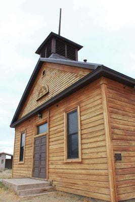
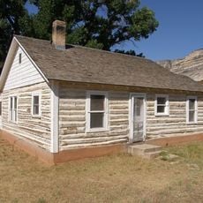
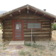
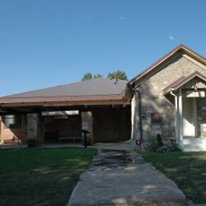
Old Ladore School, school building in Moffat County, Colorado

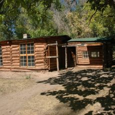
Old Ladore School is a school building in Moffat County, Colorado, built in 1911 and listed on the National Register of Historic Places. It features simple rectangular construction with large windows for classroom light, wooden floors, and basic furnishings typical of early 1900s rural schools.

The building was constructed in 1911 when rural schools in Colorado were expanding to serve scattered communities. It is part of the Rural School Buildings in Colorado Multiple Property Submission, a collection that documents how education grew in remote areas during the early 20th century.

The school served as a gathering place for the rural community beyond just teaching, hosting meetings and social events that strengthened local bonds. Its simple design and remote location reflect how education in early Colorado was distributed across small settlements rather than concentrated in towns.

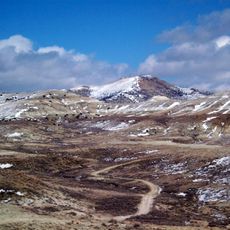
The building is located near Green River on State Route 318 in a rural setting that allows for quiet exploration. Visitors should be prepared for uneven terrain and the remote location typical of early rural Colorado schools.

The school was designed by architects Hunt, Evers, and Hoover, whose work shaped rural schools across the state despite remaining largely unknown. Their simple approach proved that functional education spaces did not require expensive materials or elaborate decoration to serve their communities effectively.

The community of curious travelers

AroundUs brings together thousands of curated places, local tips, and hidden gems, enriched daily by 60,000 contributors worldwide.

Start exploring
Location
Inception
1911
GPS coordinates
40.78000,-108.89222
Latest update
February 9, 2026 07:40
Around this place
Morrison Formation
United States of America

Morrison Formation

51.1 km
Flaming Gorge Reservoir
United States of America

Flaming Gorge Reservoir

69.8 km
Flaming Gorge Dam
United States of America

Flaming Gorge Dam

47 km
Flaming Gorge National Recreation Area
United States of America

Flaming Gorge National Recreation Area

47 km
Red Fleet State Park
United States of America

Red Fleet State Park

50.6 km
Lone Rock
United States of America

Lone Rock

87 km
Josie Bassett Morris Ranch Complex
United States of America

Josie Bassett Morris Ranch Complex

46.1 km
Steinaker State Park
United States of America

Steinaker State Park

61.3 km
Quarry Visitor Center
United States of America

Quarry Visitor Center

51.2 km
Utah Field House of Natural History State Park Museum
United States of America

Utah Field House of Natural History State Park Museum

64.1 km
Dinah the Pink Dinosaur
United States of America

Dinah the Pink Dinosaur

63.5 km
Wilkins Peak
United States of America

Wilkins Peak

88.3 km
Quarry Exhibit Hall
United States of America

Quarry Exhibit Hall

51.2 km
Rial Chew Ranch Complex
United States of America

Rial Chew Ranch Complex

32.9 km
Utah Field House of Natural History State Park Museum
United States of America

Utah Field House of Natural History State Park Museum

64.2 km
Upper Wade and Curtis Cabin
United States of America

Upper Wade and Curtis Cabin

6 km
Ute Mountain Fire Tower
United States of America

Ute Mountain Fire Tower

76.5 km
Swett Ranch
United States of America

Swett Ranch

51.3 km
Earl Douglass Workshop-Laboratory
United States of America

Earl Douglass Workshop-Laboratory

51.2 km
Lewis Curry House
United States of America

Lewis Curry House

65.4 km
Manfred and Ethel Martin House
United States of America

Manfred and Ethel Martin House

64.6 km
St. Paul's Episcopal Church and Lodge
United States of America

St. Paul's Episcopal Church and Lodge

65 km
Gibson-Sowards House
United States of America

Gibson-Sowards House

62.4 km
Vernal Tithing Office
United States of America

Vernal Tithing Office

65.6 km
Moonshine Arch
United States of America

Moonshine Arch

60.6 km
Hole in the Wall Canyon
United States of America

Hole in the Wall Canyon

53.3 km
Kenney Reservoir
United States of America

Kenney Reservoir

75.4 km
Fenn-Bullock House
United States of America

Fenn-Bullock House

65.1 km
Show the full map
« Old Ladore School - school building in Moffat County, Colorado » is provided by Around Us (aroundus.com). Images and texts are derived from Wikimedia project under a Creative Commons license. You are allowed to copy, distribute, and modify copies of this page, under the conditions set by the license, as long as this note is clearly visible.

Discover hidden gems everywhere you go!

From secret cafés to breathtaking viewpoints, skip the crowded tourist spots and find places that match your style. Our app makes it easy with voice search, smart filtering, route optimization, and insider tips from travelers worldwide. Download now for the complete mobile experience.

Around Us App Screenshot

A unique approach to discovering new places

Le Figaro

All the places worth exploring

France Info

A tailor-made excursion in just a few clicks

20 Minutes

Around Us
Travel Guide & Maps
Download

Send to your phone

QR Code
1

Open the camera app on your mobile.

2

Point at the QR code with your camera. A notification will appear.

3

Tap the notification to open the link.