Chest opened
+${chestReward.xp} XP
Explorer
NOUVEAU ×${chestReward.collectible.quantity}
tapez pour fermer
Chest locked

Open chests in the app

Around Us is built for your phone — chests unlock when you walk, explore and capture nearby places.

Enable Location

We need your location to show you interesting places around you

Discover nearby places

Find interesting locations and hidden gems around you

Precise directions

Get accurate directions and distances to places

Your location is never shared with other users. It's only used when you tap the location button.

Log in to your account

Start exploring — it's free

Trusted by 73,059 travelers worldwide

Continue with Google
Continue with Apple
or

We will send you a code to connect

By continuing, you accept our Terms and Conditions and our Privacy Policy

Check your inbox

We've sent a pincode in your inbox. Please enter the code below.

Taos Plateau volcanic field
Discussion Reviews Photo
3.3k Popularity

Taos Plateau volcanic field, Volcanic field in northern New Mexico, United States.

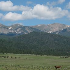
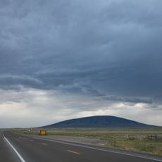
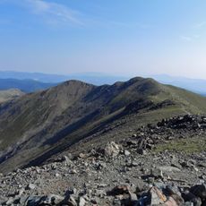
The Taos Plateau volcanic field is a large zone of cinder cones, lava flows, and dark basalt surfaces spread across northern New Mexico. The terrain shows several phases of volcanic activity, all of which remain visible across the open landscape.

Volcanic activity in this region started roughly 22 million years ago, making it one of the oldest known phases of the Rio Grande Rift. The most recent lava flows seen across the surface formed between about 1.8 and 4 million years ago.

The Pueblo peoples of the region have long seen this landscape as part of their connection to the land, not just as rock and soil. The dark basalt surfaces and the fertile ground they helped create still shape how local communities relate to the place they live in.

The dark basalt surfaces are easy to see from Highway 285 near San Antonio, where the road runs close to the lava flows. Anyone planning to walk across the terrain should wear sturdy shoes, as the ground is rocky and uneven throughout.

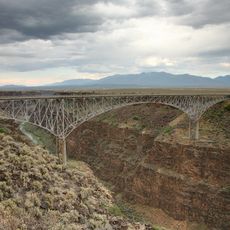
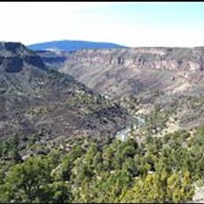
The Rio Grande Gorge cuts right through this volcanic field, exposing layers of basalt along its walls that act like a natural cross-section of millions of years of geology. Visitors standing at the rim can read the different eruption phases directly in the rock face below them.

The community of curious travelers

AroundUs brings together thousands of curated places, local tips, and hidden gems, enriched daily by 60,000 contributors worldwide.

Start exploring
Location
GPS coordinates
36.83000,-105.83000
Latest update
March 3, 2026 13:58
Around this place
Wheeler Peak
United States of America

Wheeler Peak

47.8 km
Rio Grande Gorge Bridge
United States of America

Rio Grande Gorge Bridge

40.3 km
D. H. Lawrence Ranch
United States of America

D. H. Lawrence Ranch

34.8 km
Rio Grande del Norte National Monument
United States of America

Rio Grande del Norte National Monument

23.3 km
Taos Downtown Historic District
United States of America

Taos Downtown Historic District

52.4 km
San Antonio Mountain
United States of America

San Antonio Mountain

17.2 km
Martinez Hacienda
United States of America

Martinez Hacienda

51.8 km
Harwood Museum of Art
United States of America

Harwood Museum of Art

52.4 km
John Dunn Bridge
United States of America

John Dunn Bridge

34.6 km
Latir Peak Wilderness
United States of America

Latir Peak Wilderness

31.3 km
Wild Rivers Recreation Area
United States of America

Wild Rivers Recreation Area

21.8 km
Taos Inn
United States of America

Taos Inn

52.3 km
Nicolai Fechin House
United States of America

Nicolai Fechin House

52.2 km
Wheeler Peak Wilderness
United States of America

Wheeler Peak Wilderness

45.4 km
Pike's Stockade
United States of America

Pike's Stockade

51.6 km
Taos Art Museum
United States of America

Taos Art Museum

52.2 km
Governor Charles Bent House
United States of America

Governor Charles Bent House

52.2 km
Ernest L. Blumenschein House
United States of America

Ernest L. Blumenschein House

52.4 km
Mount Walter
United States of America

Mount Walter

47.7 km
Taos Pueblo
United States of America

Taos Pueblo

50.4 km
La Loma Plaza Historic District
United States of America

La Loma Plaza Historic District

52.1 km
United States of America

San Luis Hills

38.3 km
Palace Hotel
United States of America

Palace Hotel

31.7 km
Carson School
United States of America

Carson School

52.1 km
Bernard J. Beimer House
United States of America

Bernard J. Beimer House

51.5 km
Hernández-Manby House
United States of America

Hernández-Manby House

52.3 km
Hacienda de Los Martinez Museum
United States of America

Hacienda de Los Martinez Museum

51.7 km
Veterans Memorial
United States of America

Veterans Memorial

52.3 km
Show the full map
Reviews
Share your experience

No review yet

Discussions
Start a discussion...

No discussion yet

« Taos Plateau volcanic field - Volcanic field in northern New Mexico, United States » is provided by Around Us (aroundus.com). Images and texts are derived from Wikimedia project under a Creative Commons license. You are allowed to copy, distribute, and modify copies of this page, under the conditions set by the license, as long as this note is clearly visible.

Discover hidden gems everywhere you go!

From secret cafés to breathtaking viewpoints, skip the crowded tourist spots and find places that match your style. Our app makes it easy with voice search, smart filtering, route optimization, and insider tips from travelers worldwide. Download now for the complete mobile experience.

Around Us App Screenshot

A unique approach to discovering new places

Le Figaro

All the places worth exploring

France Info

A tailor-made excursion in just a few clicks

20 Minutes

Around Us
Travel Guide & Maps
Download

Send to your phone

QR Code
1

Open the camera app on your mobile.

2

Point at the QR code with your camera. A notification will appear.

3

Tap the notification to open the link.