Enable Location

We need your location to show you interesting places around you

Discover nearby places

Find interesting locations and hidden gems around you

Precise directions

Get accurate directions and distances to places

Your location is never shared with other users. It's only used when you tap the location button.

Mount Walter

Log in to your account

Start exploring — it's free

Trusted by 62,056 travelers worldwide

Continue with Google
Continue with Apple
or

We will send you a code to connect

By continuing, you accept our Terms and Conditions and our Privacy Policy

Check your inbox

We've sent a pincode in your inbox. Please enter the code below.

Mount Walter

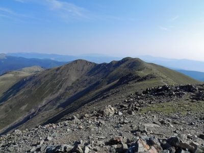
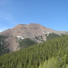
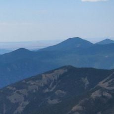
Mount Walter, Mountain summit in Taos Mountains, New Mexico, US.

Mount Walter is a summit in the Sangre de Cristo mountain range, part of the larger Rocky Mountains system. The peak stands above 4,000 meters and sits within the Carson National Forest in northern New Mexico.

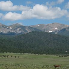
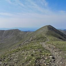
The surrounding area became a protected wilderness in 1964 when Congress designated the Wheeler Peak Wilderness. This protection preserved the landscape and restricted development in the high mountain region.

The mountain serves as a natural gathering point for hikers and outdoor enthusiasts who come to experience the high alpine environment. The peak connects visitors to the outdoor traditions that define mountain culture in northern New Mexico.

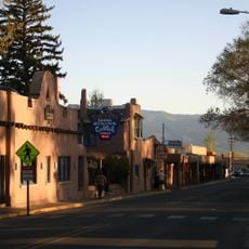
Hikers can access the mountain from trailheads near Taos, with the main routes departing from the Taos Ski Valley area. The terrain is steep and conditions change with altitude, so preparation is essential for any ascent.

The peak rises just slightly above a nearby unnamed point, yet holds the distinction of being New Mexico's second-highest named summit. This small difference in elevation is enough to give the mountain its independent status among the state's highest peaks.

The community of curious travelers

AroundUs brings together thousands of curated places, local tips, and hidden gems, enriched daily by 60,000 contributors worldwide.

Start exploring
Location
GPS coordinates
36.56102,-105.41450
Latest update
December 14, 2025 11:01
Around this place
Wheeler Peak
United States of America

Wheeler Peak

504 m
Baldy Mountain
United States of America

Baldy Mountain

19.6 km
D. H. Lawrence Ranch
United States of America

D. H. Lawrence Ranch

16.2 km
Cimarron Canyon State Park
United States of America

Cimarron Canyon State Park

21.6 km
Eagle Nest Lake State Park
United States of America

Eagle Nest Lake State Park

15 km
Mabel Dodge Luhan House
United States of America

Mabel Dodge Luhan House

21.7 km
Taos Downtown Historic District
United States of America

Taos Downtown Historic District

22.2 km
Kit Carson House
United States of America

Kit Carson House

22.2 km
Mount Phillips
United States of America

Mount Phillips

24.7 km
Harwood Museum of Art
United States of America

Harwood Museum of Art

22.6 km
Eagle Nest Dam
United States of America

Eagle Nest Dam

16.9 km
Taos Inn
United States of America

Taos Inn

22.1 km
Nicolai Fechin House
United States of America

Nicolai Fechin House

21.8 km
Wheeler Peak Wilderness
United States of America

Wheeler Peak Wilderness

2.7 km
La Morada de Nuestra Senora de Guadalupe
United States of America

La Morada de Nuestra Senora de Guadalupe

21.7 km
Vietnam Veterans Memorial State Park
United States of America

Vietnam Veterans Memorial State Park

17.2 km
Taos Art Museum
United States of America

Taos Art Museum

21.8 km
Governor Charles Bent House
United States of America

Governor Charles Bent House

22.1 km
Ernest L. Blumenschein House
United States of America

Ernest L. Blumenschein House

22.6 km
Eanger Irving Couse House and Studio—Joseph Henry Sharp Studios
United States of America

Eanger Irving Couse House and Studio—Joseph Henry Sharp Studios

22.3 km
Taos Pueblo
United States of America

Taos Pueblo

18.1 km
La Loma Plaza Historic District
United States of America

La Loma Plaza Historic District

22.8 km
Leon Gaspard House
United States of America

Leon Gaspard House

22.8 km
E. Martin Hennings House and Studio Historic District
United States of America

E. Martin Hennings House and Studio Historic District

22.6 km
Bernard J. Beimer House
United States of America

Bernard J. Beimer House

21.4 km
Hernández-Manby House
United States of America

Hernández-Manby House

22.1 km
Veterans Memorial
United States of America

Veterans Memorial

22.3 km
Old Taos County Courthouse
United States of America

Old Taos County Courthouse

22.3 km
Show the full map
« Mount Walter - Mountain summit in Taos Mountains, New Mexico, US » is provided by Around Us (aroundus.com). Images and texts are derived from Wikimedia project under a Creative Commons license. You are allowed to copy, distribute, and modify copies of this page, under the conditions set by the license, as long as this note is clearly visible.

Discover hidden gems everywhere you go!

From secret cafés to breathtaking viewpoints, skip the crowded tourist spots and find places that match your style. Our app makes it easy with voice search, smart filtering, route optimization, and insider tips from travelers worldwide. Download now for the complete mobile experience.

Around Us App Screenshot

A unique approach to discovering new places

Le Figaro

All the places worth exploring

France Info

A tailor-made excursion in just a few clicks

20 Minutes

Around Us
Travel Guide & Maps
Download

Send to your phone

QR Code
1

Open the camera app on your mobile.

2

Point at the QR code with your camera. A notification will appear.

3

Tap the notification to open the link.