Enable Location

We need your location to show you interesting places around you

Discover nearby places

Find interesting locations and hidden gems around you

Precise directions

Get accurate directions and distances to places

Your location is never shared with other users. It's only used when you tap the location button.

Mount Phillips

Log in to your account

Join the adventure

Create your free account and start exploring (like 60k+ others)

We will send you a code to connect

or
Continue with Google
Continue with Apple
By continuing, you accept our Terms and Conditions and our Privacy Policy

Check your inbox

We've sent a pincode in your inbox. Please enter the code below.

Mount Phillips

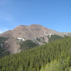
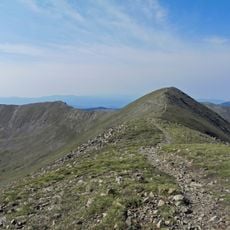
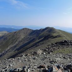
Mount Phillips, Mountain summit in Sangre de Cristo Mountains, New Mexico, US.

Description

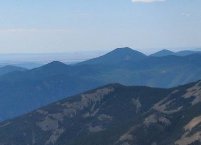
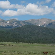
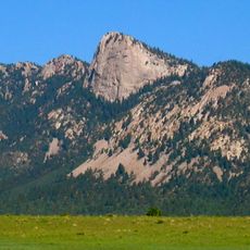
Mount Phillips is a summit in the Sangre de Cristo Mountains of northern New Mexico, rising to about 11,700 feet above sea level. The peak overlooks miles of wilderness and sits within a mountain range that forms part of the larger Rocky Mountain system.

History

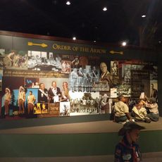
The mountain was originally called Clear Creek Mountain until it received its current name in 1960 to honor a major land donor to scouting organizations. This change reflected the area's growing importance as a training ground for youth groups.

Culture

The summit draws thousands of young people each year who come to test themselves in the wilderness and develop outdoor skills. This steady flow of youth visitors has made the peak a well-traveled landmark within scouting circles.

Practical

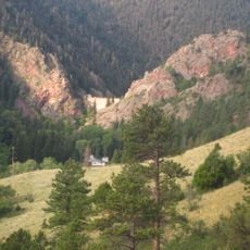
The mountain can be reached by hiking from different trailheads depending on your route, and the climb requires moderate fitness and hiking experience. Start early in the day and bring plenty of water, as weather at higher elevations can shift quickly.

Did you know?

The mountain is made of pink gneiss rock that shimmers distinctly in sunlight, visible everywhere along the hiking paths to the summit. This geological feature gives the peak a distinctive appearance that sets it apart from other mountains in the region.

Location
GPS coordinates
36.47667,-105.15950
Latest update
December 10, 2025 20:01

AroundUs brings together thousands of curated places, local tips, and hidden gems, enriched daily by 60,000 contributors worldwide. Discover all places nearby (New Mexico).

Around this place
Wheeler Peak
United States of America

Wheeler Peak

24.7 km
Baldy Mountain
United States of America

Baldy Mountain

17.7 km
St. James Hotel
United States of America

St. James Hotel

21.6 km
Tooth of Time
United States of America

Tooth of Time

13.9 km
Cimarron Canyon State Park
United States of America

Cimarron Canyon State Park

6.9 km
Eagle Nest Lake State Park
United States of America

Eagle Nest Lake State Park

10.3 km
Mabel Dodge Luhan House
United States of America

Mabel Dodge Luhan House

37.1 km
Villa Philmonte
United States of America

Villa Philmonte

19 km
Eagle Nest Dam
United States of America

Eagle Nest Dam

8.7 km
Nicolai Fechin House
United States of America

Nicolai Fechin House

37.4 km
Wheeler Peak Wilderness
United States of America

Wheeler Peak Wilderness

26.5 km
La Morada de Nuestra Senora de Guadalupe
United States of America

La Morada de Nuestra Senora de Guadalupe

37 km
Vietnam Veterans Memorial State Park
United States of America

Vietnam Veterans Memorial State Park

12.7 km
Taos Art Museum
United States of America

Taos Art Museum

37.4 km
Eanger Irving Couse House and Studio—Joseph Henry Sharp Studios
United States of America

Eanger Irving Couse House and Studio—Joseph Henry Sharp Studios

37.7 km
Mount Walter
United States of America

Mount Walter

24.7 km
Taos Pueblo
United States of America

Taos Pueblo

35 km
Ocate Peak
United States of America

Ocate Peak

36.3 km
Casa del Gavilan
United States of America

Casa del Gavilan

16.9 km
Cimarron Historic District
United States of America

Cimarron Historic District

21.5 km
Leon Gaspard House
United States of America

Leon Gaspard House

37.4 km
E. Martin Hennings House and Studio Historic District
United States of America

E. Martin Hennings House and Studio Historic District

37.6 km
Narciso Valdez House
United States of America

Narciso Valdez House

34.9 km
Bernard J. Beimer House
United States of America

Bernard J. Beimer House

37.5 km
Hernández-Manby House
United States of America

Hernández-Manby House

37.7 km
National Scouting Museum
United States of America

National Scouting Museum

18.6 km
Villa Philmonte
United States of America

Villa Philmonte

18.9 km
Kit Carson Museum
United States of America

Kit Carson Museum

23.9 km
Show the full map
« Mount Phillips - Mountain summit in Sangre de Cristo Mountains, New Mexico, US » is provided by Around Us (aroundus.com). Images and texts are derived from Wikimedia project under a Creative Commons license. You are allowed to copy, distribute, and modify copies of this page, under the conditions set by the license, as long as this note is clearly visible.

Discover hidden gems everywhere you go!

From secret cafés to breathtaking viewpoints, skip the crowded tourist spots and find places that match your style. Our app makes it easy with voice search, smart filtering, route optimization, and insider tips from travelers worldwide. Download now for the complete mobile experience.

Around Us App Screenshot

A unique approach to discovering new places

Le Figaro

All the places worth exploring

France Info

A tailor-made excursion in just a few clicks

20 Minutes

Around Us
Travel Guide & Maps
Download

Send to your phone

QR Code
1

Open the camera app on your mobile.

2

Point at the QR code with your camera. A notification will appear.

3

Tap the notification to open the link.