Ocate Peak

Log in to your account

AroundUs is a community-driven map of interesting places, built by curious explorers like you. It grows with every review, story, and photo you share.
Connect to save your favorite spots, contribute locations, and create personalized routes.
Continue with Google
Continue with Apple
Continue with X
Continue with Facebook
Continue with email
By continuing, you accept our Terms and Conditions and our Privacy Policy
Create an account
Add to collection
Map
Suggest a change
Share

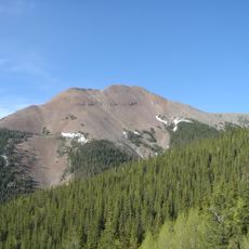
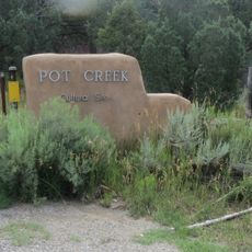
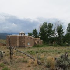
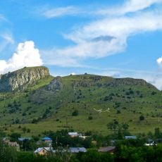
Ocate Peak, Mountain summit in Mora County, New Mexico, US.

Ocate Peak is a mountain summit in Mora County that rises to about 7,788 feet and combines exposed rock with forested slopes throughout. Native plants and conifers cover the terrain, creating varied landscapes across the mountainside.

The mountain served as a key landmark for travelers following the Santa Fe Trail during early trade routes. In the 19th century, merchants shifted to using the Cimarron Cutoff instead, reducing its importance.

The name comes from a Nahuatl word meaning pine, referencing the trees that cover much of the mountainside. These conifers shape how the place looks and feels today.

State Road 120 provides direct access to the northern section, with several hiking trails starting from the base. The approach is straightforward, though visitors should prepare for variable weather at higher elevations.

The mountain's volcanic origin creates a distinctive shape that stands out against the northeastern landscape from many directions. This recognizable profile makes it easy to spot from various vantage points across the region.

Location: New Mexico

GPS coordinates: 36.16559,-105.03806

Latest update: December 14, 2025 12:25

Photos
Around this place
Baldy Mountain
United States of America

Baldy Mountain

54 km
St. James Hotel
United States of America

St. James Hotel

39.2 km
Tooth of Time
United States of America

Tooth of Time

31.5 km
Cimarron Canyon State Park
United States of America

Cimarron Canyon State Park

43.2 km
Eagle Nest Lake State Park
United States of America

Eagle Nest Lake State Park

45.1 km
Mabel Dodge Luhan House
United States of America

Mabel Dodge Luhan House

54.5 km
Mount Phillips
United States of America

Mount Phillips

36.3 km
Villa Philmonte
United States of America

Villa Philmonte

33.6 km
Eagle Nest Dam
United States of America

Eagle Nest Dam

44.2 km
Pot Creek Cultural Site
United States of America

Pot Creek Cultural Site

49.9 km
La Morada de Nuestra Senora de Guadalupe
United States of America

La Morada de Nuestra Senora de Guadalupe

54.2 km
Vietnam Veterans Memorial State Park
United States of America

Vietnam Veterans Memorial State Park

38.3 km
Wagon Mound National Historic Landmark
United States of America

Wagon Mound National Historic Landmark

36 km
Colfax County Courthouse
United States of America

Colfax County Courthouse

45.5 km
Casa del Gavilan
United States of America

Casa del Gavilan

30.6 km
Watrous
United States of America

Watrous

40.7 km
Cimarron Historic District
United States of America

Cimarron Historic District

39.1 km
Leon Gaspard House
United States of America

Leon Gaspard House

53.8 km
Mills House
United States of America

Mills House

45.4 km
R.H. Cowan Livery Stable
United States of America

R.H. Cowan Livery Stable

45.3 km
E. Martin Hennings House and Studio Historic District
United States of America

E. Martin Hennings House and Studio Historic District

54.3 km
Narciso Valdez House
United States of America

Narciso Valdez House

1.5 km
St. Vrain's Mill
United States of America

St. Vrain's Mill

33.7 km
Daniel Cassidy and Sons General Merchandise Store
United States of America

Daniel Cassidy and Sons General Merchandise Store

35.5 km
La Cueva Historic District
United States of America

La Cueva Historic District

31.2 km
Cassidy Mill
United States of America

Cassidy Mill

35.1 km
National Scouting Museum
United States of America

National Scouting Museum

33.1 km
Villa Philmonte
United States of America

Villa Philmonte

33.6 km
Show the full map
Reviews

Visited this place? Tap the stars to rate it and share your experience / photos with the community! Try now! You can cancel it anytime.

« Ocate Peak - Mountain summit in Mora County, New Mexico, US » is provided by Around Us (aroundus.com). Images and texts are derived from Wikimedia project under a Creative Commons license. You are allowed to copy, distribute, and modify copies of this page, under the conditions set by the license, as long as this note is clearly visible.

Discover hidden gems everywhere you go!

From secret cafés to breathtaking viewpoints, skip the crowded tourist spots and find places that match your style. Our app makes it easy with voice search, smart filtering, route optimization, and insider tips from travelers worldwide. Download now for the complete mobile experience.

Around Us App Screenshot

A unique approach to discovering new places

Le Figaro

All the places worth exploring

France Info

A tailor-made excursion in just a few clicks

20 Minutes