Enable Location

We need your location to show you interesting places around you

Discover nearby places

Find interesting locations and hidden gems around you

Precise directions

Get accurate directions and distances to places

Your location is never shared with other users. It's only used when you tap the location button.

Eagle Nest Dam

Log in to your account

Start exploring — it's free

Trusted by 62,056 travelers worldwide

Continue with Google
Continue with Apple
or

We will send you a code to connect

By continuing, you accept our Terms and Conditions and our Privacy Policy

Check your inbox

We've sent a pincode in your inbox. Please enter the code below.

Eagle Nest Dam, Arch dam in Colfax County, New Mexico.

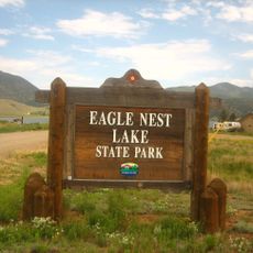
Eagle Nest Dam is an arch dam spanning the Cimarron River in Colfax County with a width of about 400 feet (122 m) and height of about 140 feet (43 m). The structure creates Eagle Nest Lake, which sits behind the dam and serves the surrounding area.

The dam was built between 1916 and 1918 by Taos Pueblo workers and resulted from an initiative by Frank and Charles Springer through their land company. The project emerged to store water for irrigation and marked an important phase in the region's water development.

The dam plays a central role in local water management and remains connected to the region's agricultural development. Visitors can observe how this structure shaped settlement patterns and economic activity throughout the valley.

The structure creates a lake that supplies irrigation water through canals to farms and ranches located downstream. The best time to visit is during summer when water levels are adequate and weather conditions are pleasant.

The dam was for many years the largest privately initiated project of its kind in the United States and set new standards in water engineering. The water distribution system relies on innovative legal procedures governing usage rights among different users.

The community of curious travelers

AroundUs brings together thousands of curated places, local tips, and hidden gems, enriched daily by 60,000 contributors worldwide.

Start exploring
Location
GPS coordinates
36.53167,-105.22889
Latest update
December 12, 2025 09:06
Around this place
Wheeler Peak
United States of America

Wheeler Peak

17 km
Baldy Mountain
United States of America

Baldy Mountain

11 km
St. James Hotel
United States of America

St. James Hotel

27.7 km
D. H. Lawrence Ranch
United States of America

D. H. Lawrence Ranch

33.1 km
Tooth of Time
United States of America

Tooth of Time

21.9 km
Cimarron Canyon State Park
United States of America

Cimarron Canyon State Park

4.9 km
Eagle Nest Lake State Park
United States of America

Eagle Nest Lake State Park

1.9 km
Mabel Dodge Luhan House
United States of America

Mabel Dodge Luhan House

33.1 km
Taos Downtown Historic District
United States of America

Taos Downtown Historic District

33.7 km
Mount Phillips
United States of America

Mount Phillips

8.7 km
Villa Philmonte
United States of America

Villa Philmonte

26.3 km
Taos Inn
United States of America

Taos Inn

33.7 km
Nicolai Fechin House
United States of America

Nicolai Fechin House

33.3 km
Wheeler Peak Wilderness
United States of America

Wheeler Peak Wilderness

18.4 km
La Morada de Nuestra Senora de Guadalupe
United States of America

La Morada de Nuestra Senora de Guadalupe

33 km
Vietnam Veterans Memorial State Park
United States of America

Vietnam Veterans Memorial State Park

11.7 km
Taos Art Museum
United States of America

Taos Art Museum

33.3 km
Governor Charles Bent House
United States of America

Governor Charles Bent House

33.7 km
Eanger Irving Couse House and Studio—Joseph Henry Sharp Studios
United States of America

Eanger Irving Couse House and Studio—Joseph Henry Sharp Studios

33.7 km
Mount Walter
United States of America

Mount Walter

16.9 km
Taos Pueblo
United States of America

Taos Pueblo

30.3 km
Casa del Gavilan
United States of America

Casa del Gavilan

24.9 km
Cimarron Historic District
United States of America

Cimarron Historic District

27.7 km
Leon Gaspard House
United States of America

Leon Gaspard House

33.7 km
Bernard J. Beimer House
United States of America

Bernard J. Beimer House

33.2 km
Hernández-Manby House
United States of America

Hernández-Manby House

33.7 km
National Scouting Museum
United States of America

National Scouting Museum

26.1 km
Villa Philmonte
United States of America

Villa Philmonte

26.3 km
Show the full map
« Eagle Nest Dam - Arch dam in Colfax County, New Mexico » is provided by Around Us (aroundus.com). Images and texts are derived from Wikimedia project under a Creative Commons license. You are allowed to copy, distribute, and modify copies of this page, under the conditions set by the license, as long as this note is clearly visible.

Discover hidden gems everywhere you go!

From secret cafés to breathtaking viewpoints, skip the crowded tourist spots and find places that match your style. Our app makes it easy with voice search, smart filtering, route optimization, and insider tips from travelers worldwide. Download now for the complete mobile experience.

Around Us App Screenshot

A unique approach to discovering new places

Le Figaro

All the places worth exploring

France Info

A tailor-made excursion in just a few clicks

20 Minutes

Around Us
Travel Guide & Maps
Download

Send to your phone

QR Code
1

Open the camera app on your mobile.

2

Point at the QR code with your camera. A notification will appear.

3

Tap the notification to open the link.