Enable Location

We need your location to show you interesting places around you

Discover nearby places

Find interesting locations and hidden gems around you

Precise directions

Get accurate directions and distances to places

Your location is never shared with other users. It's only used when you tap the location button.

Capitol Peak

Log in to your account

Start exploring — it's free

Trusted by 63,164 travelers worldwide

Continue with Google
Continue with Apple
or

We will send you a code to connect

By continuing, you accept our Terms and Conditions and our Privacy Policy

Check your inbox

We've sent a pincode in your inbox. Please enter the code below.

Capitol Peak
Discussion Reviews 1 Photos
14.2k Popularity

Capitol Peak, Mountain peak in Pitkin County, Colorado, US

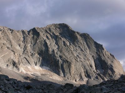
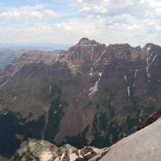
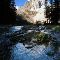
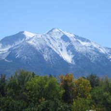
Capitol Peak is a mountain in the Elk Mountains that reaches about 4,300 meters (14,130 feet) high. Its most distinctive feature is a narrow ridge on the northeast side that resembles a knife edge and demands serious climbing skills.

The mountain was first climbed in 1909 by Percy Hagerman and Harold Clark, marking the initial recorded ascent. Since then it has become known as a technically demanding summit.

The mountain received its name due to its resemblance to the United States Capitol building dome, reflecting American architectural influences in geographical naming.

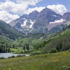
Visitors should come between July and September when conditions are most favorable and snow has melted away. For multiday trips in the Maroon Bells-Snowmass Wilderness, advance planning and proper gear are necessary.

The mountain rises approximately 2,300 meters (7,500 feet) above Roaring Fork Valley, creating one of the steepest elevations in Colorado. This extreme height difference makes the view from the valley floor especially striking.

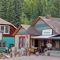
The community of curious travelers

AroundUs brings together thousands of curated places, local tips, and hidden gems, enriched daily by 60,000 contributors worldwide.

Start exploring
Location
Elevation above the sea
4,307 m
GPS coordinates
39.15021,-107.08273
Latest update
December 7, 2025 20:23
Around this place
Maroon Bells
United States of America

Maroon Bells

12 km
Pyramid Peak
United States of America

Pyramid Peak

14.4 km
Redstone Coke Oven Historic District
United States of America

Redstone Coke Oven Historic District

14.1 km
Redstone Castle
United States of America

Redstone Castle

13.9 km
Maroon Bells–Snowmass Wilderness
United States of America

Maroon Bells–Snowmass Wilderness

10.3 km
McClure Pass
United States of America

McClure Pass

17.5 km
Wheeler Opera House
United States of America

Wheeler Opera House

23.1 km
Redstone Historic District
United States of America

Redstone Historic District

13.9 km
Snowmass Peak
United States of America

Snowmass Peak

4.9 km
Pioneer Park
United States of America

Pioneer Park

22.6 km
Aspen Community Church
United States of America

Aspen Community Church

23.1 km
Maroon Creek Bridge
United States of America

Maroon Creek Bridge

21 km
Wheeler–Stallard House
United States of America

Wheeler–Stallard House

22.4 km
D.E. Frantz House
United States of America

D.E. Frantz House

22.7 km
Davis Waite House
United States of America

Davis Waite House

22.9 km
Holden/Marolt Mining and Ranching Museum
United States of America

Holden/Marolt Mining and Ranching Museum

21.9 km
Marble Community Church
United States of America

Marble Community Church

12.7 km
Newberry House
United States of America

Newberry House

23 km
Matthew Callahan Log Cabin
United States of America

Matthew Callahan Log Cabin

22.6 km
Osgood Gamekeeper's Lodge
United States of America

Osgood Gamekeeper's Lodge

14.2 km
Marble High School
United States of America

Marble High School

12.9 km
Bowles–Cooley House
United States of America

Bowles–Cooley House

22.9 km
Shilling–Lamb House
United States of America

Shilling–Lamb House

22.9 km
Samuel I. Hallett House
United States of America

Samuel I. Hallett House

22.7 km
Smith–Elisha House
United States of America

Smith–Elisha House

22.7 km
Osgood–Kuhnhausen House
United States of America

Osgood–Kuhnhausen House

13.7 km
Dixon–Markle House
United States of America

Dixon–Markle House

22.9 km
Mount Sopris
United States of America

Mount Sopris

14.2 km
Show the full map
Reviews
Share your experience

No review yet

Discussions
Start a discussion...

No discussion yet

« Capitol Peak - Mountain peak in Pitkin County, Colorado, US » is provided by Around Us (aroundus.com). Images and texts are derived from Wikimedia project under a Creative Commons license. You are allowed to copy, distribute, and modify copies of this page, under the conditions set by the license, as long as this note is clearly visible.

Discover hidden gems everywhere you go!

From secret cafés to breathtaking viewpoints, skip the crowded tourist spots and find places that match your style. Our app makes it easy with voice search, smart filtering, route optimization, and insider tips from travelers worldwide. Download now for the complete mobile experience.

Around Us App Screenshot

A unique approach to discovering new places

Le Figaro

All the places worth exploring

France Info

A tailor-made excursion in just a few clicks

20 Minutes

Around Us
Travel Guide & Maps
Download

Send to your phone

QR Code
1

Open the camera app on your mobile.

2

Point at the QR code with your camera. A notification will appear.

3

Tap the notification to open the link.