Monument Rock Wilderness

Log in to your account

AroundUs is a community-driven map of interesting places, built by curious explorers like you. It grows with every review, story, and photo you share.
Connect to save your favorite spots, contribute locations, and create personalized routes.
By continuing, you accept our Terms and Conditions and our Privacy Policy

Monument Rock Wilderness

Add to collection
Map
Suggest a change
Share

Monument Rock Wilderness, Protected wilderness area in eastern Oregon, United States.
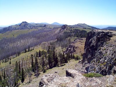
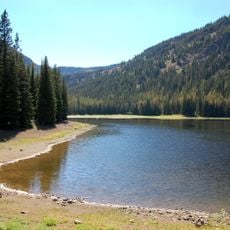
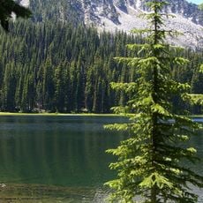
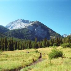
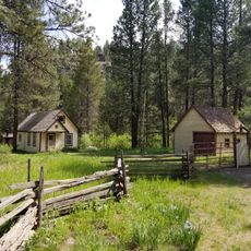
Monument Rock Wilderness spans across rugged terrain with steep cliffs, deep canyons, and dense forests containing ponderosa pine, Douglas fir, and white fir trees.

The United States Congress designated Monument Rock Wilderness in 1984 as part of the National Wilderness Preservation System to protect its natural resources.

Native American tribes utilized the land's resources throughout history, establishing connections with the landscape through hunting and gathering activities.

Visitors can explore 15 miles of marked trails, including the two-mile Bullrun Rock Trail, which leads to numerous geological formations and viewpoints.

The wilderness contains headwaters of the Little Malheur River and South Fork Burnt River, with elevations ranging from 5,120 to 7,815 feet.

Location: Oregon

Inception: 1984

GPS coordinates: 44.30970,-118.30000

Latest update: March 6, 2025 16:48

Around this place
Show the full map
Sumpter Valley Gold Dredge
United States of America

Sumpter Valley Gold Dredge

48.8 km
Geiser Grand Hotel
United States of America

Geiser Grand Hotel

64 km
Kam Wah Chung Company Building
United States of America

Kam Wah Chung Company Building

53.7 km
Sumpter Valley Railway
United States of America

Sumpter Valley Railway

46.1 km
Strawberry Mountain Wilderness
United States of America

Strawberry Mountain Wilderness

39.3 km
National Historic Oregon Trail Interpretive Center
United States of America

National Historic Oregon Trail Interpretive Center

72.2 km
North Fork John Day Wilderness
United States of America

North Fork John Day Wilderness

71.2 km
Unity Lake State Recreation Site
United States of America

Unity Lake State Recreation Site

22.9 km
Rock Creek Butte
United States of America

Rock Creek Butte

58.6 km
Baker City Tower
United States of America

Baker City Tower

63.8 km
Clyde Holliday State Recreation Site
United States of America

Clyde Holliday State Recreation Site

63.8 km
Cathedral of Saint Francis de Sales
United States of America

Cathedral of Saint Francis de Sales

64.2 km
Bully Creek Reservoir
United States of America

Bully Creek Reservoir

79.4 km
Unity Ranger Station
United States of America

Unity Ranger Station

16.6 km
Moses and Mary Hart Stone House and Ranch Complex
United States of America

Moses and Mary Hart Stone House and Ranch Complex

58.9 km
Antlers Guard Station
United States of America

Antlers Guard Station

36.1 km
Baker Historic District
United States of America

Baker Historic District

64 km
Advent Christian Church
United States of America

Advent Christian Church

53.4 km
Baker Municipal Natatorium
United States of America

Baker Municipal Natatorium

64.7 km
Churchill School
United States of America

Churchill School

63.2 km
St. Thomas' Episcopal Church
United States of America

St. Thomas' Episcopal Church

52.3 km
Supervisor's House No. 1001
United States of America

Supervisor's House No. 1001

53.1 km
John Day Compound
United States of America

John Day Compound

53.9 km
Superintendent's House
United States of America

Superintendent's House

49 km
Kam Wah Chung State Heritage Site
United States of America

Kam Wah Chung State Heritage Site

53.6 km
McEwen
United States of America

McEwen

46.1 km
Kam Wah Chung Chinese Heritage Site
United States of America

Kam Wah Chung Chinese Heritage Site

53.5 km
Eltrym Theater
United States of America

Eltrym Theater

63.8 km
Show the full map

Reviews

Visited this place? Tap the stars to rate it and share your experience / photos with the community! Try now! You can cancel it anytime.

« Monument Rock Wilderness - Protected wilderness area in eastern Oregon, United States » is provided by Around Us (aroundus.com). Images and texts are derived from Wikimedia project under a Creative Commons license. You are allowed to copy, distribute, and modify copies of this page, under the conditions set by the license, as long as this note is clearly visible.

Discover hidden gems everywhere you go!

From secret cafés to breathtaking viewpoints, skip the crowded tourist spots and find places that match your style. Our app makes it easy with voice search, smart filtering, route optimization, and insider tips from travelers worldwide. Download now for the complete mobile experience.

Around Us App Screenshot

A unique approach to discovering new places

Le Figaro

All the places worth exploring

France Info

A tailor-made excursion in just a few clicks

20 Minutes