Enable Location

We need your location to show you interesting places around you

Discover nearby places

Find interesting locations and hidden gems around you

Precise directions

Get accurate directions and distances to places

Your location is never shared with other users. It's only used when you tap the location button.

Unity Ranger Station

Log in to your account

Join the adventure

Create your free account and start exploring

Save your favorite places
Create custom travel routes
Rate and review places
Access the full interactive map
Continue with Google
Continue with Apple
Continue with email
By continuing, you accept our Terms and Conditions and our Privacy Policy
Create an account

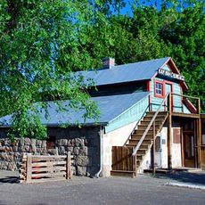
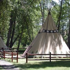
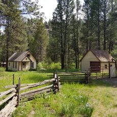
Unity Ranger Station, Historic ranger station in Baker County, Oregon.

Description

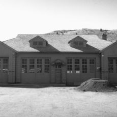
The Unity Ranger Station comprises five primary buildings and a 60-foot fire lookout tower constructed in rustic architectural style using native lava stone, wood framing, and wooden shingles that harmonize with the surrounding Wallowa-Whitman National Forest landscape.

History

Built between 1936 and 1938 by Civilian Conservation Corps crews, the station served as the administrative center for the Unity Ranger District covering approximately 194,000 acres until road improvements led to its closure as a district headquarters in 2002.

Culture

The station exemplifies the rustic architectural movement that emphasized harmony with natural landscapes, featuring decorative pine tree logos on gable ends and native materials that reflect the pioneering spirit of early forest service conservation efforts.

Practical

Located at coordinates 44.4354°N latitude and -118.187°W longitude at 4,038 feet elevation, the station is accessible via Oregon Route 245 from Baker City and currently houses Forest Service fire crews during summer months.

Did you know?

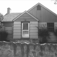
The station contains two ranger residences including one building moved from another research station in 1953, making it a rare example of relocated Forest Service architecture that maintains its original rustic design integrity.

i
Location
i
Architects
United States Forest Service
i
Architectural style
rustic architecture
i
GPS coordinates
44.43540,-118.18700
i
Latest update
July 24, 2025 11:53

AroundUs brings together thousands of curated places, local tips, and hidden gems, enriched daily by 60,000 contributors worldwide. Discover all places nearby (Baker County).

Around this place
Sumpter Valley Gold Dredge
United States of America

Sumpter Valley Gold Dredge

34.2 km
Geiser Grand Hotel
United States of America

Geiser Grand Hotel

47.4 km
Kam Wah Chung Company Building
United States of America

Kam Wah Chung Company Building

61.2 km
Sumpter Valley Railway
United States of America

Sumpter Valley Railway

30.3 km
Strawberry Mountain Wilderness
United States of America

Strawberry Mountain Wilderness

50.4 km
National Historic Oregon Trail Interpretive Center
United States of America

National Historic Oregon Trail Interpretive Center

55.7 km
North Fork John Day Wilderness
United States of America

North Fork John Day Wilderness

62.1 km
Unity Lake State Recreation Site
United States of America

Unity Lake State Recreation Site

7.1 km
Rock Creek Butte
United States of America

Rock Creek Butte

43 km
Monument Rock Wilderness
United States of America

Monument Rock Wilderness

16.6 km
Baker City Tower
United States of America

Baker City Tower

47.2 km
Clyde Holliday State Recreation Site
United States of America

Clyde Holliday State Recreation Site

71.7 km
Cathedral of Saint Francis de Sales
United States of America

Cathedral of Saint Francis de Sales

47.6 km
Moses and Mary Hart Stone House and Ranch Complex
United States of America

Moses and Mary Hart Stone House and Ranch Complex

62.7 km
Antlers Guard Station
United States of America

Antlers Guard Station

23.2 km
Baker Historic District
United States of America

Baker Historic District

47.4 km
Thief Valley Reservoir
United States of America

Thief Valley Reservoir

72.5 km
Advent Christian Church
United States of America

Advent Christian Church

61 km
Baker Municipal Natatorium
United States of America

Baker Municipal Natatorium

48.1 km
Churchill School
United States of America

Churchill School

46.6 km
St. Thomas' Episcopal Church
United States of America

St. Thomas' Episcopal Church

60.7 km
Wolf Creek Reservoir
United States of America

Wolf Creek Reservoir

70.3 km
Supervisor's House No. 1001
United States of America

Supervisor's House No. 1001

60.7 km
John Day Compound
United States of America

John Day Compound

61.5 km
Superintendent's House
United States of America

Superintendent's House

34.4 km
Kam Wah Chung State Heritage Site
United States of America

Kam Wah Chung State Heritage Site

61.2 km
McEwen
United States of America

McEwen

30.3 km
Kam Wah Chung Chinese Heritage Site
United States of America

Kam Wah Chung Chinese Heritage Site

61.1 km
Show the full map
Reviews

Visited this place? Tap the stars to rate it and share your experience / photos with the community! Try now! You can cancel it anytime.

« Unity Ranger Station - Historic ranger station in Baker County, Oregon » is provided by Around Us (aroundus.com). Images and texts are derived from Wikimedia project under a Creative Commons license. You are allowed to copy, distribute, and modify copies of this page, under the conditions set by the license, as long as this note is clearly visible.

Discover hidden gems everywhere you go!

From secret cafés to breathtaking viewpoints, skip the crowded tourist spots and find places that match your style. Our app makes it easy with voice search, smart filtering, route optimization, and insider tips from travelers worldwide. Download now for the complete mobile experience.

Around Us App Screenshot

A unique approach to discovering new places

Le Figaro

All the places worth exploring

France Info

A tailor-made excursion in just a few clicks

20 Minutes