Enable Location

We need your location to show you interesting places around you

Discover nearby places

Find interesting locations and hidden gems around you

Precise directions

Get accurate directions and distances to places

Your location is never shared with other users. It's only used when you tap the location button.

Rock Creek Butte

Log in to your account

Start exploring — it's free

Trusted by 63,056 travelers worldwide

Continue with Google
Continue with Apple
or

We will send you a code to connect

By continuing, you accept our Terms and Conditions and our Privacy Policy

Check your inbox

We've sent a pincode in your inbox. Please enter the code below.

Rock Creek Butte
Discussion Reviews 1 Photos
2.7k Popularity

Rock Creek Butte, Mountain summit in Baker County, United States.

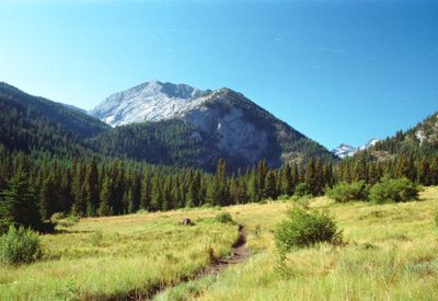
Rock Creek Butte is a mountain summit reaching 9,106 feet (2,776 m) and the highest peak in the Blue Mountains. Its steep slopes are covered with pine and Douglas fir trees that create its distinctive forest character.

The area gained attention in 1862 after gold was discovered nearby, sparking the rise of several mining settlements. Auburn, Sumpter, and Granite were established as a result of this mining boom in the region.

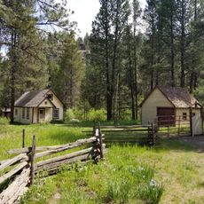
The mountain serves as a focal point within the Wallowa-Whitman National Forest, where visitors encounter seasonal hunting and wildlife observation practices. These activities shape how people connect with and use this landscape throughout the year.

The climb is accessed via the Elkhorn Ridge trail system with a round trip of about 11 miles (18 km) and elevation gain around 3,700 feet (1,130 m). Visitors should come prepared with sturdy hiking boots and plenty of water, as the terrain is demanding.

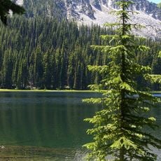
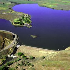
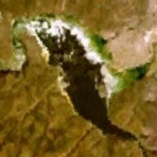
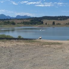
Twin Lakes sit on the southern slope while Rock Creek Lake and Bucket Lake occupy the northern side. These four water bodies shape the landscape and offer spots for nature observation around the mountain.

The community of curious travelers

AroundUs brings together thousands of curated places, local tips, and hidden gems, enriched daily by 60,000 contributors worldwide.

Start exploring
Location
GPS coordinates
44.81700,-118.10400
Latest update
December 12, 2025 16:43
Around this place
Sumpter Valley Gold Dredge
United States of America

Sumpter Valley Gold Dredge

11.5 km
Geiser Grand Hotel
United States of America

Geiser Grand Hotel

22.2 km
Sumpter Valley Railway
United States of America

Sumpter Valley Railway

12.7 km
National Historic Oregon Trail Interpretive Center
United States of America

National Historic Oregon Trail Interpretive Center

29.6 km
North Fork John Day Wilderness
United States of America

North Fork John Day Wilderness

39.5 km
Unity Lake State Recreation Site
United States of America

Unity Lake State Recreation Site

36 km
Catherine Creek State Park
United States of America

Catherine Creek State Park

47.3 km
Baker City Tower
United States of America

Baker City Tower

22.1 km
Cathedral of Saint Francis de Sales
United States of America

Cathedral of Saint Francis de Sales

22 km
Red Bridge State Wayside
United States of America

Red Bridge State Wayside

55.6 km
Unity Ranger Station
United States of America

Unity Ranger Station

43 km
Antlers Guard Station
United States of America

Antlers Guard Station

24.7 km
Baker Historic District
United States of America

Baker Historic District

22.1 km
Thief Valley Reservoir
United States of America

Thief Valley Reservoir

33.4 km
Abel E. Eaton House
United States of America

Abel E. Eaton House

47.8 km
Baker Municipal Natatorium
United States of America

Baker Municipal Natatorium

22.5 km
John Anthony House
United States of America

John Anthony House

56.6 km
Churchill School
United States of America

Churchill School

20.6 km
Inlow Hall
United States of America

Inlow Hall

56.2 km
Wolf Creek Reservoir
United States of America

Wolf Creek Reservoir

27.4 km
Liberty Theater
United States of America

Liberty Theater

57 km
Anthony–Buckley House
United States of America

Anthony–Buckley House

56.6 km
Superintendent's House
United States of America

Superintendent's House

11.2 km
U.S. Post Office and Federal Building
United States of America

U.S. Post Office and Federal Building

57 km
McEwen
United States of America

McEwen

12.7 km
Eltrym Theater
United States of America

Eltrym Theater

22 km
Gardner Building
United States of America

Gardner Building

56.9 km
Granada 3 Theatre
United States of America

Granada 3 Theatre

56.9 km
Show the full map
Reviews
Share your experience

No review yet

Discussions
Start a discussion...

No discussion yet

« Rock Creek Butte - Mountain summit in Baker County, United States » is provided by Around Us (aroundus.com). Images and texts are derived from Wikimedia project under a Creative Commons license. You are allowed to copy, distribute, and modify copies of this page, under the conditions set by the license, as long as this note is clearly visible.

Discover hidden gems everywhere you go!

From secret cafés to breathtaking viewpoints, skip the crowded tourist spots and find places that match your style. Our app makes it easy with voice search, smart filtering, route optimization, and insider tips from travelers worldwide. Download now for the complete mobile experience.

Around Us App Screenshot

A unique approach to discovering new places

Le Figaro

All the places worth exploring

France Info

A tailor-made excursion in just a few clicks

20 Minutes

Around Us
Travel Guide & Maps
Download

Send to your phone

QR Code
1

Open the camera app on your mobile.

2

Point at the QR code with your camera. A notification will appear.

3

Tap the notification to open the link.