Enable Location

We need your location to show you interesting places around you

Discover nearby places

Find interesting locations and hidden gems around you

Precise directions

Get accurate directions and distances to places

Your location is never shared with other users. It's only used when you tap the location button.

Log in to your account

Start exploring — it's free

Trusted by 61,564 travelers worldwide

Continue with Google
Continue with Apple
or

We will send you a code to connect

By continuing, you accept our Terms and Conditions and our Privacy Policy

Check your inbox

We've sent a pincode in your inbox. Please enter the code below.

Unity Forest State Scenic Corridor

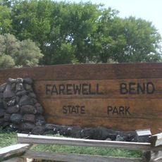
Unity Forest State Scenic Corridor, State park in Baker County, Oregon, US

Description

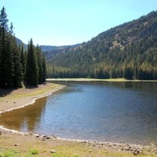
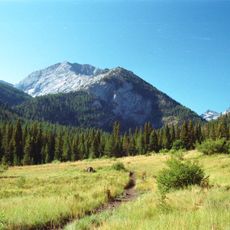
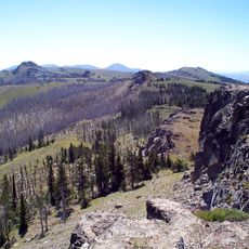
Unity Forest State Scenic Corridor is a woodland corridor in Baker County that winds through dense ponderosa pine forests with multiple trails for visitors to explore. The landscape features varied elevation and mixed forest conditions that create habitat for numerous animal species across its routes.

History

The corridor was established by Oregon Parks and Recreation Department as part of the state's mission to protect natural forest landscapes. This creation reflects decades of effort to maintain accessible outdoor spaces for residents and visitors across eastern Oregon.

Culture

The forest corridor represents Oregon's dedication to maintaining public access to natural spaces through the state park system.

Practical

Hiking the designated trails offers the most straightforward way to experience the forest, with routes passing through different sections of varying terrain. Visitors should dress appropriately for forest conditions and plan visits during daylight hours when wildlife sightings are easier to manage safely.

Did you know?

The corridor's location near Unity Lake State Recreation Site creates a network of outdoor spaces within a 10-mile radius.

Location
GPS coordinates
44.37130,-118.11300
Latest update
December 14, 2025 11:23

AroundUs brings together thousands of curated places, local tips, and hidden gems, enriched daily by 60,000 contributors worldwide. Discover all places nearby (Oregon).

Around this place
Sumpter Valley Gold Dredge
United States of America

Sumpter Valley Gold Dredge

42 km
Geiser Grand Hotel
United States of America

Geiser Grand Hotel

50.4 km
Kam Wah Chung Company Building
United States of America

Kam Wah Chung Company Building

67.3 km
Sumpter Valley Railway
United States of America

Sumpter Valley Railway

37 km
Farewell Bend State Recreation Area
United States of America

Farewell Bend State Recreation Area

71.2 km
Strawberry Mountain Wilderness
United States of America

Strawberry Mountain Wilderness

54.7 km
National Historic Oregon Trail Interpretive Center
United States of America

National Historic Oregon Trail Interpretive Center

58 km
Unity Lake State Recreation Site
United States of America

Unity Lake State Recreation Site

15.4 km
Rock Creek Butte
United States of America

Rock Creek Butte

49.6 km
Monument Rock Wilderness
United States of America

Monument Rock Wilderness

16.4 km
Baker City Tower
United States of America

Baker City Tower

50.2 km
Cathedral of Saint Francis de Sales
United States of America

Cathedral of Saint Francis de Sales

50.6 km
Bully Creek Reservoir
United States of America

Bully Creek Reservoir

69.7 km
Unity Ranger Station
United States of America

Unity Ranger Station

9.2 km
Moses and Mary Hart Stone House and Ranch Complex
United States of America

Moses and Mary Hart Stone House and Ranch Complex

53.5 km
Antlers Guard Station
United States of America

Antlers Guard Station

32 km
Baker Historic District
United States of America

Baker Historic District

50.4 km
Advent Christian Church
United States of America

Advent Christian Church

67.1 km
Baker Municipal Natatorium
United States of America

Baker Municipal Natatorium

51.1 km
Fremont Powerhouse
United States of America

Fremont Powerhouse

56.3 km
Churchill School
United States of America

Churchill School

49.8 km
St. Thomas' Episcopal Church
United States of America

St. Thomas' Episcopal Church

66.4 km
Supervisor's House No. 1001
United States of America

Supervisor's House No. 1001

66.8 km
Oregon Commercial Company Building
United States of America

Oregon Commercial Company Building

67.4 km
John Day Compound
United States of America

John Day Compound

67.6 km
Superintendent's House
United States of America

Superintendent's House

42.1 km
Kam Wah Chung State Heritage Site
United States of America

Kam Wah Chung State Heritage Site

67.3 km
McEwen
United States of America

McEwen

37 km
Show the full map
« Unity Forest State Scenic Corridor - State park in Baker County, Oregon, US » is provided by Around Us (aroundus.com). Images and texts are derived from Wikimedia project under a Creative Commons license. You are allowed to copy, distribute, and modify copies of this page, under the conditions set by the license, as long as this note is clearly visible.

Discover hidden gems everywhere you go!

From secret cafés to breathtaking viewpoints, skip the crowded tourist spots and find places that match your style. Our app makes it easy with voice search, smart filtering, route optimization, and insider tips from travelers worldwide. Download now for the complete mobile experience.

Around Us App Screenshot

A unique approach to discovering new places

Le Figaro

All the places worth exploring

France Info

A tailor-made excursion in just a few clicks

20 Minutes

Around Us
Travel Guide & Maps
Download

Send to your phone

QR Code
1

Open the camera app on your mobile.

2

Point at the QR code with your camera. A notification will appear.

3

Tap the notification to open the link.