Lake Owyhee State Park

Log in to your account

AroundUs is a community-driven map of interesting places, built by curious explorers like you. It grows with every review, story, and photo you share.
Connect to save your favorite spots, contribute locations, and create personalized routes.
Continue with Google
Continue with Apple
Continue with X
Continue with Facebook
Continue with email
By continuing, you accept our Terms and Conditions and our Privacy Policy
Create an account
Add to collection
Map
Suggest a change
Share

Lake Owyhee State Park, State park and reservoir in Malheur County, Oregon, United States.

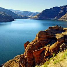
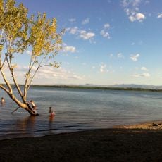
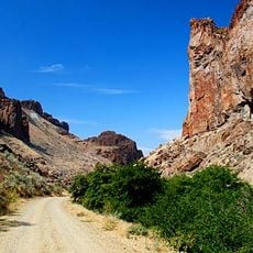
Lake Owyhee State Park spans 2,000 acres (809 hectares) along a 53-mile (85 kilometer) reservoir nestled within deep canyons carved by volcanic rock. The water sits surrounded by steep canyon walls where multicolored lava layers and reddish-orange rock formations define the landscape.

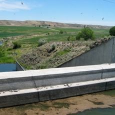
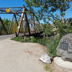
The Owyhee Dam was completed in 1932, creating the reservoir system that has provided irrigation for agricultural development across eastern Oregon. The structure marked a turning point in the economic use of this remote desert region.

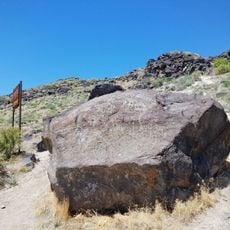
The name Owyhee honors Hawaiian workers who died during a Hudson's Bay Company expedition in this region in 1819. This naming tradition preserves the memory of early encounters between European traders and people of the Pacific region.

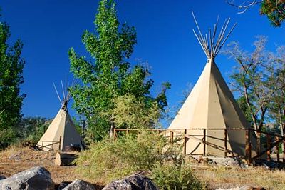
The park has two campgrounds with electrical hookups, boat ramps, and water facilities, typically open from April through October. Visitors should check weather conditions and expect extreme heat and limited shade at this desert location.

The most striking rock formations are only reachable by boat and reveal fascinating color contrasts in the canyon walls created by different phases of volcanic activity. This water route exposes layers and color shifts that remain completely hidden from the shore.

Location: Oregon

Website: https://stateparks.oregon.gov/index.cfm?do=park.profile&parkId=10

GPS coordinates: 43.61990,-117.23700

Latest update: December 12, 2025 09:04

Photos
Around this place
Fort Boise
United States of America

Fort Boise

28.6 km
Jump Creek Falls
United States of America

Jump Creek Falls

29.8 km
Owyhee Reservoir
United States of America

Owyhee Reservoir

19.4 km
Deer Flat National Wildlife Refuge
United States of America

Deer Flat National Wildlife Refuge

46.6 km
Succor Creek State Natural Area
United States of America

Succor Creek State Natural Area

19 km
Bully Creek Reservoir
United States of America

Bully Creek Reservoir

45.6 km
Simplot Stadium
United States of America

Simplot Stadium

45.8 km
Map Rock Petroglyphs Historic District
United States of America

Map Rock Petroglyphs Historic District

48.4 km
Boise River and Canal Bridge
United States of America

Boise River and Canal Bridge

45 km
Caldwell Historic District
United States of America

Caldwell Historic District

44.5 km
Al Thompson and Son's Feed and Seed Company
United States of America

Al Thompson and Son's Feed and Seed Company

34.5 km
Rinehart Stone House Museum
United States of America

Rinehart Stone House Museum

40.2 km
New Plymouth Congregational Church
United States of America

New Plymouth Congregational Church

51.4 km
A. K. Steunenberg House
United States of America

A. K. Steunenberg House

45 km
George Obendorf Gothic Arch Truss Barn
United States of America

George Obendorf Gothic Arch Truss Barn

27.7 km
St. Mary's Catholic Church
United States of America

St. Mary's Catholic Church

44.2 km
Vale Hotel and Grand Opera House
United States of America

Vale Hotel and Grand Opera House

40.3 km
Blatchley Hall
United States of America

Blatchley Hall

45.5 km
Henry W. and Ida Frost Dorman House
United States of America

Henry W. and Ida Frost Dorman House

43.8 km
Caldwell Carnegie Library
United States of America

Caldwell Carnegie Library

44.7 km
F. F. Beale House
United States of America

F. F. Beale House

45.1 km
John C. Rice House
United States of America

John C. Rice House

45 km
First Bank of Vale
United States of America

First Bank of Vale

40.3 km
Thomas K. Little House
United States of America

Thomas K. Little House

44.8 km
James Rowley and Mary J. Blackaby House
United States of America

James Rowley and Mary J. Blackaby House

49.6 km
Sterry Hall
United States of America

Sterry Hall

45.4 km
Vinsonhaler Blacksmith Shop
United States of America

Vinsonhaler Blacksmith Shop

34.6 km
Reel Theatre 8
United States of America

Reel Theatre 8

50.5 km
Show the full map
Reviews

Visited this place? Tap the stars to rate it and share your experience / photos with the community! Try now! You can cancel it anytime.

« Lake Owyhee State Park - State park and reservoir in Malheur County, Oregon, United States » is provided by Around Us (aroundus.com). Images and texts are derived from Wikimedia project under a Creative Commons license. You are allowed to copy, distribute, and modify copies of this page, under the conditions set by the license, as long as this note is clearly visible.

Discover hidden gems everywhere you go!

From secret cafés to breathtaking viewpoints, skip the crowded tourist spots and find places that match your style. Our app makes it easy with voice search, smart filtering, route optimization, and insider tips from travelers worldwide. Download now for the complete mobile experience.

Around Us App Screenshot

A unique approach to discovering new places

Le Figaro

All the places worth exploring

France Info

A tailor-made excursion in just a few clicks

20 Minutes