Enable Location

We need your location to show you interesting places around you

Discover nearby places

Find interesting locations and hidden gems around you

Precise directions

Get accurate directions and distances to places

Your location is never shared with other users. It's only used when you tap the location button.

Owyhee Reservoir

Log in to your account

Start exploring — it's free

Trusted by 62,324 travelers worldwide

Continue with Google
Continue with Apple
or

We will send you a code to connect

By continuing, you accept our Terms and Conditions and our Privacy Policy

Check your inbox

We've sent a pincode in your inbox. Please enter the code below.

Owyhee Reservoir

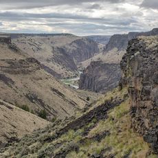
Owyhee Reservoir, body of water

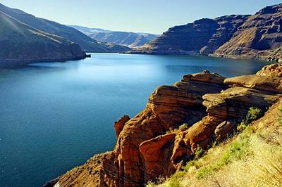
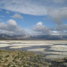
Owyhee Reservoir is a large body of water in eastern Oregon stretching roughly 53 miles through rugged landscape. The water sits surrounded by steep canyons and volcanic rock formations, with an open desert terrain on all sides.

Owyhee Reservoir was created in 1932 when the Owyhee Dam was built during the Great Depression. The massive concrete structure became a model for later dam engineering and was originally designed to supply water for farming irrigation.

The reservoir takes its name from the Owyhee River, formed where three streams converge. The area draws visitors seeking solitude and a direct connection with the natural landscape away from development.

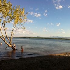
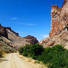
Access is easiest from Adrian following rural roads, with high-clearance vehicles recommended especially after rain. Boat ramps on the northern end near the dam and another at Leslie Gulch allow water access for fishing and recreation.

The Owyhee Dam was an early milestone in concrete engineering and served as a model for later structures like Hoover Dam. Visitors can explore the dam's visitor center to learn how this engineering feat was accomplished.

The community of curious travelers

AroundUs brings together thousands of curated places, local tips, and hidden gems, enriched daily by 60,000 contributors worldwide.

Start exploring
Location
GPS coordinates
43.46139,-117.33833
Latest update
February 7, 2026 11:01
Around this place
Fort Boise
United States of America

Fort Boise

47.8 km
Jump Creek Falls
United States of America

Jump Creek Falls

33.4 km
Deer Flat National Wildlife Refuge
United States of America

Deer Flat National Wildlife Refuge

55.1 km
Northern Basin and Range ecoregion
United States of America

Northern Basin and Range ecoregion

58.2 km
Lake Owyhee State Park
United States of America

Lake Owyhee State Park

19.4 km
Succor Creek State Natural Area
United States of America

Succor Creek State Natural Area

16.5 km
Simplot Stadium
United States of America

Simplot Stadium

57.9 km
Map Rock Petroglyphs Historic District
United States of America

Map Rock Petroglyphs Historic District

51.5 km
Boise River and Canal Bridge
United States of America

Boise River and Canal Bridge

58.3 km
Caldwell Historic District
United States of America

Caldwell Historic District

57.2 km
Al Thompson and Son's Feed and Seed Company
United States of America

Al Thompson and Son's Feed and Seed Company

53.8 km
Rinehart Stone House Museum
United States of America

Rinehart Stone House Museum

58.4 km
A. K. Steunenberg House
United States of America

A. K. Steunenberg House

57.7 km
George Obendorf Gothic Arch Truss Barn
United States of America

George Obendorf Gothic Arch Truss Barn

44.2 km
St. Mary's Catholic Church
United States of America

St. Mary's Catholic Church

56.9 km
Vale Hotel and Grand Opera House
United States of America

Vale Hotel and Grand Opera House

58.5 km
Blatchley Hall
United States of America

Blatchley Hall

57.6 km
Henry W. and Ida Frost Dorman House
United States of America

Henry W. and Ida Frost Dorman House

56.1 km
Caldwell Carnegie Library
United States of America

Caldwell Carnegie Library

57.2 km
F. F. Beale House
United States of America

F. F. Beale House

57.4 km
John C. Rice House
United States of America

John C. Rice House

57.4 km
First Bank of Vale
United States of America

First Bank of Vale

58.5 km
Thomas K. Little House
United States of America

Thomas K. Little House

57.6 km
Sterry Hall
United States of America

Sterry Hall

57.6 km
Vinsonhaler Blacksmith Shop
United States of America

Vinsonhaler Blacksmith Shop

53.9 km
Noble Horse Barn
United States of America

Noble Horse Barn

54.6 km
Rex Theater
United States of America

Rex Theater

58.5 km
Owyhee Canyon
United States of America

Owyhee Canyon

37 km
Show the full map
« Owyhee Reservoir - body of water » is provided by Around Us (aroundus.com). Images and texts are derived from Wikimedia project under a Creative Commons license. You are allowed to copy, distribute, and modify copies of this page, under the conditions set by the license, as long as this note is clearly visible.

Discover hidden gems everywhere you go!

From secret cafés to breathtaking viewpoints, skip the crowded tourist spots and find places that match your style. Our app makes it easy with voice search, smart filtering, route optimization, and insider tips from travelers worldwide. Download now for the complete mobile experience.

Around Us App Screenshot

A unique approach to discovering new places

Le Figaro

All the places worth exploring

France Info

A tailor-made excursion in just a few clicks

20 Minutes

Around Us
Travel Guide & Maps
Download

Send to your phone

QR Code
1

Open the camera app on your mobile.

2

Point at the QR code with your camera. A notification will appear.

3

Tap the notification to open the link.