Enable Location

We need your location to show you interesting places around you

Discover nearby places

Find interesting locations and hidden gems around you

Precise directions

Get accurate directions and distances to places

Your location is never shared with other users. It's only used when you tap the location button.

Log in to your account

Start exploring — it's free

Trusted by 62,867 travelers worldwide

Continue with Google
Continue with Apple
or

We will send you a code to connect

By continuing, you accept our Terms and Conditions and our Privacy Policy

Check your inbox

We've sent a pincode in your inbox. Please enter the code below.

Malheur Reservoir

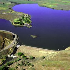
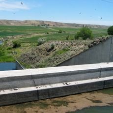
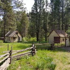
Malheur Reservoir, body of water

Malheur Reservoir is a body of water covering around 2000 acres in northeastern Oregon, situated about 24 kilometers northwest of Brogan. It reaches depths of around 38 feet (11 meters) and receives water from Willow Creek, with a concrete boat ramp and gravel parking area available at the north access point.

The structure was built in the 1930s to store water for agricultural irrigation. Since the 1960s, the lake has been stocked with rainbow trout to support fishing opportunities for local and visiting anglers.

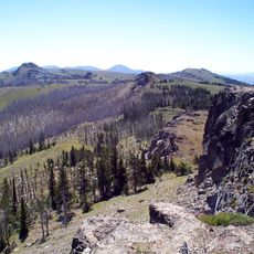
The name comes from Spanish colonial settlers and means "bad luck". For locals and visitors, this place represents a connection to the land and a way to spend time away from settled areas, reflecting how rural communities value direct access to water and open space.

Access is by dirt roads from Route 26, with two main entry points near Ironside to the southwest and Brogan to the southeast. A vault restroom and basic parking are provided, but bring your own gear and supplies since no facilities for food, fuel, or equipment are available on-site.

Water levels fluctuate dramatically based on rainfall and drought cycles, making fishing conditions and visitor experiences vary significantly from year to year. In wet seasons, trout can grow notably large, while dry periods may cause parts of the lake to dry out completely.

The community of curious travelers

AroundUs brings together thousands of curated places, local tips, and hidden gems, enriched daily by 60,000 contributors worldwide.

Start exploring
Location
GPS coordinates
44.36498,-117.69840
Latest update
February 9, 2026 08:19
Around this place
Sumpter Valley Gold Dredge
United States of America

Sumpter Valley Gold Dredge

58.1 km
Geiser Grand Hotel
United States of America

Geiser Grand Hotel

47 km
Sumpter Valley Railway
United States of America

Sumpter Valley Railway

50.5 km
Farewell Bend State Recreation Area
United States of America

Farewell Bend State Recreation Area

38.4 km
National Historic Oregon Trail Interpretive Center
United States of America

National Historic Oregon Trail Interpretive Center

50.1 km
Unity Lake State Recreation Site
United States of America

Unity Lake State Recreation Site

41.6 km
Monument Rock Wilderness
United States of America

Monument Rock Wilderness

48.3 km
Baker City Tower
United States of America

Baker City Tower

46.8 km
Cathedral of Saint Francis de Sales
United States of America

Cathedral of Saint Francis de Sales

47.3 km
Bully Creek Reservoir
United States of America

Bully Creek Reservoir

46 km
Unity Ranger Station
United States of America

Unity Ranger Station

39.6 km
Moses and Mary Hart Stone House and Ranch Complex
United States of America

Moses and Mary Hart Stone House and Ranch Complex

42.7 km
Antlers Guard Station
United States of America

Antlers Guard Station

55 km
Baker Historic District
United States of America

Baker Historic District

47 km
Baker Municipal Natatorium
United States of America

Baker Municipal Natatorium

47.4 km
Rinehart Stone House Museum
United States of America

Rinehart Stone House Museum

56.3 km
Churchill School
United States of America

Churchill School

47.5 km
Intermountain Institute
United States of America

Intermountain Institute

58.2 km
Vale Hotel and Grand Opera House
United States of America

Vale Hotel and Grand Opera House

55.9 km
Oregon Commercial Company Building
United States of America

Oregon Commercial Company Building

34.4 km
First Bank of Vale
United States of America

First Bank of Vale

56.3 km
Vale Drug Store
United States of America

Vale Drug Store

56.2 km
B. S. Varian House
United States of America

B. S. Varian House

59.2 km
Superintendent's House
United States of America

Superintendent's House

58.1 km
James M. Fisher House
United States of America

James M. Fisher House

58.8 km
Morris Sommer House
United States of America

Morris Sommer House

59.3 km
Benjamin Watlington House
United States of America

Benjamin Watlington House

59.3 km
McEwen
United States of America

McEwen

50.3 km
Show the full map
« Malheur Reservoir - body of water » is provided by Around Us (aroundus.com). Images and texts are derived from Wikimedia project under a Creative Commons license. You are allowed to copy, distribute, and modify copies of this page, under the conditions set by the license, as long as this note is clearly visible.

Discover hidden gems everywhere you go!

From secret cafés to breathtaking viewpoints, skip the crowded tourist spots and find places that match your style. Our app makes it easy with voice search, smart filtering, route optimization, and insider tips from travelers worldwide. Download now for the complete mobile experience.

Around Us App Screenshot

A unique approach to discovering new places

Le Figaro

All the places worth exploring

France Info

A tailor-made excursion in just a few clicks

20 Minutes

Around Us
Travel Guide & Maps
Download

Send to your phone

QR Code
1

Open the camera app on your mobile.

2

Point at the QR code with your camera. A notification will appear.

3

Tap the notification to open the link.