Enable Location

We need your location to show you interesting places around you

Discover nearby places

Find interesting locations and hidden gems around you

Precise directions

Get accurate directions and distances to places

Your location is never shared with other users. It's only used when you tap the location button.

Leesburg, Idaho

Log in to your account

Start exploring — it's free

Trusted by 62,331 travelers worldwide

Continue with Google
Continue with Apple
or

We will send you a code to connect

By continuing, you accept our Terms and Conditions and our Privacy Policy

Check your inbox

We've sent a pincode in your inbox. Please enter the code below.

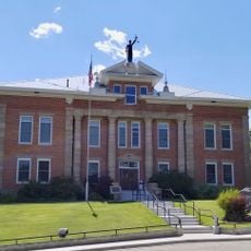
Leesburg, Idaho, human settlement in Lemhi County, Idaho, United States of America

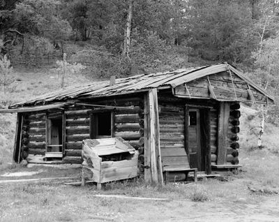
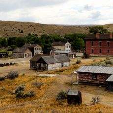
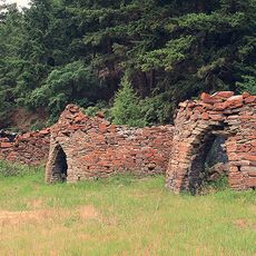
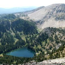
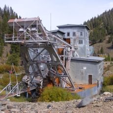
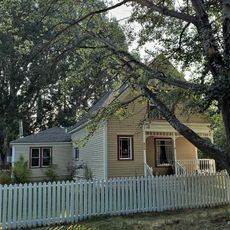
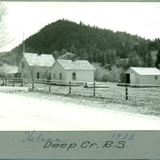
Leesburg is a ghost town in Lemhi County, Idaho, located at high elevation with very few buildings remaining today. It grew rapidly after gold was discovered in 1866, with miners constructing some 40 buildings including stores, butcher shops, a blacksmith shop, and stables to support the workers.

F.B. Sharkey and his team discovered gold along Napias Creek in 1866, triggering rapid settlement with about 2,000 people by summer of that year. The population dropped below 200 by 1870 as gold yields fell short of expectations, and Chinese miners later moved into the area as others departed.

The town was named after General Robert E. Lee, reflecting the sympathies of early residents despite Idaho being a free territory. This choice, along with a nearby settlement called Grantsville, shows how former soldiers from opposite sides of the Civil War found themselves working together in this remote mountain location.

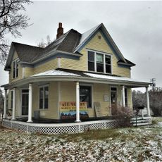
The site is located in a high mountain area with harsh winter conditions, as shown by the heavy snows of 1866-1867, so visiting during warmer months is advisable. The remains are open and accessible, with a few standing structures and old foundations that offer a window into life during the settlement period.

The settlement had an unusual reputation for being peaceful and orderly, with miners known for their honesty who focused on work rather than trouble. In 1926, early residents and their descendants erected a monument with photographs of the first buildings as a way to preserve the memory of those early days.

The community of curious travelers

AroundUs brings together thousands of curated places, local tips, and hidden gems, enriched daily by 60,000 contributors worldwide.

Start exploring
Location
GPS coordinates
45.22389,-114.11389
Latest update
February 9, 2026 08:22
Around this place
Bannack
United States of America

Bannack

87.9 km
Frank Church–River of No Return Wilderness
United States of America

Frank Church–River of No Return Wilderness

68.3 km
Big Hole National Battlefield
United States of America

Big Hole National Battlefield

59.8 km
Goldbug Hot Springs
United States of America

Goldbug Hot Springs

38.4 km
Selway-Bitterroot Wilderness
United States of America

Selway-Bitterroot Wilderness

111.5 km
Clark Canyon Dam
United States of America

Clark Canyon Dam

101.8 km
Custer
United States of America

Custer

103.8 km
Bayhorse
United States of America

Bayhorse

93.3 km
Anaconda-Pintler Wilderness
United States of America

Anaconda-Pintler Wilderness

95.3 km
Land of the Yankee Fork State Park
United States of America

Land of the Yankee Fork State Park

83.6 km
Marcus Daly Memorial Hospital
United States of America

Marcus Daly Memorial Hospital

113.8 km
Oliver Blood House
United States of America

Oliver Blood House

113.4 km
Ravalli County Courthouse
United States of America

Ravalli County Courthouse

113.7 km
Arctic Point Fire Lookout
United States of America

Arctic Point Fire Lookout

77.5 km
Gardiner Peak Lookout
United States of America

Gardiner Peak Lookout

97.4 km
Odd Fellows Hall
United States of America

Odd Fellows Hall

18.2 km
Lemhi County Courthouse
United States of America

Lemhi County Courthouse

17.4 km
Charles Granke House
United States of America

Charles Granke House

113.5 km
Deep Creek Ranger Station
United States of America

Deep Creek Ranger Station

71.3 km
Salmon City Hall and Library
United States of America

Salmon City Hall and Library

18.2 km
John Stout House
United States of America

John Stout House

112.8 km
Conway House
United States of America

Conway House

113 km
El Capitan Lodge
United States of America

El Capitan Lodge

94.2 km
Erick Trosdahl House
United States of America

Erick Trosdahl House

113.8 km
Pine Apartments
United States of America

Pine Apartments

113 km
Thomas Chivers House
United States of America

Thomas Chivers House

80.3 km
Boulder Point Lookout
United States of America

Boulder Point Lookout

69.7 km
Gird Point Lookout
United States of America

Gird Point Lookout

110.6 km
Show the full map
« Leesburg, Idaho - human settlement in Lemhi County, Idaho, United States of America » is provided by Around Us (aroundus.com). Images and texts are derived from Wikimedia project under a Creative Commons license. You are allowed to copy, distribute, and modify copies of this page, under the conditions set by the license, as long as this note is clearly visible.

Discover hidden gems everywhere you go!

From secret cafés to breathtaking viewpoints, skip the crowded tourist spots and find places that match your style. Our app makes it easy with voice search, smart filtering, route optimization, and insider tips from travelers worldwide. Download now for the complete mobile experience.

Around Us App Screenshot

A unique approach to discovering new places

Le Figaro

All the places worth exploring

France Info

A tailor-made excursion in just a few clicks

20 Minutes

Around Us
Travel Guide & Maps
Download

Send to your phone

QR Code
1

Open the camera app on your mobile.

2

Point at the QR code with your camera. A notification will appear.

3

Tap the notification to open the link.