Enable Location

We need your location to show you interesting places around you

Discover nearby places

Find interesting locations and hidden gems around you

Precise directions

Get accurate directions and distances to places

Your location is never shared with other users. It's only used when you tap the location button.

Lost Creek State Park

Log in to your account

Start exploring — it's free

Trusted by 62,603 travelers worldwide

Continue with Google
Continue with Apple
or

We will send you a code to connect

By continuing, you accept our Terms and Conditions and our Privacy Policy

Check your inbox

We've sent a pincode in your inbox. Please enter the code below.

Lost Creek State Park

Lost Creek State Park, Montana state park in Deer Lodge County, United States.

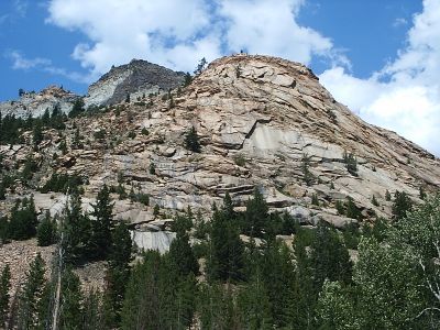
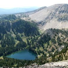
Lost Creek State Park is a natural area featuring grey limestone cliffs and pink granite formations spread across 502 acres. The rock walls create a dramatic canyon system with waterfalls and hiking trails throughout the landscape.

The area was added to the Montana State Parks system in 1957 to protect the natural limestone cliffs and waterfalls. This designation preserved the landscape for public use and recreation over the decades since.

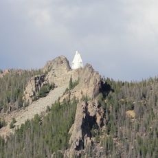
Visitors come here to watch golden eagles, mountain goats, and bighorn sheep moving freely through the canyons and cliffs. The wildlife shapes how people experience and value this place as a wild refuge.

The park charges an entrance fee for non-resident vehicles, while Montana residents with current vehicle registration enter free. Camping sites and trails are available throughout the grounds for different activity levels.

A waterfall within the park drops dramatically and is surrounded by colored granite formations that hikers encounter along the trails. This feature remains less noticed than attractions in neighboring areas.

The community of curious travelers

AroundUs brings together thousands of curated places, local tips, and hidden gems, enriched daily by 60,000 contributors worldwide.

Start exploring
Location
Inception
1957
GPS coordinates
46.20390,-112.99500
Latest update
December 14, 2025 18:41
Around this place
Our Lady of the Rockies
United States of America

Our Lady of the Rockies

48 km
Montana State Prison
United States of America

Montana State Prison

24.9 km
Anaconda Smelter Stack
United States of America

Anaconda Smelter Stack

12.2 km
Dumas Brothel
United States of America

Dumas Brothel

41.5 km
Columbia Gardens
United States of America

Columbia Gardens

46.5 km
Anaconda-Pintler Wilderness
United States of America

Anaconda-Pintler Wilderness

46.1 km
Washoe Theater
United States of America

Washoe Theater

9 km
Mai Wah Museum
United States of America

Mai Wah Museum

41.9 km
Butte-Anaconda Historic District
United States of America

Butte-Anaconda Historic District

38 km
World Museum of Mining
United States of America

World Museum of Mining

39.6 km
Frontier Montana Museum
United States of America

Frontier Montana Museum

28.9 km
Socialist Hall
United States of America

Socialist Hall

44 km
Ancient Order of Hibernians Hall
United States of America

Ancient Order of Hibernians Hall

9 km
Rialto Theatre
United States of America

Rialto Theatre

29.6 km
Burton K. Wheeler House
United States of America

Burton K. Wheeler House

42.8 km
Anaconda City Hall
United States of America

Anaconda City Hall

9.1 km
Deer Lodge County Courthouse
United States of America

Deer Lodge County Courthouse

9.6 km
Butte, Anaconda and Pacific Railway Historic District
United States of America

Butte, Anaconda and Pacific Railway Historic District

26.5 km
Philipsburg Historic District (Philipsburg, Montana)
United States of America

Philipsburg Historic District (Philipsburg, Montana)

27.2 km
Anaconda Commercial Historic District
United States of America

Anaconda Commercial Historic District

9 km
Jefferson County Courthouse
United States of America

Jefferson County Courthouse

67.4 km
Deer Lodge American Women's League Chapter House
United States of America

Deer Lodge American Women's League Chapter House

29.9 km
M.E. Doe House
United States of America

M.E. Doe House

26.8 km
Ringing Rocks
United States of America

Ringing Rocks

65.2 km
Gird Point Lookout
United States of America

Gird Point Lookout

70.6 km
Conley Street Bridge
United States of America

Conley Street Bridge

28.7 km
Granite State Park
United States of America

Granite State Park

23 km
Garrison Bridge
United States of America

Garrison Bridge

38 km
Show the full map
« Lost Creek State Park - Montana state park in Deer Lodge County, United States » is provided by Around Us (aroundus.com). Images and texts are derived from Wikimedia project under a Creative Commons license. You are allowed to copy, distribute, and modify copies of this page, under the conditions set by the license, as long as this note is clearly visible.

Discover hidden gems everywhere you go!

From secret cafés to breathtaking viewpoints, skip the crowded tourist spots and find places that match your style. Our app makes it easy with voice search, smart filtering, route optimization, and insider tips from travelers worldwide. Download now for the complete mobile experience.

Around Us App Screenshot

A unique approach to discovering new places

Le Figaro

All the places worth exploring

France Info

A tailor-made excursion in just a few clicks

20 Minutes

Around Us
Travel Guide & Maps
Download

Send to your phone

QR Code
1

Open the camera app on your mobile.

2

Point at the QR code with your camera. A notification will appear.

3

Tap the notification to open the link.