Chest opened
+${chestReward.xp} XP
Explorer
NOUVEAU ×${chestReward.collectible.quantity}
tapez pour fermer
Chest locked

Open chests in the app

Around Us is built for your phone — chests unlock when you walk, explore and capture nearby places.

Enable Location

We need your location to show you interesting places around you

Discover nearby places

Find interesting locations and hidden gems around you

Precise directions

Get accurate directions and distances to places

Your location is never shared with other users. It's only used when you tap the location button.

Log in to your account

Start exploring — it's free

Trusted by 72,881 travelers worldwide

Continue with Google
Continue with Apple
or

We will send you a code to connect

By continuing, you accept our Terms and Conditions and our Privacy Policy

Check your inbox

We've sent a pincode in your inbox. Please enter the code below.

Jewel Basin
Discussion Reviews Photo
1.9k Popularity

Jewel Basin, Protected area in Montana, United States.

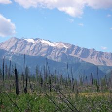
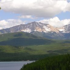
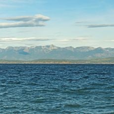
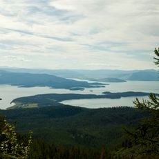
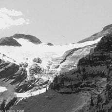
Jewel Basin is a protected area within Flathead National Forest, home to 27 alpine lakes and roughly 35 miles of maintained hiking trails spread throughout the northern Swan Mountain Range. The landscape features open high-elevation terrain with mountain lakes and multiple trailheads connecting to various destinations.

The area gained protection to preserve its natural lakes and mountain forests while maintaining public access for recreation. This designation brought restrictions on motorized vehicles and the creation of the maintained trail network.

Local anglers have long cherished this place for fishing opportunities, particularly for the native westslope cutthroat trout found throughout the alpine lakes. You will notice fishermen spending time by the water, maintaining a tradition that remains central to how people connect with the landscape.

To reach the area, drive up Forest Service Road 5392 to the Camp Misery parking lot where most hikes begin. The warmest and most pleasant months for visiting are late spring through early autumn, when trails are snow-free.

The lakes here are part of a careful rotation program where only certain lakes receive new fish each year rather than all lakes being stocked annually. This thoughtful approach maintains healthy trout populations while allowing some lakes to develop naturally without human intervention.

The community of curious travelers

AroundUs brings together thousands of curated places, local tips, and hidden gems, enriched daily by 60,000 contributors worldwide.

Start exploring
Location
GPS coordinates
48.17030,-113.92400
Latest update
December 14, 2025 11:02
Around this place
Hungry Horse Dam
United States of America

Hungry Horse Dam

20.2 km
Great Bear Wilderness
United States of America

Great Bear Wilderness

25.3 km
Izaak Walton Inn
United States of America

Izaak Walton Inn

26.1 km
United States of America

Bad Rock Canyon

27.6 km
Charles E. Conrad Mansion
United States of America

Charles E. Conrad Mansion

28.2 km
South Fork Flathead River
United States of America

South Fork Flathead River

37.7 km
Wayfarers State Park
United States of America

Wayfarers State Park

17.1 km
West Shore State Park
United States of America

West Shore State Park

29 km
Stanton Glacier
United States of America

Stanton Glacier

21.6 km
International Larix Arboretum
United States of America

International Larix Arboretum

25.8 km
Walton Ranger Station Historic District
United States of America

Walton Ranger Station Historic District

26.5 km
Scandinavian Methodist Church
United States of America

Scandinavian Methodist Church

29.5 km
Kalispell Main Street Historic District
United States of America

Kalispell Main Street Historic District

28.9 km
Courthouse Historic District
United States of America

Courthouse Historic District

28.8 km
Woll House
United States of America

Woll House

29.1 km
A. J. Dean House
United States of America

A. J. Dean House

28.3 km
Snyder House
United States of America

Snyder House

29.7 km
Grant Glacier
United States of America

Grant Glacier

21.3 km
Conrad Mansion
United States of America

Conrad Mansion

28.3 km
Amazing Fun Center
United States of America

Amazing Fun Center

29.7 km
Boyd's Shop
United States of America

Boyd's Shop

29.3 km
Fisher House
United States of America

Fisher House

29.4 km
Beaman House
United States of America

Beaman House

29.4 km
Bruyer Granary
United States of America

Bruyer Granary

29.1 km
Bader-Jaquette and Westwang Houses and Rental Property
United States of America

Bader-Jaquette and Westwang Houses and Rental Property

29.6 km
Glacier Distilling Company - The Whiskey Barn
United States of America

Glacier Distilling Company - The Whiskey Barn

29.5 km
Billsborough House
United States of America

Billsborough House

28.6 km
Woodland Water Park
United States of America

Woodland Water Park

28.2 km
Show the full map
Reviews
Share your experience

No review yet

Discussions
Start a discussion...

No discussion yet

« Jewel Basin - Protected area in Montana, United States » is provided by Around Us (aroundus.com). Images and texts are derived from Wikimedia project under a Creative Commons license. You are allowed to copy, distribute, and modify copies of this page, under the conditions set by the license, as long as this note is clearly visible.

Discover hidden gems everywhere you go!

From secret cafés to breathtaking viewpoints, skip the crowded tourist spots and find places that match your style. Our app makes it easy with voice search, smart filtering, route optimization, and insider tips from travelers worldwide. Download now for the complete mobile experience.

Around Us App Screenshot

A unique approach to discovering new places

Le Figaro

All the places worth exploring

France Info

A tailor-made excursion in just a few clicks

20 Minutes

Around Us
Travel Guide & Maps
Download

Send to your phone

QR Code
1

Open the camera app on your mobile.

2

Point at the QR code with your camera. A notification will appear.

3

Tap the notification to open the link.