Enable Location

We need your location to show you interesting places around you

Discover nearby places

Find interesting locations and hidden gems around you

Precise directions

Get accurate directions and distances to places

Your location is never shared with other users. It's only used when you tap the location button.

Fergus County High School

Log in to your account

Start exploring — it's free

Trusted by 63,413 travelers worldwide

Continue with Google
Continue with Apple
or

We will send you a code to connect

By continuing, you accept our Terms and Conditions and our Privacy Policy

Check your inbox

We've sent a pincode in your inbox. Please enter the code below.

Fergus County High School
Discussion Reviews 1 Photos
1.6k Popularity

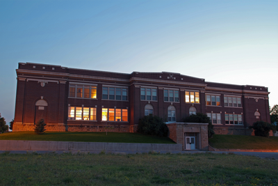
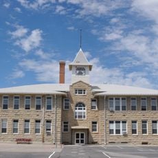
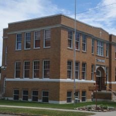
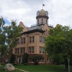
Fergus County High School, Public high school in Lewistown, Montana.

Fergus County High School is a public high school in Lewistown featuring Renaissance Revival and Beaux Arts architectural styles located on 6th Avenue South. The building was designed by J.G. Link and contains multiple educational wings arranged to serve the school's various functions.

The school was established in 1919 and reflects the growth of Lewistown during the early 20th century. In 1985 it was added to the National Register of Historic Places, recognizing its architectural and social significance to the region.

The school functions as a gathering place where students and families from the area come together for sports events and performances that shape community life. These occasions bring residents together and create connections between school activities and public life in town.

The campus includes classrooms, a library, and sports facilities available to students throughout the school day. Visitors should note that the grounds may have limited access during regular school hours.

The building has undergone multiple renovations since its completion, with new wings added to meet modern educational requirements. These expansions show how the school adapted as the region developed and its student population grew.

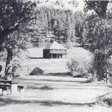
The community of curious travelers

AroundUs brings together thousands of curated places, local tips, and hidden gems, enriched daily by 60,000 contributors worldwide.

Start exploring
Location
GPS coordinates
47.06028,-109.42583
Latest update
December 14, 2025 14:23
Around this place
Sluice Boxes State Park
United States of America

Sluice Boxes State Park

116.1 km
Eye of the Needle
United States of America

Eye of the Needle

106.1 km
Fred Robinson Bridge
United States of America

Fred Robinson Bridge

84.6 km
Big Baldy Mountain
United States of America

Big Baldy Mountain

90.2 km
War Horse National Wildlife Refuge
United States of America

War Horse National Wildlife Refuge

72.3 km
Hailstone National Wildlife Refuge
United States of America

Hailstone National Wildlife Refuge

118.8 km
Loco Mountain
United States of America

Loco Mountain

116.1 km
Milwaukee Road Historic District
United States of America

Milwaukee Road Historic District

76.5 km
Fort Benton Bridge
United States of America

Fort Benton Bridge

125.5 km
Judith Landing Historic District
United States of America

Judith Landing Historic District

76.9 km
Judith River Ranger Station
United States of America

Judith River Ranger Station

69.8 km
Masonic Temple
United States of America

Masonic Temple

496 m
Roundup Central School
United States of America

Roundup Central School

95.8 km
Lavina State Bank
United States of America

Lavina State Bank

93.1 km
St. Benedict's Catholic School
United States of America

St. Benedict's Catholic School

96 km
Lewistown Central Business Historic District
United States of America

Lewistown Central Business Historic District

546 m
Cat Creek Oil Field Sign
United States of America

Cat Creek Oil Field Sign

107.6 km
Masonic Building
United States of America

Masonic Building

125.5 km
Abraham and Mary Walton Hogeland House
United States of America

Abraham and Mary Walton Hogeland House

752 m
Ervin Homestead-Gist Bottom Historic District
United States of America

Ervin Homestead-Gist Bottom Historic District

88.6 km
Lewistown Courthouse Historic District
United States of America

Lewistown Courthouse Historic District

390 m
Fort Benton Engine House
United States of America

Fort Benton Engine House

125.5 km
Anderson House
United States of America

Anderson House

469 m
Lewistown Silk Stocking District
United States of America

Lewistown Silk Stocking District

652 m
Melville Lutheran Church
United States of America

Melville Lutheran Church

115.8 km
Huntoon Residence
United States of America

Huntoon Residence

416 m
Charles M Bair Family Museum
United States of America

Charles M Bair Family Museum

94.9 km
Square Butte
United States of America

Square Butte

77.1 km
Show the full map
Reviews
Share your experience

No review yet

Discussions
Start a discussion...

No discussion yet

« Fergus County High School - Public high school in Lewistown, Montana » is provided by Around Us (aroundus.com). Images and texts are derived from Wikimedia project under a Creative Commons license. You are allowed to copy, distribute, and modify copies of this page, under the conditions set by the license, as long as this note is clearly visible.

Discover hidden gems everywhere you go!

From secret cafés to breathtaking viewpoints, skip the crowded tourist spots and find places that match your style. Our app makes it easy with voice search, smart filtering, route optimization, and insider tips from travelers worldwide. Download now for the complete mobile experience.

Around Us App Screenshot

A unique approach to discovering new places

Le Figaro

All the places worth exploring

France Info

A tailor-made excursion in just a few clicks

20 Minutes

Around Us
Travel Guide & Maps
Download

Send to your phone

QR Code
1

Open the camera app on your mobile.

2

Point at the QR code with your camera. A notification will appear.

3

Tap the notification to open the link.