Chest opened
+${chestReward.xp} XP
Explorer
NOUVEAU ×${chestReward.collectible.quantity}
tapez pour fermer
Chest locked

Open chests in the app

Around Us is built for your phone — chests unlock when you walk, explore and capture nearby places.

Enable Location

We need your location to show you interesting places around you

Discover nearby places

Find interesting locations and hidden gems around you

Precise directions

Get accurate directions and distances to places

Your location is never shared with other users. It's only used when you tap the location button.

Milk River

Log in to your account

Start exploring — it's free

Trusted by 72,879 travelers worldwide

Continue with Google
Continue with Apple
or

We will send you a code to connect

By continuing, you accept our Terms and Conditions and our Privacy Policy

Check your inbox

We've sent a pincode in your inbox. Please enter the code below.

Milk River
Discussion Reviews 1 Photos
18.8k Popularity

Milk River, River system in Alberta and Montana.

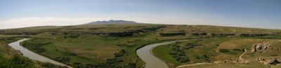
The Milk River is a waterway that winds through Montana and Alberta over approximately 729 miles. It flows through semi-arid land and changes direction by crossing the international border twice.

Early explorers Lewis and Clark documented this river during their expedition and noted its cloudy appearance. The waterway later became an important water source for irrigation across the Montana region.

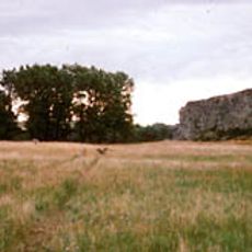
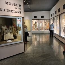
Writing-on-Stone Provincial Park features rock carvings and paintings created by indigenous peoples that mark the valley. These images tell stories of people who have lived in this region for many generations.

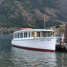
The river is accessible for boating and fishing, with conditions varying by season. The best time to visit is from spring through fall, when water levels are stable.

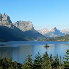
The river has a distinctive milky color from fine clay particles suspended in the water. This natural coloring is immediately visible and gives the waterway its distinctive name.

The community of curious travelers

AroundUs brings together thousands of curated places, local tips, and hidden gems, enriched daily by 60,000 contributors worldwide.

Start exploring
Location
Location
GPS coordinates
48.85554,-113.01954
Latest update
December 7, 2025 10:08
Around this place
Triple Divide Peak
United States of America

Triple Divide Peak

48.2 km
Many Glacier Hotel
United States of America

Many Glacier Hotel

47.2 km
Cardston Alberta Temple
Canada

Cardston Alberta Temple

43.6 km
United States of America

Lewis Overthrust

44 km
Camp Disappointment
United States of America

Camp Disappointment

26.3 km
Canada

Remington Carriage Museum

43 km
Saint Mary Visitor Center, Entrance Station and Checking Stations
United States of America

Saint Mary Visitor Center, Entrance Station and Checking Stations

33.3 km
Cut Bank Ranger Station Historic District
United States of America

Cut Bank Ranger Station Historic District

38.2 km
Sun Camp Fireguard Cabin
United States of America

Sun Camp Fireguard Cabin

46.2 km
Glacier National Park Tourist Trails
United States of America

Glacier National Park Tourist Trails

43.7 km
Saint Mary Ranger Station
United States of America

Saint Mary Ranger Station

33.3 km
Lee Creek Snowshoe Cabin
United States of America

Lee Creek Snowshoe Cabin

46.5 km
Many Glacier Barn and Bunkhouse
United States of America

Many Glacier Barn and Bunkhouse

46.1 km
Roes Creek Campground Camptender's Cabin
United States of America

Roes Creek Campground Camptender's Cabin

40.9 km
Sherburne Ranger Station Historic District
United States of America

Sherburne Ranger Station Historic District

41.2 km
Two Medicine Campground Camptender's Cabin
United States of America

Two Medicine Campground Camptender's Cabin

48.2 km
Slide Lake-Otatso Creek Patrol Cabin and Woodshed
United States of America

Slide Lake-Otatso Creek Patrol Cabin and Woodshed

42.9 km
St. Mary Utility Area Historic District
United States of America

St. Mary Utility Area Historic District

32.7 km
East Glacier Ranger Station Historic District
United States of America

East Glacier Ranger Station Historic District

47.9 km
Singleshot Mountain
United States of America

Singleshot Mountain

37.3 km
Little Chief
United States of America

Little Chief

41.4 km
Saint Mary Lake
United States of America

Saint Mary Lake

41.6 km
Rising Sun Auto Camp Historic District
United States of America

Rising Sun Auto Camp Historic District

40.7 km
Museum of the Plains Indian
United States of America

Museum of the Plains Indian

33.3 km
Two Medicine Campground Amphitheater
United States of America

Two Medicine Campground Amphitheater

47.8 km
Rising Sun Campground
United States of America

Rising Sun Campground

40.9 km
Rising Sun Campground Amphitheater
United States of America

Rising Sun Campground Amphitheater

41 km
Chief Mountain
United States of America

Chief Mountain

44 km
Show the full map
Reviews
Share your experience

No review yet

Discussions
Start a discussion...

No discussion yet

« Milk River - River system in Alberta and Montana » is provided by Around Us (aroundus.com). Images and texts are derived from Wikimedia project under a Creative Commons license. You are allowed to copy, distribute, and modify copies of this page, under the conditions set by the license, as long as this note is clearly visible.

Discover hidden gems everywhere you go!

From secret cafés to breathtaking viewpoints, skip the crowded tourist spots and find places that match your style. Our app makes it easy with voice search, smart filtering, route optimization, and insider tips from travelers worldwide. Download now for the complete mobile experience.

Around Us App Screenshot

A unique approach to discovering new places

Le Figaro

All the places worth exploring

France Info

A tailor-made excursion in just a few clicks

20 Minutes

Around Us
Travel Guide & Maps
Download

Send to your phone

QR Code
1

Open the camera app on your mobile.

2

Point at the QR code with your camera. A notification will appear.

3

Tap the notification to open the link.