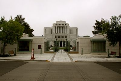
Cardston Alberta Temple, Mormon temple in Cardston, Canada
The Cardston Alberta Temple is a white granite worship building with a compact, pyramid-shaped form that combines geometric elements into a centered layout. The structure contains multiple rooms designed for religious ceremonies and gatherings.
This building was completed in 1923 and was the first temple of The Church of Jesus Christ built outside the United States and the first in the British Empire. Its construction marked an important milestone in the church's expansion beyond American borders.
This worship site holds deep meaning for members of The Church of Jesus Christ of Latter-day Saints, who gather here for religious observances and ceremonies. The interior spaces reflect careful craftsmanship that visitors can appreciate as they move through the building.
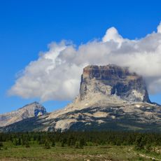
The temple sits in a small town near the United States border and is accessible by local roads. Visitors should know that certain areas operate during set times and that staff members are available to provide information.
Unlike other temples of its era, this building was deliberately designed without a tall spire or a separate assembly hall, reflecting a shift in architectural thinking. This choice shows how the church's building style evolved over time.
Location: Town of Cardston
Operator: The Church of Jesus Christ of Latter-day Saints
GPS coordinates: 49.19821,-113.30928
Latest update: December 7, 2025 20:43
Waterton Lakes National Park
48.4 km
Prince of Wales Hotel
46 km
Many Glacier Hotel
51.4 km
Waterton-Glacier International Peace Park
48.9 kmLewis Overthrust
36.8 km
Mount Cleveland
49.7 km
First Oil Well in Western Canada
51.4 kmRemington Carriage Museum
597 m
Saint Mary Visitor Center, Entrance Station and Checking Stations
51.7 km
Crypt Falls
44.4 km
Old Sun Glacier
49.8 km
Saint Mary Ranger Station
52.1 km
Swiftcurrent Auto Camp Historic District
52 km
Belly River Ranger Station Historic District
41.8 km
Many Glacier Campground Camptender's Cabin
52.2 km
Lee Creek Snowshoe Cabin
32.9 km
Many Glacier Barn and Bunkhouse
50.4 km
Goathaunt Bunkhouse
50.5 km
Sherburne Ranger Station Historic District
46.3 km
Slide Lake-Otatso Creek Patrol Cabin and Woodshed
38.4 km
St. Mary Utility Area Historic District
51.8 km
Swiftcurrent Ranger Station Historic District
52 km
St. Mary Utility Area Gas and Oil House
52 km
Many Glacier Campground
52.2 km
Waterton Reservoir
29.6 km
Chief Mountain
36.8 km
Registration Building
40 km
Lake Sherburne
47 kmVisited this place? Tap the stars to rate it and share your experience / photos with the community! Try now! You can cancel it anytime.
Discover hidden gems everywhere you go!
From secret cafés to breathtaking viewpoints, skip the crowded tourist spots and find places that match your style. Our app makes it easy with voice search, smart filtering, route optimization, and insider tips from travelers worldwide. Download now for the complete mobile experience.
A unique approach to discovering new places❞
— Le Figaro
All the places worth exploring❞
— France Info
A tailor-made excursion in just a few clicks❞
— 20 Minutes