Trapper’s Shack, house in Fort Vermilion, Mackenzie County, Alberta
Location: Mackenzie County
Address: 5003 River Road
GPS coordinates: 58.23420,-116.01043
Latest update: January 19, 2024 22:05
Wood Buffalo National Park
216.4 km
Saltos Vermilion
68.4 km
Caribou Mountains Wildland Provincial Park
134.7 km
Peace River Formation
240.1 km
Birch Mountains Wildland Provincial Park
197.9 km
Notikewin Provincial Park
131.3 km
Hay-Zama Lakes Wildland Provincial Park
184.8 km
60th Parallel Territorial Park
204.3 km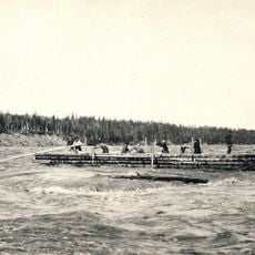
Vermilion Chutes
68.3 km
Bad Rapids
151 km
Boyer Rapids
219.3 km
Battle River Hospital
175.1 km
Eaglenest Portage Site
234.3 km
Warden's Patrol Cabin
205.7 km
Plavin Homestead
182.4 km
Grumbler Rapids
223.3 km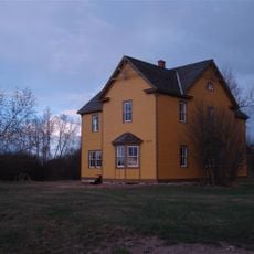
Fort Vermilion
18 km
Hudson's Bay Company Factor's House
18 km
Fox Haven Golf & Country Club
72.9 km
NWT Sign
204.2 km
Centennial Spray Park
72.9 km
Rainbow Lake Golf & Country Club
200.5 km
Tower, Observation tower, scenic viewpoint
212 km
Vermilion Rapids
65.5 km
Mozzy the Mosquito
200.2 km
Scenic viewpoint
169.2 km
Tower, Observation tower, scenic viewpoint
110.9 km
Athabasca Hall
235.6 kmReviews
Visited this place? Tap the stars to rate it and share your experience / photos with the community! Try now! You can cancel it anytime.
Discover hidden gems everywhere you go!
From secret cafés to breathtaking viewpoints, skip the crowded tourist spots and find places that match your style. Our app makes it easy with voice search, smart filtering, route optimization, and insider tips from travelers worldwide. Download now for the complete mobile experience.

A unique approach to discovering new places❞
— Le Figaro
All the places worth exploring❞
— France Info
A tailor-made excursion in just a few clicks❞
— 20 Minutes