Enable Location

We need your location to show you interesting places around you

Discover nearby places

Find interesting locations and hidden gems around you

Precise directions

Get accurate directions and distances to places

Your location is never shared with other users. It's only used when you tap the location button.

Pano Lefkara

Log in to your account

Start exploring — it's free

Trusted by 61,441 travelers worldwide

Continue with Google
Continue with Apple
or

We will send you a code to connect

By continuing, you accept our Terms and Conditions and our Privacy Policy

Check your inbox

We've sent a pincode in your inbox. Please enter the code below.

Pano Lefkara

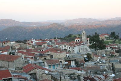
Pano Lefkara, Mountain village with lace crafts in Larnaca District, Cyprus.

Description

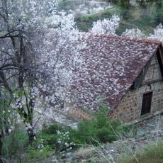
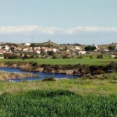
Pano Lefkara is a mountain village with stone houses lining narrow streets at approximately 575 meters elevation, surrounded by limestone hills in southeastern Cyprus. The settlement contains multiple craft workshops, restaurants, and a Folk Art Museum housed in the Patsalos building.

History

The settlement originated during the Byzantine period and reached its peak in the 16th century when it became the largest town in Cyprus. This era established the place as a major center on the island.

Culture

Local women create intricate lace patterns using techniques inherited through generations, while silversmiths produce detailed filigree work that remains central to village life. These crafts are visible in workshops throughout the settlement and shape how residents and visitors experience the place.

Practical

The village sits about 30 kilometers from Larnaca airport and is reached by paved roads through surrounding hills. It is best visited early in the day when fewer visitors are present and the streets feel less crowded.

Did you know?

Leonardo da Vinci acquired a lace cloth from the village around 1481, intended as a gift for Milan Cathedral. This event shows how far the reputation of its craftspeople had spread by that time.

Location
Elevation above the sea
575 m
Part of
Larnaca District
Shares border with
Vavatsinia, Lazanias, Lythrodontas, Delikipos, Kornos, Kofinou, Kato Lefkara, Skarinou, Kato Drys, Vavla, Lageia, Choirokoitia
GPS coordinates
34.81667,33.28333
Latest update
December 6, 2025 17:40

AroundUs brings together thousands of curated places, local tips, and hidden gems, enriched daily by 60,000 contributors worldwide. Discover all places nearby (Larnaca District).

Photography locations in Cyprus

Cyprus offers a range of locations for photography that blend history, nature, and architecture. The island presents ancient ruins such as the archaeological parks of Paphos and the sanctuary of Kourion, medieval castles including Saint Hilarion and Kolossi, and churches dating to the Byzantine...

« Pano Lefkara - Mountain village with lace crafts in Larnaca District, Cyprus » is provided by Around Us (aroundus.com). Images and texts are derived from Wikimedia project under a Creative Commons license. You are allowed to copy, distribute, and modify copies of this page, under the conditions set by the license, as long as this note is clearly visible.

Discover hidden gems everywhere you go!

From secret cafés to breathtaking viewpoints, skip the crowded tourist spots and find places that match your style. Our app makes it easy with voice search, smart filtering, route optimization, and insider tips from travelers worldwide. Download now for the complete mobile experience.

Around Us App Screenshot

A unique approach to discovering new places

Le Figaro

All the places worth exploring

France Info

A tailor-made excursion in just a few clicks

20 Minutes

Around Us
Travel Guide & Maps
Download

Send to your phone

QR Code
1

Open the camera app on your mobile.

2

Point at the QR code with your camera. A notification will appear.

3

Tap the notification to open the link.