Enable Location

We need your location to show you interesting places around you

Discover nearby places

Find interesting locations and hidden gems around you

Precise directions

Get accurate directions and distances to places

Your location is never shared with other users. It's only used when you tap the location button.

Peace Bridge

Log in to your account

Start exploring — it's free

Trusted by 63,087 travelers worldwide

Continue with Google
Continue with Apple
or

We will send you a code to connect

By continuing, you accept our Terms and Conditions and our Privacy Policy

Check your inbox

We've sent a pincode in your inbox. Please enter the code below.

Discussion Reviews 1 Photos
42.3k Popularity

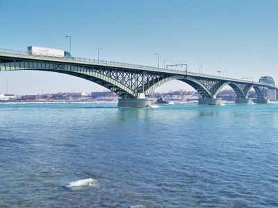
Peace Bridge, International deck arch bridge in Buffalo, United States.

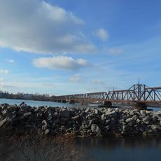
The Peace Bridge is an international steel arch structure that carries highway traffic across the Niagara River between Buffalo in New York State and Fort Erie in Ontario. The design consists of five consecutive arch segments that span roughly 1,770 meters in total length, linking both shores and a low mid-river island along the way.

The crossing opened in August 1927 after two years of construction, creating the first road link between Lake Erie and Niagara Falls. Its name honors the peaceful relations between Canada and the United States after more than a century of shared border without military conflict.

Four thousand trucks cross this border point daily, making it a central connection for commerce between Canada and the United States.

The structure carries three traffic lanes with a center lane that reverses direction during rush hours, plus two walkways on the sides for people on foot or bicycles. Pedestrians and cyclists should expect stronger winds, as the span sits exposed above the river with no windbreak.

Engineers assembled the arch segments in free air above the water without building scaffolding from the riverbed, an unusual method for that era. Each of the large arch sections was floated into position on pontoons and then connected from both shores simultaneously.

The community of curious travelers

AroundUs brings together thousands of curated places, local tips, and hidden gems, enriched daily by 60,000 contributors worldwide.

Start exploring
Location
Location
Inception
June 1, 1927
Official opening
August 7, 1927
Longest Span
130 m
Part of
Canada–United States border
GPS coordinates
42.90690,-78.90560
Latest update
December 17, 2025 07:48
Around this place
Kleinhans Music Hall
United States of America

Kleinhans Music Hall

1.9 km
Fort Erie
Canada

Fort Erie

2.1 km
International Railway Bridge
Canada

International Railway Bridge

2.5 km
Delaware Avenue Historic District
United States of America

Delaware Avenue Historic District

2.7 km
Broderick Park
United States of America

Broderick Park

914 m
First Presbyterian Church
United States of America

First Presbyterian Church

2 km
West Village Historic District
United States of America

West Village Historic District

2.6 km
Fort Porter
United States of America

Fort Porter

1 km
Clement House
United States of America

Clement House

2.7 km
Williams-Butler Mansion
United States of America

Williams-Butler Mansion

2.7 km
Buffalo Tennis and Squash Club
United States of America

Buffalo Tennis and Squash Club

2.3 km
Statue of Christopher Columbus
United States of America

Statue of Christopher Columbus

1.2 km
Fargo Estate Historic District
United States of America

Fargo Estate Historic District

1.4 km
Elmwood Historic District–West
United States of America

Elmwood Historic District–West

2.6 km
Williams-Pratt House
United States of America

Williams-Pratt House

2.7 km
Engine House No. 2 and Hook and Ladder No. 9
United States of America

Engine House No. 2 and Hook and Ladder No. 9

1.6 km
Buffalo Public School No. 77
United States of America

Buffalo Public School No. 77

1.1 km
Annunciation School
United States of America

Annunciation School

2 km
Ferry Street Bridge
United States of America

Ferry Street Bridge

965 m
Buffalo Milk Company Building
United States of America

Buffalo Milk Company Building

641 m
Richmond Avenue Methodist-Episcopal Church
United States of America

Richmond Avenue Methodist-Episcopal Church

2.2 km
Allentown Historic District
United States of America

Allentown Historic District

2.3 km
The Wayne and The Waldorf Apartments
United States of America

The Wayne and The Waldorf Apartments

2.5 km
Westminster Presbyterian Church
United States of America

Westminster Presbyterian Church

2.7 km
The Karnak Flats
United States of America

The Karnak Flats

2.5 km
The Virginia
United States of America

The Virginia

2.3 km
Lafayette High School
United States of America

Lafayette High School

2.3 km
North Hall - The Karpeles Manuscript Library Museum
United States of America

North Hall - The Karpeles Manuscript Library Museum

2.4 km
Show the full map
Reviews
Share your experience

No review yet

Discussions
Start a discussion...

No discussion yet

« Peace Bridge - International deck arch bridge in Buffalo, United States » is provided by Around Us (aroundus.com). Images and texts are derived from Wikimedia project under a Creative Commons license. You are allowed to copy, distribute, and modify copies of this page, under the conditions set by the license, as long as this note is clearly visible.

Discover hidden gems everywhere you go!

From secret cafés to breathtaking viewpoints, skip the crowded tourist spots and find places that match your style. Our app makes it easy with voice search, smart filtering, route optimization, and insider tips from travelers worldwide. Download now for the complete mobile experience.

Around Us App Screenshot

A unique approach to discovering new places

Le Figaro

All the places worth exploring

France Info

A tailor-made excursion in just a few clicks

20 Minutes

Around Us
Travel Guide & Maps
Download

Send to your phone

QR Code
1

Open the camera app on your mobile.

2

Point at the QR code with your camera. A notification will appear.

3

Tap the notification to open the link.