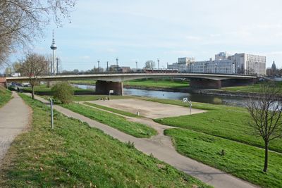
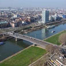
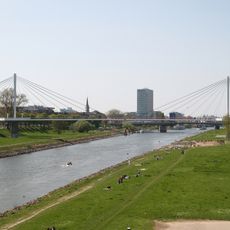
Friedrich-Ebert-Brücke, Road bridge over Neckar River in Mannheim, Germany.
The Friedrich-Ebert-Brücke is a road bridge crossing the Neckar River in Mannheim with three parallel structures accommodating cars, trams, bicycles, and pedestrians. The structure links the northeast part of the city to its center and organizes traffic flow with dedicated lanes for each mode of transport.
The original structure was built in 1926 and destroyed in 1945 during World War II. It was reconstructed in 1946 with its original name restored.
The bridge carries the name of Friedrich Ebert, Germany's first Weimar Republic president, marking the country's shift toward democracy after World War I. This naming reflects how public infrastructure honors key figures in the nation's political transformation.
The bridge serves as part of Federal Highway B38 and accommodates multiple types of traffic users. Access is straightforward, and the multiple parallel structures make navigation safe for pedestrians and cyclists.
In 2006, an entire section of the bridge was replaced while traffic continued flowing on parallel structures. This engineering approach allowed modernization without cutting off the city's connection.
Location: Mannheim
Inception: May 1, 1946
GPS coordinates: 49.49140,8.48175
Latest update: December 14, 2025 11:03
National Theatre Mannheim
467 m
Watertower of Mannheim
940 m
Fernmeldeturm Mannheim
905 m
Mannheim University Hospital
462 m
Lanz-Villa
879 m
Collini-Center
293 m
Neckaruferbebauung-Nord
572 m
Mannheimer Rosengarten
815 m
Christuskirche Mannheim
761 m
Herschel bath
719 m
Friedrichsplatz
932 m
Alte Feuerwache
718 m
Hauptfriedhof Mannheim
741 m
Capitol
939 m
Kurpfalzbrücke
762 m
Jüdischer Friedhof Mannheim
858 m
Neckarsteg
358 m
Bahnhof Mannheim-Neckarstadt
791 m
Melanchthonkirche
738 m
Neuapostolische Kirche
734 m
National Theatre Mannheim
467 m
Werkhaus
286 m
Library for the Medical Faculty of Mannheim of the University of Heidelberg
376 m
Unterer Neckar: Mannheimer Neckaraue
431 m
1 Maulbeere, Wohlgelegen, Feudenheimer Straße (vor Friedhofsamt)
827 m
1 Maulbeerbaum, Wohlgelegen, Feudenheimer Straße (Parkplatz v. MA-RU-BA)
795 m
Platane, Oststadt, Ecke Sophien-/Mollstr.
911 m
ÖVA-Passage
917 mVisited this place? Tap the stars to rate it and share your experience / photos with the community! Try now! You can cancel it anytime.
Discover hidden gems everywhere you go!
From secret cafés to breathtaking viewpoints, skip the crowded tourist spots and find places that match your style. Our app makes it easy with voice search, smart filtering, route optimization, and insider tips from travelers worldwide. Download now for the complete mobile experience.
A unique approach to discovering new places❞
— Le Figaro
All the places worth exploring❞
— France Info
A tailor-made excursion in just a few clicks❞
— 20 Minutes