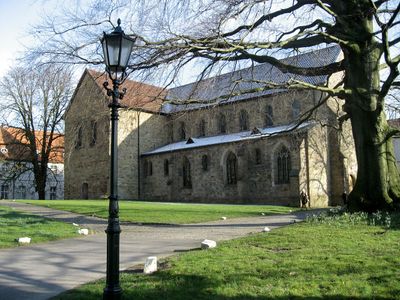
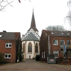
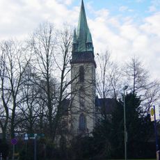
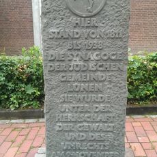
Stiftskirche Cappenberg, Romanesque church in Selm, Germany
Stiftskirche Cappenberg is a three-aisled basilica with a transept in Selm, displaying Romanesque architecture enhanced by Gothic modifications from the 14th and 15th centuries. The building features a substantial choir, slender pillars, and windows that were modified and renewed over the centuries.
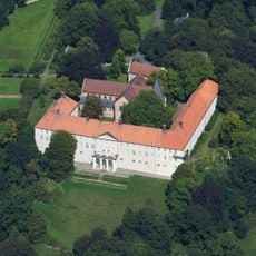
The building was founded in the 12th century by Otto and Gottfried von Cappenberg and served as the first Premonstratensian monastery in Westphalia until 1802. This religious institution shaped the spiritual landscape of the region for centuries.
The church serves as a spiritual center for the local community, actively used for worship and religious gatherings throughout the year. People experience here the continuity of faith that has shaped this corner of Westphalia for centuries.
The site is accessible year-round to visitors interested in exploring medieval architecture and historical objects on display. Guided tours are available for those seeking deeper insights into the building's construction history and holdings.
The building houses the Cappenberger Barbarossakopf, a bronze reliquary bust of Emperor Friedrich Barbarossa crafted in Aachen after 1155. This remarkable artwork stands as one of the region's oldest monuments and demonstrates the exceptional artistic skill of the medieval period.
Location: Selm
GPS coordinates: 51.65090,7.53908
Latest update: December 12, 2025 16:40
Cappenberg Castle
50 m
Christoph 8
4 kmBeckinghausen
4.4 km
St. Marien
4 km
Alte Kaffeerösterei
3.1 km
Heinz-Hilpert-Theater
4.5 km
Evangelische Stadtkirche Lünen
4.4 km
Rathaus
4.3 km
Kantine Westfalia
3.7 km
Ziegelei Siegeroth
2.9 km
Herz-Jesu-Kirche
4.6 km
Villa Urbahn
4.3 km
Jüdischer Friedhof
3.5 km
Synagoge (Lünen)
4.3 km
Lippeaue von Wethmar bis Lünen
3.8 km
Wälder bei Cappenberg-West
2.5 km
Lippeaue von Werne bis Heil
4.6 km
Persiluhr
3.9 km
Stadtarchiv Lünen
4.2 km
Landschaftsschutzgebiet Geist und Hof Schulze Wethmar, nördlich der Lippe, südlich der Münsterstraße, östlich der Eisenhütte Westfalia
3.3 km
LSG-Gelte, noerdlich des Lippedeiches, suedlich der Alstedder Strasse und suedwestlich der Klaeranlage
4.1 km
Landschaftsschutzgebiet Weege, Beckhof, nördlich der Münsterstraße, südlich der Bahnlinie und beiderseits des Kiliansbaches
2.5 km
LSG-Lippeaue, nordoestlich der STEAG, noerdlich der Moltkestrasse
4.6 km
Landschaftsschutzgebiet Nr. 8
2.8 km
Landschaftsschutzgebiet Nr. 3
3.6 km
In den Kämpen, Im Mersche und Langerner Hufeisen
3.2 km
Wälder bei Cappenberg
753 m
Schulzentrum Altlünen
2.4 kmVisited this place? Tap the stars to rate it and share your experience / photos with the community! Try now! You can cancel it anytime.
Discover hidden gems everywhere you go!
From secret cafés to breathtaking viewpoints, skip the crowded tourist spots and find places that match your style. Our app makes it easy with voice search, smart filtering, route optimization, and insider tips from travelers worldwide. Download now for the complete mobile experience.
A unique approach to discovering new places❞
— Le Figaro
All the places worth exploring❞
— France Info
A tailor-made excursion in just a few clicks❞
— 20 Minutes