Chest opened
+${chestReward.xp} XP
Explorer
NOUVEAU ×${chestReward.collectible.quantity}
tapez pour fermer

See the monuments around you in AR Open chests in the app

Around Us is built for your phone — point your camera at the streets and discover the monuments and places around you in augmented reality. Around Us is built for your phone — chests unlock when you walk, explore and capture nearby places.

•

Enable Location

We need your location to show you interesting places around you

Discover nearby places

Find interesting locations and hidden gems around you

Precise directions

Get accurate directions and distances to places

Your location is never shared with other users. It's only used when you tap the location button.

Aakerfährbrücke

Log in to your account

Start exploring — it's free

Trusted by 92,835 travelers worldwide

Continue with Google
Continue with Apple
or

We will send you a code to connect

By continuing, you accept our Terms and Conditions and our Privacy Policy

Check your inbox

We've sent a pincode in your inbox. Please enter the code below.

Aakerfährbrücke

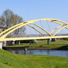
Aakerfährbrücke, Road bridge in Duisburg, Germany

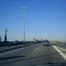
The Aakerfährbrücke is a road bridge that crosses the Ruhr River, connecting the districts of Duissern and Meiderich. It has four traffic lanes plus separate pathways for pedestrians and cyclists on each side.

A ford crossed the Ruhr here in early settlement times, later replaced by a ferry first mentioned in 1359, the Aakerfähre, about 150 metres downstream. The first fixed bridge was built between 1902 and 1904, planned by the Harkort bridge company of Duisburg and decorated by Berlin architect Bruno Möhring. It was badly damaged in autumn 1944 and reopened almost unchanged in 1946; structural damage in the early 1990s led to a complete rebuild.

The name refers to a historic ferry service that once connected the two river banks at this location. Walking across today, visitors can still see the old tram tracks embedded in the roadway, serving as a reminder of how people once moved through the city.

The bridge is crossed by four lanes of road traffic; the wide pedestrian and cycle paths on both sides are separated from the carriageway. The tram tracks still lie in the middle lanes, a reminder that trams shared the road with cars until the Duissern–Meiderich line closed in 2000.

Despite streetcar service ending decades ago, the original tram tracks remain embedded in the road surface and create an interesting visual detail. They serve as a tangible reminder of when the city relied on this network to move people around.

The community of curious travelers

AroundUs brings together thousands of curated places, local tips, and hidden gems, enriched daily by 92,835 contributors worldwide.


Start exploring
Location
Inception
March 16, 1997
GPS coordinates
51.44970,6.79194
Latest update
October 24, 2026 20:13
Reviews
Share your experience

No review yet

Discussions
Start a discussion...

No discussion yet

« Aakerfährbrücke - Road bridge in Duisburg, Germany » is provided by Around Us (aroundus.com). Images and texts are derived from Wikimedia project under a Creative Commons license. You are allowed to copy, distribute, and modify copies of this page, under the conditions set by the license, as long as this note is clearly visible.

Discover hidden gems everywhere you go!

From secret cafés to breathtaking viewpoints, skip the crowded tourist spots and find places that match your style. Our app makes it easy with voice search, smart filtering, route optimization, and insider tips from travelers worldwide. Download now for the complete mobile experience.
Around Us App Screenshot
❝

A unique approach to discovering new places❞

— Le Figaro

❝

All the places worth exploring❞

— France Info

❝

A tailor-made excursion in just a few clicks❞

— 20 Minutes

Around Us
Travel Guide & Maps
Download

Send to your phone

QR Code
1

Open the camera app on your mobile.

2

Point at the QR code with your camera. A notification will appear.

3

Tap the notification to open the link.